Related Research Articles

A cable-stayed bridge has one or more towers, from which cables support the bridge deck. A distinctive feature are the cables or stays, which run directly from the tower to the deck, normally forming a fan-like pattern or a series of parallel lines. This is in contrast to the modern suspension bridge, where the cables supporting the deck are suspended vertically from the main cable, anchored at both ends of the bridge and running between the towers. The cable-stayed bridge is optimal for spans longer than cantilever bridges and shorter than suspension bridges. This is the range within which cantilever bridges would rapidly grow heavier, and suspension bridge cabling would be more costly.

Gilgit is the capital city of Gilgit–Baltistan, a territory comprising the northern region of Pakistani–administered Kashmir. The city is located in a broad valley near the confluence of the Gilgit River and Hunza River. Gilgit is a major tourist destination in Pakistan, and serves as a hub for trekking and mountaineering expeditions in the Karakoram mountain range.

The Karakoram Highway is a 1,300 km (810 mi) national highway which extends from Hasan Abdal in the Punjab province of Pakistan to the Khunjerab Pass in Gilgit-Baltistan, where it crosses into China and becomes China National Highway 314. The highway connects the Pakistani provinces of Punjab and Khyber Pakhtunkhwa plus Gilgit-Baltistan with China's Xinjiang Uyghur Autonomous Region. The highway is a popular tourist attraction and is one of the highest paved roads in the world, passing through the Karakoram mountain range, at 36°51′00″N75°25′40″E at maximum elevation of 4,714 m (15,466 ft) near Khunjerab Pass. Due to its high elevation and the difficult conditions in which it was constructed, it is often referred to as the Eighth Wonder of the World. The highway is also a part of the Asian Highway AH4.

Baglung is a municipality in western Nepal, 275 km (171 mi) west of Kathmandu. It is the administrative headquarters of Baglung District and Dhaulagiri Zone. Baglung serves as the major center for business, finance, education, service and healthcare for the people of mid-Kali Gandaki valley that encompass Beni, Jaljala, Baglung, Kushma, Kathekhola, Galkot, Phalewas and Jaimuni local bodies. The city is located at the cross-section of Kaligandaki corridor highway and midhill highway that transverse Nepal in north–south and east–west directions respectively.
This is a list of trails in Ithaca, New York.

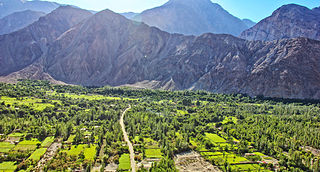
Naltar is a valley near Gilgit,[Gilgit Baltistan] in the Gilgit–Baltistan region of Pakistan. Naltar is about 34 kilometres (21 mi) from Gilgit and can be reached by jeeps. Naltar is a forested region known for its dramatic mountain scenery. Naltar valley is also famous for the three lakes i.e., are Strangi lake, Blue lake and Bodlok lake. There is also a natural lush green garden known as "Halima garden". Tourists can reach Naltar valley using 4×4 vehicles.

Gilgit Valley is a valley located in Gilgit District in Gilgit-Baltistan, northern Pakistan. The Gilgit River flows through the valley. 375 km of road connects it to the town of Chitral via the Shandur Pass.

Tōtara Park is a suburb of Upper Hutt, New Zealand, located 2 km northeast of the city centre. It is accessed via the Tōtara Park Bridge which crosses the Hutt River, connecting it to State Highway 2 and the main Upper Hutt urban area. It was popular in the 1970s and 1980s for families moving into the Upper Hutt area.

Funen, with an area of 3,099.7 square kilometres (1,196.8 sq mi), is the third-largest island of Denmark, after Zealand and Vendsyssel-Thy. It is the 165th-largest island in the world. It is located in the central part of the country and has a population of 469,947 as of 2020. Funen's main city is Odense, which is connected to the sea by a seldom-used canal. The city's shipyard, Odense Steel Shipyard, has been relocated outside Odense proper.
Thul is an administrative subdivision of Jacobabad District in the Sindh province of Pakistan. The subdivision is administratively subdivided into 24 Union Councils, two of which form the capital, Thul. Thul is one of the densely populated Taluka of District Jacobabad, spreading over 317,520 acres. It consists of about half of the population of whole district and its population is approximately 356,705. There are 19 union councils and 96 Dehs in this taluka. The headquarters of this taluka are about 33 km at the east side of district headquarters and connected with rail and road with other parts such as Kandhkot, Shikarpur and Baluchistan province.
Juglot or Jaglot is a city in Gilgit District, Pakistan, and is situated 45 km south east of Gilgit on the Karakoram Highway. It is located at the junction of three mightiest mountain ranges, the Karakorum, Hindukush, and Himalayas.It is also the junction where the ways of Gilgit and Skardu splits in different directions. The road to Skardu branches off about six kilometers towards Gilgit.
Chamogarh is a village 20 km from Gilgit city, in Gilgit-Baltistan. The word Chamogarh is derived from a Chammou mean fish in min local language. Danyor Alam bridge road crosses Chamogarh, it also connects it to Jalalabad, Danyor, Oshkhindass and Alam bridge. In the west, it is connected to the village of Harating, Jalalabad, Gilgit City, Hunza and Khunjerab top to China. Chamogarh has an intervening width of mountains.

Built with a combination of iron rods and wood over the Gilgit River, the Alam Bridge is one of the scariest bridges in the world. The bridge linking Baltistan region to Gilgit and the rest of the country is about 300 metres in length.

Danyor is a city in the namesake sub-division in Gilgit District lies across the river Gilgit in the outskirts of the capital of Gilgit-Baltistan. It is known for its green fields, and poplar trees. The world's highest paved road KKH passes through its landscape.

Tourism in Gilgit-Baltistan, an administrative unit of Pakistan, focuses on the mountains. Gilgit-Baltistan borders Pakistan's Khyber Pakhtunkhwa Province to the west, a small portion of the Wakhan Corridor of Afghanistan to the north, Xinjiang, China to the northeast, the Indian-administered Jammu and Kashmir and Ladakh to the southeast, and the Pakistani-administered state of Azad Kashmir to the south.
Nomal is a small valley located at a distance of 25 km north of Gilgit city in the Gilgit District, in northern Pakistan. The valley is also connected with Nalter Bala and Nalter Pain through a metaled road.

The Danyore Suspension Bridge is in the Gilgit-Baltistan region of Pakistan, and is one of the oldest makeshift suspension bridges in the region. The bridge connects Danyor to the premises of the Karakoram University across the River Hunza. Currently the bridge is closed for vehicles; only pedestrians and motorcyclists are allowed to pass through. Winds coming from northwest of the valley set the suspension brige to swing inducing minute resonances, and it is therefore declared unsafe for normal traffic. In 2013 a two-way concrete bridge was constructed beside it that is being used as an alternative.
Aga Khan Higher Secondary School, Gilgit or AKHSS, Gilgit is a high school, located in Konodas, across river Gilgit, near Gilgit city. It is part of the Agha Khan Schools Network. The school was established in 1998. It is affiliated with Agha Khan Education Board.

Bunji Bridge is a suspension bridge on the Indus River near Bunji, a town in the Astore District of Gilgit-Baltistan, Pakistan. It was first built in the 19th century by the Maharaja Pratap Singh's government of the princely state of Jammu and Kashmir. Its wooden girders were burnt down during the 1947 Gilgit Rebellion and subsequently repaired. It fell into disuse and neglect in recent decades. It was restored by the recently established Government of Gilgit-Baltistan in 2012 after the 2010 Indus floods highlighted its value. The bridge is said to serve as a vital link between the town of Gilgit and the locations in the Astore District.
References
| | This Gilgit-Baltistan location article is a stub. You can help Wikipedia by expanding it. |