
Roxbury is a neighborhood within the City of Boston, Massachusetts, United States.
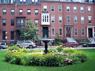
The South End is a neighborhood in Boston, Massachusetts, United States which is bordered by Back Bay, Chinatown, and Roxbury. It is distinguished from other neighborhoods by its Victorian-style houses and the parks in and around the area. The South End is the largest intact Victorian row-house district in the country, covering over 300 acres (120 ha). It has eleven residential parks. In 1973, the South End was listed on the National Register of Historic Places. Much of the neighborhood was originally marshlands in Boston's South Bay. After it was filled in, construction began in 1849.
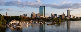
Back Bay is an officially recognized neighborhood of Boston, Massachusetts, built on reclaimed land in the Charles River basin. Construction began in 1859, as the demand for luxury housing exceeded the availability in the city at the time, and the area was fully built by around 1900. It is most famous for its rows of Victorian brownstone homes—considered one of the best preserved examples of 19th-century urban design in the United States—as well as numerous architecturally significant individual buildings, and cultural institutions such as the Boston Public Library, and Boston Architectural College. Initially conceived as a residential-only area, commercial buildings were permitted from around 1890, and Back Bay now features many office buildings, including the John Hancock Tower, Boston's tallest skyscraper. It is also considered a fashionable shopping destination and home to several major hotels.
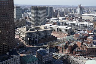
Government Center is an area in downtown Boston, centered on City Hall Plaza. Formerly the site of Scollay Square, it is now the location of Boston City Hall, courthouses, state and federal office buildings, and a major MBTA subway station, also called Government Center. Its development was controversial, as the project displaced thousands of residents and razed several hundred homes and businesses.
Union Square is a neighborhood in the southeastern part of Somerville, Massachusetts, United States. It is centered on Union Square proper, which is located at the intersection of Washington Street, Webster Avenue, and Somerville Avenue.

Roslindale is a primarily residential neighborhood of Boston, Massachusetts, United States, bordered by Jamaica Plain, Hyde Park, West Roxbury and Mattapan. It is served by an MBTA Commuter Rail line, several MBTA bus lines and the MBTA Orange Line in nearby Jamaica Plain. Roslindale has its own branch of the Boston Public Library, the neighborhood is covered by Boston Police District E-5 in West Roxbury, Boston EMS Ambulance 17 is stationed in Roslindale, and the Boston Fire Department has a station on Canterbury Street which houses Ladder 16, Engine 53 & District Chief 12. Roslindale's original Engine Company 45, was deactivated on April 10, 1981, due to budget cuts. Roslindale was once called the "garden suburb" of Boston. The portion of the Arnold Arboretum south of Bussey Street is located in Roslindale.

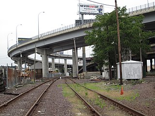
Interstate 695 was a planned six-lane auxiliary Interstate Highway in Boston, Massachusetts, that would have run through parts of Boston, Brookline, Cambridge, and Somerville.

Ashmont is a section of the Dorchester neighborhood of Boston. It includes the subsections of Ashmont Hill, Peabody Square, and Ashmont-Adams. Located near the Milton/Boston border, major streets include Ashmont Street, Gallivan Blvd., and Dorchester Avenue.
East Cambridge is a neighborhood of Cambridge, Massachusetts. East Cambridge is bounded by the Charles River and the Charlestown neighborhood of Boston on the east, the Somerville border on the north, Broadway and Main Street on the south, and the railroad tracks on the west. Most of the streets form a grid aligned with Cambridge Street, which was laid out to directly connect what is now the Charles River Dam Bridge with what in 1809 was the heart of Cambridge, Harvard Square. The northern part of the grid is a roughly six by eight block residential area. Cambridge Street itself is retail commercial, along with Monsignor O'Brien Highway, the Twin Cities Plaza strip mall, and the enclosed Cambridgeside Galleria. Lechmere Square is the transportation hub for the northern side. The southern half of the grid is largely office and laboratory space for hundreds of dot-com companies, research labs and startups associated with MIT, biotechnology firms including Genzyme, Biogen and Moderna, the Athenaeum Press Building, light industry, an NRG Energy power station, and various small businesses. This half of the neighborhood is generally identified with Kendall Square. Along the waterfront are several hotels and taller apartment buildings.

South Medford is the southern neighborhood of Medford, Massachusetts.

Bay Village is the smallest officially recognized neighborhood of Boston, Massachusetts, United States. As of 2010, its population was approximately 1,312 residents living in 837 housing units, most of which are small brick rowhouses.

Mission Hill is a 3⁄4 square mile, primarily residential neighborhood of Boston, bordered by Roxbury, Jamaica Plain and Fenway-Kenmore and the town of Brookline. The neighborhood has two main streets, namely Tremont Street and Huntington Ave. It is served by several stations on the MBTA's Green Line E branch, as well as Roxbury Crossing station on the Orange Line.
Maverick Square is a section of the neighborhood of East Boston in Boston, Massachusetts, United States. It is East Boston's oldest commercial center. At the heart of the square is Maverick Station, which is part of the Blue Line of the MBTA.
Columbus, the state capital and Ohio's largest city, has numerous neighborhoods within its city limits. Neighborhood names and boundaries are not officially defined. They may vary or change from time to time due to demographic and economic variables.
Chester Square is a residential garden square located along Massachusetts Avenue in Boston, between Tremont Street and Shawmut Avenue. The name "Chester" is derived from the original name of the street, which was renamed Massachusetts Avenue on March 1, 1894. Chester Park is also located in the historic South End of Boston.
The Inner Belt District is a 126-acre (0.51 km2) industrial district located in the southeastern portion of Somerville, Massachusetts, United States. Along with nearby Brickbottom, the Inner Belt is a historically industrial zone of Somerville, with factories, warehouses, distribution centers, railroad connections, regional maintenance facilities, MBTA and Amtrak offices, retail stores and a hotel.

Pill Hill is a neighborhood in the Calumet Heights community area on the South Side of Chicago, Illinois, United States.
The West Side is a large area defining many neighborhoods in the city of Manchester, New Hampshire, in the United States. It consists of all parts of the city that lie west of the Merrimack River and includes the neighborhoods of Northwest Manchester, Rimmon Heights, Notre Dame, Piscataquog, Wolfe Park, and Mast Road. It lies just to the east of the community of Pinardville in the neighboring town of Goffstown.
The North End is a neighborhood located in Detroit, Michigan. It is located in the Woodward Corridor, a densely populated region along Woodward Avenue that stretches from Downtown Detroit to the suburb of Pontiac. The North End has been home to several development initiatives, seen by many as an area for future development extending from Downtown and Midtown.
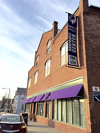
The Dudley Street Neighborhood Initiative, or DSNI, is a nonprofit, community-run organization based in Roxbury, Massachusetts. It was founded in 1984 by residents of the Dudley Street Neighborhood, along with members of the Riley Foundation, as an effort to rebuild the poverty-stricken community surrounding then-Dudley Square. It is known as the first and only community-run grassroots organization to gain "the power of eminent domain" by the Boston Redevelopment Authority, meaning the community controls its own development and the use of the land. Today, 35 board of directors help to govern the more than 3,000 active members of DSNI. The board of directors are elected by locals every two years, and must represent the community's four major ethnic groups: African American, Cape Verdean, Latino and White, as well as the local youth, businesses, nonprofits, churches and CDC's that support the initiative.
