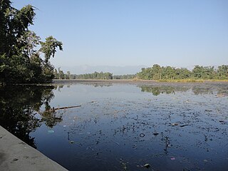
Gadariya is a village development committee in Kailali District in the Seti Zone of western Nepal. At the time of the 1991 Nepal census it had a population of 7355 living in 726 individual households.It has a main school named "Shree Janta Higher Secondary school."which is established in 2014 B.S.It has also a beautiful lake which name is Koilahee taal,and it is second biggest lake of Sudurpaschimanchal.
Basauti is a village development committee in Kailali District in the Seti Zone of western Nepal. At the time of the 1991 Nepal census it had a population of 4590 living in 544 individual households.

Bhajani is a Municipality in Kailali District in Sudurpashchim Pradesh of Nepal. At the time of the 2011 Nepal censusit had a population of 52,128. It is surrounded by Tikapur Municipality and Joshipur Rural Municipality in the East, Kailari Rural Municipality in the West, Ghodaghodi Municipality in the North and Tikunia, Uttar Pradesh in the South. It is divided into 9 wards.
Dododhara is a village development committee in Kailali District in the Seti Zone of western Nepal. At the time of the 1991 Nepal census it had a population of 8299 living in 1296 individual households.
Durgauli is a village development committee in Kailali District in the Seti Zone of western Nepal. At the time of the 1991 Nepal census it had a population of 9822 living in 1309 individual households.
Hasuliya is a village development committee in Kailali District in the Seti Zone of western Nepal. At the time of the 1991 Nepal census it had a population of 10638 living in 1405 individual households.
Khairala is a village development committee in Kailali District in the Seti Zone of western Nepal. At the time of the 1991 Nepal census it had a population of 3382 living in 541 individual households.
Masuriya is a village development committee in Kailali District in the Seti Zone of western Nepal. At the time of the 2011 Nepal census it had a population of 22017 living in 3828 individual households.
Mohanyal is a former village development committee that is now a Rural Municipality in Kailali District in Province No. 7 of western Nepal. At the time of the 1991 Nepal census it had a population of 3917 living in 614 individual households.
Munuwa is a village development committee in Kailali District in the Seti Zone of western Nepal. At the time of the 1991 Nepal census it had a population of 9276 living in 1173 individual households.
Narayanpur, Seti is a village development committee in Kailali District in the Seti Zone of western Nepal. At the time of the 1991 Nepal census it had a population of 9091 living in 1346 individual households.
Nigali is a village development committee in Kailali District in the Seti Zone of western Nepal. At the time of the 1991 Nepal census it had a population of 4480 living in 669 individual households.
Pahalmanpur is a village development committee in Kailali District in the Seti Zone of western Nepal. At the time of the 1991 Nepal census it had a population of 7155 living in 818 individual households.
Pandaun is a village development committee in Kailali District in the Seti Zone of western Nepal. At the time of the 1991 Nepal census it had a population of 3070 living in 536 individual households.
Pawera is a village development committee in Kailali District in the Seti Zone of western Nepal. At the time of the 1991 Nepal census it had a population of 4914 living in 538 individual households.
Ratnapur is a village development committee in Kailali District in the Seti Zone of western Nepal. At the time of the 1991 Nepal census it had a population of 5410 living in 506 individual households.
Sahajpur is a village development committee in Kailali District in the Seti Zone of western Nepal. At the time of the 1991 Nepal census it had a population of 5847 living in 987 individual households.
Sugarkhal is a village development committee in Kailali District in the Seti Zone of western Nepal. At the time of the 1991 Nepal census it had a population of 9599 living in 1634 individual households.
Thapapur is a village development committee in Kailali District in the Seti Zone of western Nepal. At the time of the 1991 Nepal census it had a population of 9909 living in 1295 individual households.
Udasipur is a village development committee in Kailali District in the Seti Zone of western Nepal. At the time of the 1991 Nepal census it had a population of 5320 living in 579 individual households.