Uzbekistan, officially the Republic of Uzbekistan, is a doubly landlocked country located in Central Asia. It is surrounded by five landlocked countries: Kazakhstan to the north; Kyrgyzstan to the northeast; Tajikistan to the southeast; Afghanistan to the south; and Turkmenistan to the south-west. Its capital and largest city is Tashkent. Uzbekistan is part of the Turkic world, as well as a member of the Organization of Turkic States. The Uzbek language is the majority-spoken language in Uzbekistan; other languages include the Russian language and the Tajik language. Islam is the predominant religion in Uzbekistan, most Uzbeks being Sunni Muslims.

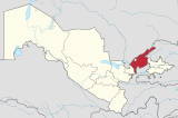
Qarshi is a city in southern Uzbekistan. It is the capital of Qashqadaryo Region. Administratively, Qarshi is a district-level city, that includes the urban-type settlement Qashqadaryo. It has a population of 278,300. It is about 520 km south-southwest of Tashkent, and about 335 km north of Uzbekistan's border with Afghanistan. It is located at latitude 38° 51' 48N; longitude 65° 47' 52E at an altitude of 374 meters. The city is important in natural gas production, but Qarshi is also famous for its production of woven flat carpets.

Kyrgyzstan, officially the Kyrgyz Republic, is a mountainous landlocked country in Central Asia. Kyrgyzstan is bordered by Kazakhstan to the north, Uzbekistan to the west, Tajikistan to the south, and the People's Republic of China to the east. Its capital and largest city is Bishkek. Ethnic Kyrgyz make up the majority of the country's six million people, followed by significant minorities of Uzbeks and Russians. The Kyrgyz language is closely related to other Turkic languages.

Khiva is a district-level city of approximately 93,000 people in Xorazm Region, Uzbekistan. According to archaeological data, the city was established around 1500 years ago. It is the former capital of Khwarezmia, the Khanate of Khiva, and the Khorezm People's Soviet Republic. Itchan Kala in Khiva was the first site in Uzbekistan to be inscribed in the World Heritage List (1991). The astronomer, historian and polymath, Al-Biruni was born in either Khiva or the nearby city of Kath.
Karakalpakstan, officially the Republic of Karakalpakstan, is an autonomous republic within Uzbekistan. It occupies the whole northwestern part of Uzbekistan. The capital is Nukus. The Republic of Karakalpakstan has an area of 166,590 km2 (64,320 sq mi), and a population of about two million. Its territory covers the classical land of Khwarezm, which in classical Persian literature was known as Kāt (کات).
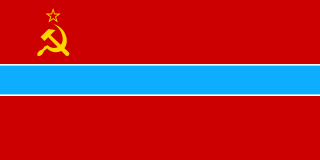
Uzbekistan is the common English name for the Uzbek Soviet Socialist Republic and later, the Republic of Uzbekistan, that refers to the period of Uzbekistan from 1924 to 1991 as one of the constituent republics of the Soviet Union. It was governed by the Uzbek branch of the Soviet Communist Party, the legal political party, from 1925 until 1990. From 1990 to 1991, it was a sovereign part of the Soviet Union with its own legislation. Sometimes, that period is also referred to as Soviet Uzbekistan.
The Karachays are a Turkic people of the North Caucasus, mostly situated in the Russian Karachay–Cherkess Republic.

Olmaliq is a district-level city in the Tashkent Region of central Uzbekistan, approximately 65 km east of Tashkent. It is located at latitude 40° 50' 41N; longitude 69° 35' 54E; at an altitude of 585 meters.

Termez is the capital of Surxondaryo Region in southern Uzbekistan. Administratively, it is a district-level city. Its population is 182,800 (2021). It is notable as the site of Alexander the Great's city Alexandria on the Oxus, as a center of Early Buddhism, as a site of Muslim pilgrimage, and as a base of Soviet Union military operations in Afghanistan, accessible via the nearby Hairatan border crossing.

Bukharian, also known as Judeo-Tajik, Judeo-Tadzhik, Bukhari, Bukharic, Bukharan and Bukharit, is the Judeo-Tajik dialect historically spoken by Bukharan Jews in Central Asia. It is a Jewish dialect derived from —and largely mutually intelligible with— the Tajik branch of the Persian language.

Krasnogorsk is a city and the administrative center of Krasnogorsky District in Moscow Oblast, Russia, located on the Moskva River, adjacent to the northwestern boundary of Moscow. Population: 116,896 (2010 Census); 92,545 (2002 Census); 90,477 (1989 Census).
Krasnogorsk may refer to one of the following:

National delimitation in the Union of Soviet Socialist Republics was the process of specifying well-defined national territorial units from the ethnic diversity of the Union of Soviet Socialist Republics (USSR) and its subregions. The Russian-language term for this Soviet state policy was razmezhevanie, which is variously translated in English-language literature as "national-territorial delimitation" (NTD), "demarcation", or "partition". National delimitation formed part of a broader process of changes in administrative-territorial division, which also changed the boundaries of territorial units, but was not necessarily linked to national or ethnic considerations. National delimitation in the USSR was distinct from nation-building, which typically referred to the policies and actions implemented by the government of a national territorial unit after delimitation. In most cases national delimitation in the USSR was followed by korenizatsiya (indigenization).

Philip Johan von Strahlenberg (1676–1747) was a Swedish officer and geographer of German origin who made important contributions to the cartography of Russia.

Soviet Central Asia was the part of Central Asia administered by the Soviet Union between 1918 and 1991, when the Central Asian republics declared independence. It is nearly synonymous with Russian Turkestan in the Russian Empire. Soviet Central Asia went through many territorial divisions before the current borders were created in the 1920s and 1930s.

Chełmsko Śląskie is a village in the administrative district of Gmina Lubawka, within Kamienna Góra County, Lower Silesian Voivodeship, in south-western Poland, near the border with the Czech Republic.

The Kirghiz Soviet Socialist Republic, also commonly known as the Kyrgyzstan and Soviet Kyrgyzstan in the Kyrgyz language and as Kirghizia and Soviet Kirghizia in the Russian language, was one of the constituent republics of the Soviet Union (USSR) from 1936 to 1991.
Angren is a district-level city in Tashkent Region, eastern Uzbekistan. The city is located on the Angren River 70 mi (110 km) to the east of Tashkent. The City of Angren was created in 1946 from the villages of Jigariston, Jartepa, Teshiktosh, and Qoʻyxona which had emerged in the rich Angren coal basin during World War II. It has an area of 150 km2 (58 sq mi) and the population of the city is 191,300 (2021).

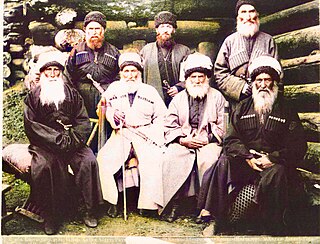
Photography in Uzbekistan started developing after 1882, when a Volga German photographer and schoolteacher named Wilhelm Penner moved to Khiva as a part of the Russian Mennonite migration to Central Asia led by Claas Epp, Jr. After his arrival in the Khanate of Khiva, Penner shared his photography skills with a local student Khudaybergen Divanov, who later became the founder of Uzbek photography.
Yevhen Rudakov club is an unofficial list of Soviet and Ukrainian football goalkeepers that have achieved 100 or more clean sheets during their professional career in top Soviet and Ukrainian league, cup, European cups, national team and foreign league and cup. This club is named after the first Soviet (Ukrainian) goalkeeper to achieve 100 clean sheets - Yevhen Rudakov.