Kroksund

Last updated
Kroksund and Sundvollen Kroksund-tb.jpg
Kroksund and Sundvollen
Kroksund bridge viewed from Kongens utsikt Hole in Norway.JPG
Kroksund bridge viewed from Kongens utsikt

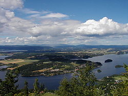
Kroksund is a small village in the municipality of Hole, in Buskerud, Norway.

Hole, Norway Municipality in Buskerud, Norway

Hole is a municipality in Buskerud county, Norway. It is part of the traditional region of Ringerike. The administrative centre of the municipality is the village of Vik. Hole is located around lake Tyrifjorden and extends to the woodland around Oslo. The soil is fertile and suited to growing fruit, berries and other agricultural products.

Buskerud County (fylke) of Norway

Buskerud is a county in Norway, bordering Akershus, Oslo, Oppland, Sogn og Fjordane, Hordaland, Telemark and Vestfold. The county extends from the Oslofjord and Drammensfjorden in the southeast to Hardangervidda mountain range in the northwest. The county administration is located in Drammen. Together with Akershus and Østfold, Buskerud will form the new, larger county Viken, from 1 January 2020.

Norway constitutional monarchy in Northern Europe

Norway, officially the Kingdom of Norway, is a Nordic country in Northern Europe whose territory comprises the western and northernmost portion of the Scandinavian Peninsula; the remote island of Jan Mayen and the archipelago of Svalbard are also part of the Kingdom of Norway. The Antarctic Peter I Island and the sub-Antarctic Bouvet Island are dependent territories and thus not considered part of the kingdom. Norway also lays claim to a section of Antarctica known as Queen Maud Land.

Kroksund is located just west of Sundvollen. The village had 319 residents as of 1 January 2014. European Route 16 passes over the Kroksundet sound on Steinsfjorden at Kroksund bridge which runs over the islands of Sundøya and Slettøya. Kongens utsikt situated across Steinsfjorden west of Kleivstua in Ringerike provides a panoramic view of both Kroksund and Kroksund bridge. [1] [2] [3] [4]

Sundvollen

Sundvollen is a village in the municipality of Hole, in the county of Buskerud, Norway. Sundvollen is located along the east side of Tyrifjorden where the E16 crosses west over Steinsfjorden, the northeastern arm of Tyrifjorden, to Kroksund. The village had 801 inhabitants as of January 2009.

Steinsfjorden fjord in Buskerud, Norway

Steinsfjorden is a branch of the lake Tyrifjorden located in Buskerud, Norway. It has a length of about eight kilometers, stretching from the sound Kroksund at Sundvollen northwards to Åsa, in the municipalities of Ringerike and Hole. At the eastern side are steep cliffs towards Krokskogen.

Ringerike (municipality) Municipality in Buskerud, Norway

Ringerike is a municipality in Buskerud county, Norway. It is part of the traditional region of Ringerike. The administrative centre of the municipality is the town of Hønefoss.

Related Research Articles

Hønefoss Unincorporated city in Buskerud, Norway

Hønefoss is a town and the administrative center of the municipality of Ringerike in Buskerud county, Norway. Hønefoss is an industrial center of inner Østlandet, containing several factories and other industry. As of 1 January 2008, Hønefoss has 14,177 inhabitants. In 1852, Hønefoss received town status and was separated from Norderhov. In 1964, Hønefoss ceased being a separate municipality and became part of Ringerike.

Tyrifjorden lake in Norway

Tyrifjorden is a lake in Norway. It lies 40 kilometres (25 mi) northwest of Oslo and is the nation's fifth largest lake with an area of 137 km2. It has a volume of 13 km3, is 295 meters deep at its deepest, and lies 63 meters above sea level. The lake's primary source is the Begna river, which discharges into Tyrifjorden at Hønefoss where the river forms the waterfall of Hønefossen. Its primary outlet is at Vikersund near the lake's southwest corner, where Tyrifjorden discharges into the Drammenselva river.

Skotselv Village in Østlandet, Norway

Skotselv is a village in the municipality of Øvre Eiker, Norway. Its population (2005) is 684, of which 8 people live within the border of the neighbouring municipality of Modum. It has a railway station on the Randsfjord Line.

Helgelandsmoen

Helgelandsmoen is a village located in Buskerud, Norway.

Åsa, Ringerike


Åsa is a village in Ringerike municipality in Buskerud, Norway. Åsa is located at the upper end of Steinsfjorden, the eastern branch of lake Tyrifjorden. The village stretches from Åsaporten, the first road tunnel towards Åsa from Norderhov, and around the north end and east side of the fjord area, south to the border with Hole.

Nakkerud is a small village in Ringerike municipality, Buskerud, Norway. Its population is 350.

Steinsåsen

Steinsåsen is a village in Hole municipality in Buskerud, Norway. Steinsåsen located on the west side of Steinsfjorden, the eastern arm of Tyrifjorden. The village is about 9 km southeast of Honefoss. European route E16 passes through Steinsåsen as it travels from Oslo to Bergen.

Norderhov

Norderhov is a former municipality located within Ringerike in Buskerud county, Norway.

Kykkelsrud is a village in Askim municipality, Norway. Located a few kilometres west of the town Askim, it is a part of the urban area of the same name, which has a population of 12,570. Kykkelsrud, located on the east bank of the Glomma river, has a power plant which harnesses the Kykkelsrud waterfall.

Haugsbygd

.

Jar, Norway Village in Østlandet, Norway

Jar is a district in the municipality of Bærum, Norway. Its population (2007) is 4,868.

Vik, Buskerud village and the administrative center of Hole in Buskerud, Norway


Vik is a village and the administrative center of Hole in Buskerud, Norway.

Ahmad Ghanizadeh is a Norwegian-Iranian politician for the Socialist Left Party. From 23rd March 2012 till 16th October 2013 he served as State Secretary in the Ministry of Children and Equality.

Norwegian National Road 7 road in Norway

Norwegian National Road 7 is a national road in Norway which runs from the town of Hønefoss in Buskerud county to the village of Granvin in Hordaland county. The route is 387.6 kilometres (240.8 mi) long and runs east–west through Buskerud and Hordaland counties over the vast Hardangervidda plateau.

References

Coordinates: 59°37′N11°35′E / 59.617°N 11.583°E / 59.617; 11.583

Geographic coordinate system Coordinate system

A geographic coordinate system is a coordinate system that enables every location on Earth to be specified by a set of numbers, letters or symbols. The coordinates are often chosen such that one of the numbers represents a vertical position and two or three of the numbers represent a horizontal position; alternatively, a geographic position may be expressed in a combined three-dimensional Cartesian vector. A common choice of coordinates is latitude, longitude and elevation. To specify a location on a plane requires a map projection.