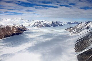
The Bastien Range is an Antarctic mountain range of moderate height which extends in a NW-SE direction for about 64 kilometres (40 mi), flanking the SW side of Nimitz Glacier and the Sentinel Range, in the Ellsworth Mountains.

Ferrar Glacier is a glacier in Antarctica. It is about 35 nautical miles long, flowing from the plateau of Victoria Land west of the Royal Society Range to New Harbour in McMurdo Sound. The glacier makes a right (east) turn northeast of Knobhead, where it where it is apposed, i.e., joined in Siamese-twin fashion, to Taylor Glacier. From there, it continues east along the south side of Kukri Hills to New Harbor.
Håøya is the main islet in Kulstadholmane, part of Thousand Islands, an island group south of Edgeøya, part of the Svalbard archipelago.

The Kongsvegen is a glacier, located in west Spitsbergen, Svalbard, 1,250 kilometres (780 mi) north of the Norwegian mainland.
The Worcester Range is a high coastal range, about 30 nautical miles long, in Antarctica. It stands between Skelton Glacier and Mulock Glacier on the western side of the Ross Ice Shelf.

Oscar II Land is the land area between Isfjorden and Kongsfjorden on Spitsbergen, Svalbard. The 30 km (19 mi) long glacier Sveabreen divides Oscar II Land from James I Land.

Sabine Land is a land area on the east coast of Spitsbergen, Svalbard. It is named after explorer General Sir Edward Sabine. Among the glaciers in the area is the 250-square-kilometer (97 sq mi) Nordmannsfonna glacier.

James I Land is a land area on the northwestern part of Spitsbergen, Svalbard. It is named after King James I of England and Scotland. The 30 kilometer long glacier Sveabreen divides James I Land from Oscar II Land.
Barentsjøkulen is a glacier on Barentsøya, Svalbard. The glacier covers an area of about 571 km2 (220 sq mi). It is named after the Barents Island, which again is named after Dutch explorer Willem Barentsz. Barents Island is on the Barents Sea.
Osbornebreen is a glacier in Oscar II Land at Spitsbergen, Svalbard, Norway. It has a length of 21 kilometers, merges with the glaciers Devikbreen, Klampebreen and Vintervegen, and debouches into St. Jonsfjorden. The mountain ridge Goldschmidtfjella forms a six kilometer long nunatak in the glacier.
Vintervegen is a glacier in Oscar II Land at Spitsbergen, Svalbard. It has a length of about 7.5 kilometers (4.7 mi). The glacier borders to the mountain of Klampen, merges with Osbornebreen and other glaciers, and the merged glacier stream debouches into the head of St. Jonsfjorden.
Rabotbreen is a glacier in Sabine Land at Spitsbergen, Svalbard. The glacier is a tributary glacier to Fimbulisen, and is located in the upper part of Sassendalen. Nearby mountains are Bairdfjellet and Moskusryggen.
Nansenbreen is a glacier in Oscar II Land at Spitsbergen, Svalbard. It has a length of about fourteen kilometers and is located west of Gestriklandkammen at the northwestern side of Isfjorden, debouching into the bay of Borebukta. It is named after Arctic explorer Fridtjof Nansen. The glacier exhibited a significant surge of about two kilometers in 1946, and has since gradually retreated.
Vegardbreen is a glacier in Oscar II Land at Spitsbergen, Svalbard. It has a length of about 5.5 kilometers, runs between Vegardfjella and Vittenburgfjella, and debouches into St. Jonsfjorden. The glacier is named after Norwegian physicist Lars Vegard.
Paulbreen is a glacier in Oscar II Land at Spitsbergen, Svalbard. It has a length of about four kilometers and is located at the eastern side of St. Jonsfjorden. The glacier is surrounded by Vittenburgfjella, and splits the range in a northern and southern part. The glacier, as well as the surrounding mountain range, is named after Russian paleontologist Paul Vittenburg.
Trollheimen is a mountainous area in Oscar II Land at Spitsbergen, Svalbard, around the glacier of Eidembreen. Among the mountains of Trollheimen are Tussekallen, Runebomma, Heksefjellet, Huldrefjellet, Huldrehatten, Tomtegubben, and parts of Gunnar Knudsenfjella. North of Eidembreen is the glacier of Huldrebreen, and to the south are Heksebreen and Stallobreen.
Heksebreen is a glacier in Oscar II Land at Spitsbergen, Svalbard. It has a length of about 3.5 kilometers, and is a tributary glacier to Eidembreen. The glacier is located south in the mountainous district of Trollheimen, and is surrounded by the mountains of Heksefjellet, Runebomma, Trollungen and Stortrollet.
Venernbreen is a glacier in Oscar II Land at Spitsbergen, Svalbard. It has a length of about fifteen kilometers, and is located between the mountains of Sparrefjellet and Kinnefjellet. The glacier is named after the Swedish lake of Vänern.
Huldrebreen is a glacier in Oscar II Land at Spitsbergen, Svalbard. It is surrounded by the mountains of Huldrehatten, Huldrefjellet and Bytingen, west in the mountainous district of Trollheimen. Huldrebreen and Austgötabreen are located north of the glacier complex of Eidembreen. The glacier is named after Hulder in Scandinavian folklore.


