Related Research Articles

The Hittites were an Anatolian Indo-European people who formed one of the first major civilizations of Bronze Age West Asia. Possibly originating from beyond the Black Sea, they settled in modern-day Turkey in the early 2nd millennium BC. The Hittites formed a series of polities in north-central Anatolia, including the kingdom of Kussara, the Kanesh or Nesha kingdom, and an empire centered on Hattusa. Known in modern times as the Hittite Empire, it reached its peak during the mid-14th century BC under Šuppiluliuma I, when it encompassed most of Anatolia and parts of the northern Levant and Upper Mesopotamia, bordering the rival empires of the Hurri-Mitanni and Assyrians.

The Hurrians were a people who inhabited the Ancient Near East during the Bronze Age. They spoke the Hurrian language, and lived throughout northern Syria, upper Mesopotamia and southeastern Anatolia.
Waššukanni or Aššukanni was the capital of the Hurrian kingdom of Mitanni, from around 1500 BC to the 13th century BC.

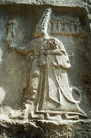
Muwatalli II was a king of the New Kingdom of the Hittite empire c. 1295–1282 and 1295–1272 BC in the short chronology.
Muršili III, also known as Urhi-Teshub, was a king of the Hittites who assumed the throne of the Hittite empire at Tarhuntassa upon his father's death. He was a cousin of Tudhaliya IV and Queen Maathorneferure. He ruled ca. 1282–1275 BC or 1272–1265 BC.
Šarruma, also romanized as Šarrumma or Sharruma, was a Hurrian god. He could be depicted in both anthropomorphic form, sometimes riding on the back of a leopard, and in the theriomorphic form as a bull. His character is not fully understood, though it is known that he could function as a mountain god. He was regarded as a son of Ḫepat and Teshub. He was also linked to various moon deities. Additionally, the only mythological text he appears in addresses him as a messenger (sukkalu) of Kumarbi. He was worshiped by Hurrians in southeastern Anatolia and northern Syria, for example in Kummanni and Lawazantiya in Kizzuwatna. From this kingdom he was introduced to the Hittite pantheon as well. Hittite influence in turn resulted in his introduction to cities such as Aleppo, Emar and Ugarit. He was also venerated in Luwian religion in the first millennium BCE, with theophoric names invoking him attested from as late as the Hellenistic period in Cilicia and Lycia.

Nikkal or Nikkal-wa-Ib was a goddess worshiped in various areas of the ancient Near East west of Mesopotamia. She was derived from the Mesopotamian goddess Ningal, and like her forerunner was regarded as the spouse of a moon god, whose precise identity varied between locations. While well attested in Hurrian and Hittite sources, as well as in Ugarit, she is largely absent from documents from the western part of ancient Syria.
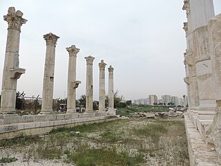
Soli, often rendered Soli/Pompeiopolis, was an ancient city and port in Cilicia, 11 km west of Mersin in present-day Turkey.
Manuzi was a mountain god worshiped in Kizzuwatna. He shared his name with the mountain he represented and with a village. He is best attested from sources pertaining to the hišuwa festival, which indicate he was the husband of the goddess Lelluri. He could be identified as a form of the Hurrian weather god Teshub as well, and as such was referred to as Teshub Manuzi.

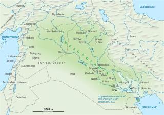
Kizzuwatna was an ancient Anatolian kingdom, attested in written sources from the end of the 16th century BC onwards, but though its origins are still obscure, the Middle Bronze Age in Cilicia can be seen as its possible formative period. Kisuwatna was situated mostly in the Cilician Plain of southeastern Anatolia, near the Gulf of İskenderun, in modern-day Turkey. The Central Taurus Mountains and the Amanus Mountains encircled it. The centre of the kingdom was the city of Kummanni, in the highlands.
Çukurova or the Cilician Plain, is a large fertile plain in the Cilicia region of southern Turkey. The plain covers the easternmost areas of Mersin Province, southern and central Adana Province, western Osmaniye Province and northwestern Hatay Province.
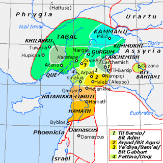
Ḫiyawa or Adanawa was a Luwian-speaking Syro-Hittite state which existed in southeastern Anatolia in the Iron Age.

Šamuḫa is an ancient Bronze Age settlement near the village of Kayalıpınar, Yıldızeli, c. 40 km west of Sivas, in the Sivas Province of Turkey. Located on the northern bank of Kizil Irmak river, it was a city of the Hittites, a religious centre and, for a few years, a military capital for the empire. Samuha's faith was syncretistic. Rene Lebrun in 1976 called Samuha the "religious foyer of the Hittite Empire".
The Luwians were an ancient people in Anatolia who spoke the Luwian language. During the Bronze Age, Luwians formed part of the population of the Hittite Empire and adjoining states such as Kizzuwatna. During the Hittite New Kingdom, Luwian replaced Hittite as the empire's dominant language. In the early Iron Age, a number of Luwian-speaking Neo-Hittite states arose in northern Syria. The Luwians are known largely from their language, and it is unclear to what extent they formed a unified cultural or political group.
Kumme was a Hurrian city, known from textual sources from both second and first millennium BCE. Its precise location is unknown, but it is mentioned in cuneiform texts from multiple other sites. It might have been located close to modern Zakho or Beytüşşebap. From the Old Babylonian period until Neo-Assyrian times it served as a religious center of transregional significance due to its association with the Hurrian weather god, Teshub. Its religious role is first mentioned in texts from Mari, and later recurs in Hurrian and Hittite sources. In the Neo-Assyrian period, it was apparently the center of a small independent buffer state on Assyrian borders. Its ultimate fate remains unknown, as from the reign of Sennacherib onward it is no longer mentioned in any texts.
Urshu, Warsuwa or Urshum was a Hurrian-Amorite city-state in southern Turkey, probably located on the west bank of the Euphrates, and north of Carchemish.
Lawazantiya was a major Bronze Age city in the Kingdom of Kizzuwatna and the cultic city of the goddess Šauška. It was famous for its temple that got purification water from its seven springs. Today the best candidate for the site is Tatarli Höyük which is known for its seven springs.
Volkert Haas was a German Assyrologist and Hittitologist.
Tynna, possibly also known as Dana, was an ancient Anatolian city located at the foothills of the Taurus Mountains, near the town of Ulukışla and the Cilician Gates in southern Cappadocia.

Sirkeli Höyük is one of the largest tells of Cilicia with an area of approximately 80 ha. It is 40 kilometers east of the city of Adana, northwest of the village Sirkeli in the district of Ceyhan, at the breakthrough of the Ceyhan through the Misis Mountains.
References
- ↑ "Kummanni." Reallexikon der Assyriologie.
- ↑ 'Forlanini, M. 2013: How to infer Ancient Roads and Intineraries from heterogenous Hittite Texts: The Case of the Cilician (Kizzuwatnean) Road System, KASKAL 10, 1–34.
- ↑ Kozal, Ekin; Novák, Mirko (2017), Facing Muwattalli: Some Thoughts on the Visibility and Function of the Rock Reliefs at Sirkeli Höyük, Cilicia, vol. 445, Ugarit-Verlag, pp. 373–390, doi:10.7892/BORIS.106777, ISBN 9783868352511 , retrieved 2022-06-17
- Ernest René Lacheman, Martha A. Morrison, David I. Owen, General studies and excavations at Nuzi 9/1, 1987, ISBN 978-0-931464-08-9, p. 50f.
- Massimiliano Forlanini, How to infer Ancient Roads and Intineraries from heterogenous Hittite Texts: The Case of the Cilician (Kizzuwatnean) Road System, KASKAL 10, 2013, 1–34.
- Mirko Novák and Susanne Rutishauser, Kizzuwatna: Archaeology, in: M. Weeden und L.Z. Ullmann (ed.), Hittite Landscape and Geography, Leiden 2017, 134–145.