
At 824,292 km2 (318,261 sq mi), Namibia is the world's thirty-fourth largest country. After Mongolia, Namibia is the second least densely populated country in the world. Namibia got its name from the Namib desert that stretches along the coast of the Atlantic. It is also known for its wildlife.

Omusati is one of the fourteen regions of Namibia, its capital is Outapi. The towns of Okahao, Oshikuku and Ruacana as well as the self-governed village Tsandi are situated in this region. As of 2020, Omusati had 148,834 registered voters.

Kunene is one of the fourteen regions of Namibia. Its capital is Opuwo, its governor is Marius Sheya. The region's name comes from the Kunene River which forms the northern border with Angola. Besides the capital Opuwo, the region contains the municipality of Outjo, the town Khorixas and the self-governed village Kamanjab. Kunene is home to the Himba people, a subtribe of the Herero, as well as to Damara people and Nama people. As of 2020, Kunene had 58,548 registered voters.

Cunene is a province of Angola. It has an area of 87,342 km2 and a population of 990,087 in 2014.

The Cunene or Kunene is a river in Southern Africa. It flows from the Angola highlands southwards to the border with Namibia. It then flows in a westerly direction along the border until it reaches the Atlantic Ocean.
Kaokoland was an administrative unit and a bantustan in northern South West Africa. Established in 1980 during the apartheid era, it was intended to be a self-governing homeland of the Ovahimba, but an actual government was never established, and the territory was administered by the leaders of Hereroland. Like other homelands in South West Africa, the Kaokoland bantustan was abolished in May 1989, at the beginning of the transition of Namibia towards independence.
Iona National Park is the largest and oldest national park in Angola. It is situated in the Southwestern corner of the country, in Namibe Province. It is roughly bound by the Atlantic Ocean to the West, an escarpment to the East that marks the beginning of the interior plateau, the Curoca River to the North, and the Cunene River to the South. It is about 200 kilometres (120 mi) south of the city of Namibe and covers 5,850 square miles (15,200 km2) sq. miles.
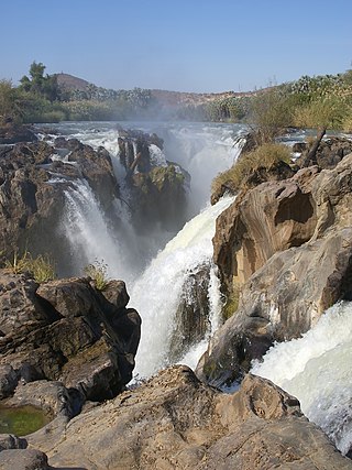
Epupa Falls is a series of large waterfalls formed by the Cunene River on the border of Angola and Namibia, in the Kaokoland area of the Kunene Region. The river is about 0.5 kilometres (1,600 ft) wide in this area and drops in a series of waterfalls across a length of 1.5 kilometres (0.93 mi), with the greatest single drop being 37 metres (121 ft) in height. The settlement near the falls is also called Epupa.

Calueque is a town next to a dam and pumping station of the same name on the Kunene River in the Kunene Province of southern Angola. The water project is linked to Ruacana, 20 km (12 mi) away in Namibia, where the Ruacana Power Station is. This dam is one of the last landmarks along the Kunene River, prior to the Kunene becoming a border feature between Angola and Namibia. A 300 km (190 mi) pipeline and canal extends across the border into Namibia, supplying towns as far away as Oshakati in Ovamboland with water. The dam was completed in 1976. However, due to the onset of the Angolan civil war following independence, the full master plan for the scheme was not realised by the South African and Portuguese governments.

Angola is located on the western Atlantic Coast of Southern Africa between Namibia and the Republic of the Congo. It also is bordered by the Democratic Republic of the Congo and Zambia to the east. The country consists of a sparsely watered and somewhat sterile coastal plain extending inland for a distance varying from 50 to 160 km. Slightly inland and parallel to the coast is a belt of hills and mountains and behind those a large plateau. The total land size is 1,246,700 km2 (481,400 sq mi). It has an Exclusive Economic Zone of 518,433 km2 (200,168 sq mi).
The Calueque Dam, is an operational multipurpose dam across the Kunene River, in Kunene Province, in southwestern Angola. The dam stores water for the 347 MW (465,000 hp) Ruacana Hydroelectric Power Station, in neighboring Namibia. Its waters are also used for the irrigation of farmland, both in Angola and Namibia.

The 2009 Angola, Namibia and Zambia floods was a natural disaster which began in early March 2009 and resulted in the deaths of at least 131 people and otherwise affected around 445,000 people. The floods affected seven regions of Namibia, three provinces of Zambia, two regions of Angola and part of Botswana. The floodwaters damaged buildings and infrastructure and displaced at least 300,000 people. A state of emergency was declared in northern Namibia and there were fears that a disease epidemic would ensue. The Red Cross agencies and governments of the two countries responded to the disaster, and aid was distributed be the World Health Organization.
Namacunde or Namakunde is a town and municipality in Cunene Province in Angola. The municipality had a population of 142,047 in 2014.

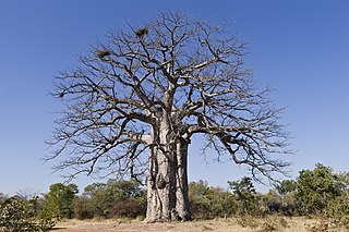
Angolan mopane woodlands are situated in southwestern Angola, extending into northern Namibia. This ecosystem surrounds Etosha Pan, which is considered a separate ecoregion. The mopane trees are the main type of vegetation.

The Ruacana Hydroelectric Power Station is a hydroelectric power plant near Ruacana in northwest Namibia, close to the Angolan border. Commissioned in 1978, it is by far the largest power station in Namibia. Its operator is NamPower, the Namibian national electric power utility company.

The Cunene labeo or Kunene labeo is a species of fish in the family Cyprinidae, the carps and minnows. It is native to Angola and Namibia.
The Mbadja or Ovambadja is an independent Bantu tribe that speaks the Oshimbadja language. The tribe consider themselves to be a distinct ethnic group, and the Namibian government formally recognised them in 2002. They originate from Ombadja in southern Angola, Cunene Province.

The Owambo Basin is a sedimentary basin located on the Congo Craton in Southern Africa that extends from southern Angola into Namibia and includes the Etosha Pan. It is bound on the southern and western sides by the Damara Belt in Northern Namibia, and by the Cubango River to the East. The northern boundary is scientifically disputed, but is currently mapped by most stratigraphers to include southern Angola with the boundary set at the Kunene River. The Owambo Basin is host to two famous regions: Tsumeb, a major Namibian city and site of a formerly active copper mine with exceptional mineralogical variability producing museum quality rare specimens, and Etosha National Park, the largest protected wildlife sanctuary in Namibia centered around Etosha Pan.
The Baynes Mountains are a mountain range in Namibia.