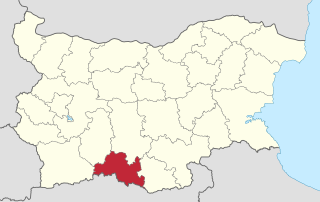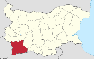
Blagoevgrad Province, also known as Pirin Macedonia is a province (oblast) of southwestern Bulgaria. It borders four other Bulgarian provinces to the north and east, to the Greek region of Macedonia to the south, and North Macedonia to the west. The province has 14 municipalities with 12 towns. Its principal city is Blagoevgrad, while other significant towns include Bansko, Gotse Delchev, Melnik, Petrich, Razlog, Sandanski, and Simitli.

Kardzhali District is a province of southern Bulgaria, neighbouring Greece with the Greek regional units of Xanthi, Rhodope, and Evros to the south and east. It is 3209.1 km² in area. Its main city is Kardzhali.

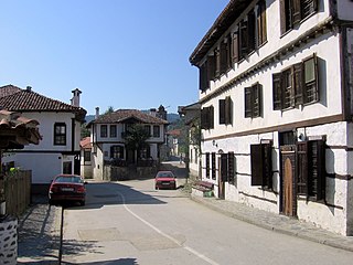
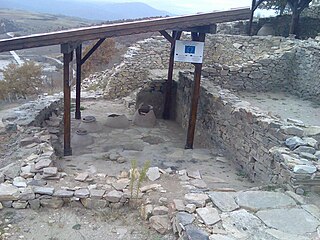
Gotse Delchev, is a town in Gotse Delchev Municipality in Blagoevgrad Province of Bulgaria with a population of 20,522.

Western Thrace or West Thrace is a geographic and historical region of Greece, between the Nestos and Evros rivers in the northeast of the country; East Thrace, which lies east of the river Evros, forms the European part of Turkey, and the area to the north, in Bulgaria, is known as Northern Thrace.

Svilengrad is a town in Haskovo Province, south-central Bulgaria, situated at the border of Turkey and Greece. It is the administrative centre of the homonymous Svilengrad Municipality. As of December 2009, the town has a population of 18,132 inhabitants.
Kirkovo is a village in Kardzhali Province, southern Bulgaria, near the Greek border.
Chernichevo is a village in southern Bulgaria, located in the municipality of Krumovgrad in the Kardzhali Province. It is situated in the Eastern part of Rhodope Mountains, near the border with Greece. Its original Bulgarian name is "Dunyata". The correct geographical location of Chernichevo is 41° 21' N, 25° 47' E.
Kapitan Andreevo is a village in Svilengrad municipality, Haskovo Province, southern Bulgaria. As of 2005 it has 948 inhabitants and the mayor is Dimitar Shiderov. Due to the proximity with Turkey, there is a major border checkpoint built there, with the Turkish side of the checkpoint being called Kapıkule. The busy Bulgaria–Turkey border crossing at Kapitan Andreevo is an important point of entrance to the European Union. Kapitan Andreevo is located at 41°43′N26°19′E, 30 metres above sea level. It was known as "Virantekke" during Ottoman rule.
Hadzhidimovo is a small town and the centre of Hadzhidimovo Municipality in Blagoevgrad Province, south-western Bulgaria.

Kresna is a town and the seat of Kresna Municipality in Blagoevgrad Province in Bulgaria.
Pachni is a settlement in the Xanthi regional unit of Greece, part of the municipal unit Kotyli. Greek foreign affairs minister Dora Bakoyannis visited the village during her tour of Thrace.

Ormenio is the northernmost place in all of Greece. It is part of the municipal unit of Trigono in the Evros regional unit of Thrace. It is situated near the right bank of the river Evros, which forms the border with Bulgaria here. On the other side of the Evros, 6 km to the north, lies the Bulgarian town Svilengrad. Nearby villages in Greece are Ptelea to its southeast and Petrota to its southwest. Ormenio is bypassed by the Greek National Road 51/European route E85, which continues across the border as the Bulgarian road 80 to Svilengrad. Ormenio had a railway station on the line from Didymoteicho to Harmanli in Bulgaria. During the Ottoman era, Ormenio was called Çirmen in Turkish. After the Balkan Wars it was ceded to Bulgaria as Chernomen.
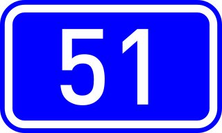
Greek National Road 51 is a single carriageway road in northeastern Greece. It connects the Greek National Road 2 near Feres with the Bulgarian border near Ormenio. The main towns on the GR-51 are Didymoteicho and Orestiada. The entire GR-51 is part of the European route E85. Its length is about 128 km. It runs from south to north, parallel to the river Evros.
Lyalevo or Lyalyovo is a former village in southernmost western Bulgaria which ceased to exist in 1960. Lyalevo is known as the only village within the modern borders of Bulgaria that was inhabited by Greek Muslims (Vallahades).
Lehovo is a village in the municipality of Sandanski, in Blagoevgrad Province, southwestern Bulgaria.
Makaza, previously also known as Balkan Toresi, is a mountain pass in the Eastern Rhodope Mountains, connecting southernmost central Bulgaria with north-easternmost Greece and thus the regions of Northern and Western Thrace. The Makaza pass forms part of Pan-European Corridor IX, connecting Helsinki in Finland with the Greek port of Alexandroupolis on the Aegean Sea. The international border between Bulgaria and Greece lies at the highest point of the pass, at 682 metres (2,238 ft) above sea level.

Devoll is a municipality in Korçë County, southeastern Albania. It was created in 2015 by the merger of the former municipalities Bilisht, Hoçisht, Miras, Progër and Qendër Bilisht. The seat of the municipality is the town Bilisht. The total population is 26,716, in a total area of 453.27 km2. It derives its name from the Devoll river flowing through the valley. It had a population of 33,785, and an area of 429 km². It is in the southeastern corner of the country, and its capital is Bilisht. Its busy border point Kapshticë/Krystallopigi connects the district with the Greek regional units of Florina and Kastoria to the east and southeast. Devoll borders the district of Kolonjë to the southwest and Korçë to the west and north. It is coterminous with the former Devoll District, which had the five subunits of Bilisht, Hoçisht, Miras, Progër and Qendër Bilisht, with the capital in the town of Bilisht. Devoll is also considered a traditional or "ethnographic" region with borders similar to the former district.
Golyamo Kamenyane is a village in Krumovgrad Municipality, Kardzhali Province, southern Bulgaria.

Vathylakkos is in the Drama Prefecture in northern Greece.