Related Research Articles

Suriname or Surinam, officially known as the Republic of Suriname, is a country on the northeastern Atlantic coast of South America. It is bordered by the Atlantic Ocean to the north, French Guiana to the east, Guyana to the west, and Brazil to the south. At just under 165,000 square kilometers, it is the smallest sovereign state in South America.

Brokopondo is a district of Suriname. Its capital city is Brokopondo; other towns include Brownsweg and Kwakoegron.

Para is a district of northern Suriname. Para's capital city is Onverwacht, with other towns including Paranam, and Zanderij. Para has a population of 24,700 and an area of 5,393 km2. The district is the mining and forestry centre of Suriname, with many large bauxite mining operations operating. The district is a mixture of forest and savannas.

Wanica is a district of Suriname located in the north of the country. Wanica's capital city is Lelydorp, the second-largest city in Suriname. Wanica has a population of 118,222 and an area of 443 km2. Following neighbouring Paramaribo, Wanica is the second most populated and urbanised district of Suriname. Two-thirds of the country's population live in these two districts.
Surinam Airways, also known by its initials SLM, is the flag carrier of Suriname, based in Paramaribo. It operates regional and long-haul scheduled passenger services. Its hub is at Johan Adolf Pengel International Airport (Zanderij). Surinam Airways is wholly owned by the Government of Suriname.

Nieuw Nickerie is the third largest city in Suriname with a population estimated at 12,818. It is the capital city of the Nickerie district, and the terminus of the East-West Link.

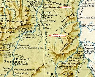
Brokopondo is the capital town of the Brokopondo District, Suriname. It is located on the west shore of the Suriname river, just north of the Afobaka dam. Brokopondo can be reached via the Afobakaweg from Paranam to Afobaka.
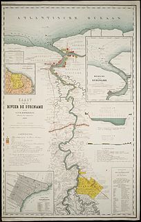
The Suriname River is 480 km long and flows through the country Suriname. Its sources are located in the Guiana Highlands on the border between the Wilhelmina Mountains and the Eilerts de Haan Mountains. The river flows below the reservoir along Brokopondo, Berg en Dal, the migrant communities Klaaskreek and Nieuw-Lombé, Jodensavanne, Carolina, Ornamibo and Domburg, before reaching the capital Paramaribo on the left bank and Meerzorg on the right bank. At Nieuw-Amsterdam it is joined by the Commewijne and immediately thereafter at the sandspit Braamspunt it flows into the Atlantic Ocean.
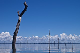
The Brokopondo Reservoir, officially named Professor Doctor Ingenieur W. J. van Blommestein Meer, and also called the Brokopondostuwmeer, is a large reservoir in Suriname. It is named after the Surakarta-born Dutch hydrological engineer Willem Johan van Blommestein. With a surface area of approximately 1,560 km2 (600 sq mi), depending on the current water level, it is one of the largest reservoirs in the world, covering nearly one percent of the country.

Brownsweg is a town and resort in Suriname in the Brokopondo District. Its population at the 2012 census was 4,793.

Centrum is a resort in Suriname, located in the Brokopondo District. Its population at the 2012 census was 4,482. Centrum can be reached by car via the Afobakaweg from Paranam to Afobaka, or by boat via the Suriname River.

Klaaskreek is a resort in Suriname, located in the Brokopondo District. Its population at the 2012 census was 2,124. Located northeast of Brokopondo, the main town is Reinsdorp. In 2007, a technical training centre in biological agriculture was established at Klaaskreek to teach locals about enhancing agriculture in the area.

Brownsberg Nature Park is a nature park located in Suriname. The site measures 12,000 ha and is located in the district of Brokopondo around 130 km south from the capital city Paramaribo. The 500 meter high Brownsberg is the central point of the park. The site is located near the Brokopondo Reservoir. The park is managed by STINASU. Often the people of Suriname use the word Brownsberg as simple variant of Brownsberg Nature Park. Local people also write it as Bruijnsberg, pronounced as Braynsberg.

Stoelmanseiland is an island, and a village in the Paramacca resort of the Sipaliwini District. It is located at the confluence of the Tapanahony River with the Lawa River which forms the Marowijne River, and is also the border with French Guiana.

Pamacca is a resort in Suriname, located in the Sipaliwini District. The population is estimated between 1,500 and 2,000 people. In 1983, the Sipaliwini District was created, and the eastern part became the resort of Tapanahony. The Pamacca resort is the northern part of Tapanahony, and mainly inhabited by the Paramaccan people, the border of the resorts is the island of Bofoo Tabiki in the Marowijne River.
Jaw Jaw, also Yaw Yaw, is a village of Saamaka Maroons in the Boven Suriname resort of the Sipaliwini District of Suriname. The village is located on the Suriname River.

Stoneiland (also Ston Island is a peninsula, holiday resort and beach in the Brokopondo District in Suriname.
Sara Creek is a former tributary of the Suriname River located in the Para District of Suriname. After the completion of the Afobaka Dam in 1964, the Sara Creek flows into the Brokopondo Reservoir. In 1876, gold was discovered along the Sara Creek, and a railway line from Paramaribo to the river was completed in 1911.
Nieuw-Lombe is a village in the resort of Klaaskreek in the Brokopondo District of Suriname. The village is located on the Suriname River, and is inhabitated by Saramaka maroons. Nieuw-Lombe is a transmigration village built for the inhabitants of Lombé which was flooded by the Brokopondo Reservoir after the construction of the Afobaka Dam.
References
- ↑ "Suriname Total Adventure Tours | Kwana eiland". Archived from the original on 2011-08-30. Retrieved 2011-04-22.
- ↑ ".: Sudamérica, Surinam, Distrikt Brokopondo, Distrikt Brokopondo – Lugares recónditos del mundo | Mapas, fotografias, videos, efemérides, celebridades, comentarios y accidentes geográficos. Sudamérica, Surinam, Distrikt Brokopondo, Distrikt Brokopondo". Archived from the original on 2012-03-16. Retrieved 2011-04-22.
- ↑ "Kwana Eiland". Kwana Eiland via Facebook (in Dutch). Retrieved 29 May 2020.