
The Arctic Archipelago, also known as the Canadian Arctic Archipelago, is an archipelago lying to the north of the Canadian continental mainland, excluding Greenland and Iceland.

The Mid-Atlantic Ridge is a mid-ocean ridge located along the floor of the Atlantic Ocean, and part of the longest mountain range in the world. In the North Atlantic, the ridge separates the North American from the Eurasian Plate and the African Plate, north and south of the Azores Triple Junction. In the South Atlantic, it separates the African and South American plates. The ridge extends from a junction with the Gakkel Ridge northeast of Greenland southward to the Bouvet Triple Junction in the South Atlantic. Although the Mid-Atlantic Ridge is mostly an underwater feature, portions of it have enough elevation to extend above sea level, for example in Iceland. The ridge has an average spreading rate of about 2.5 centimetres (1 in) per year.

Argentine Antarctica is an area on Antarctica claimed by Argentina as part of its national territory. It consists of the Antarctic Peninsula and a triangular section extending to the South Pole, delimited by the 25° West and 74° West meridians and the 60° South parallel. This region overlaps with British and Chilean claims in Antarctica. None of these claims have widespread international recognition.
The Aviator Glacier is a major valley glacier in Antarctica that is over 60 nautical miles long and 5 nautical miles wide, descending generally southward from the plateau of Victoria Land along the west side of Mountaineer Range, and entering Lady Newnes Bay between Cape Sibbald and Hayes Head where it forms a floating tongue.
Borchgrevink Glacier is a large glacier in the Victory Mountains, Victoria Land, Antarctica. It drains south between Malta Plateau and Daniell Peninsula, and thence projects into Glacier Strait, Ross Sea, as a floating glacier tongue.

The French Antarctic Expedition is any of several French expeditions in Antarctica.
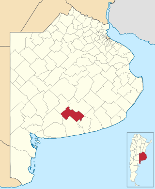
Adolfo Gonzales Chaves is a partido of Buenos Aires Province in Argentina, it is located at coordinates 38°02′S60°05′W.
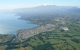
Toltén River is a river located in the La Araucanía Region of Chile. It rises at Villarrica Lake, close to the city of the same name. Its major tributary is the Allipén River. From its confluence with the Allipén, the river follows a braided course.

Calzadilla de Tera is a municipality located in the province of Zamora, Castile and León, Spain. According to the 2004 census (INE), the municipality has a population of 467 inhabitants.
Alamein Range is a range lying west of Canham Glacier, in the Freyberg Mountains of Antarctica. It was named in association with Lord Bernard Freyberg and the Second New Zealand Expeditionary Force by the Northern Party of New Zealand Geological Survey Antarctic Expedition (NZGSAE), 1963–64.

Dinsmoor Glacier is a glacier in the Nordenskjöld Coast of Antarctica, named for inventor Charles Dinsmoor. It flows east from the Detroit Plateau, and merges with the Edgeworth Glacier near Mount Elliott before draining into Mundraga Bay.
Angossas is a town and commune in Cameroon.
Quixeré is a municipality in the state of Ceará in the Northeast region of Brazil.
Barnett Glacier is a large glacier in the Anare Mountains that flows east along the south side of Tapsell Foreland into Smith Inlet, northern Victoria Land, Antarctica.
Blanchard Glacier is a glacier flowing into Wilhelmina Bay between Garnerin Point and Sadler Point, on the west coast of Graham Land. First charted by the Belgian Antarctic Expedition under Gerlache, 1897–99, it was named by the UK Antarctic Place-Names Committee in 1960 for Jean-Pierre Blanchard (1753–1809), French aeronaut, the first professional balloon pilot, who, with John Jeffries, made the first balloon crossing of the English Channel in 1785.

Dobbratz Glacier is a broad tributary glacier which drains the south part of the White Escarpment and flows northeast between the Watlack Hills and the Webers Peaks into Splettstoesser Glacier, in the Heritage Range. It was named by the University of Minnesota Geological Party, 1963–64, for Major Joseph Dobbratz, a United States Marine Corps pilot who supported the party.
Sayce Glacier is a glacier flowing into Flandres Bay immediately north of Pelletan Point, on the west coast of Graham Land. Charted by the Belgian Antarctic Expedition under Gerlache, 1897–99. Named by the United Kingdom Antarctic Place-Names Committee (UK-APC) in 1960 for B.J. Sayce (1839–1895), English photographer who, with W.B. Bolton, invented the collodion emulsion process of dry plate photography, which displaced wet collodion in 1864.

Río Bravo Municipality is one of the municipalities in the Mexican state of Tamaulipas. The seat is at Río Bravo, Tamaulipas.
