
The Arctic Archipelago, also known as the Canadian Arctic Archipelago, is an archipelago lying to the north of the Canadian continental mainland, excluding Greenland and Iceland.

Ottawa County is a county located in the U.S. state of Kansas. Its county seat and largest city is Minneapolis. As of the 2020 census, the county population was 5,735. The county was named after the Odawa tribe.

Brazilian Antarctica is the Antarctic territory south of 60°S, and from 28°W to 53°W, proposed as "Zone of Interest" by geopolitical scholar Therezinha de Castro. While the substance of that designation has never been precisely defined, it does not formally contradict the Argentine and British claims geographically overlapping with that zone. The country formally expressed its reservations with respect to its territorial rights in Antarctica when it acceded to the Antarctic Treaty on 16 May 1975, making the first official mention of the Frontage Theory, which states (simplified) that sovereignty over each point in Antarctica properly belongs to the first country whose non-Antarctic territory one would reach when travelling north in a straight line from such a point. The Frontage Theory was proposed by Brazilian geopolitical scholar Therezinha de Castro and published in her book Antártica: Teoria da Defrontação.
The Stikine Ranges are a group of mountain ranges and mountainous plateaus in northwestern British Columbia, Canada. They are the northernmost subdivision of the Cassiar Mountains and among the least explored and most undeveloped parts of the province.

Machadinho is a municipality in the state of Rio Grande do Sul, Brazil. It was raised to municipality status in 1959, the area being taken out of the municipality of Lagoa Vermelha. As of 2020, the estimated population was 5,427.
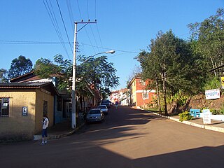
Porto Mauá is a municipality in the state of Rio Grande do Sul, Brazil. As of 2020, the estimated population was 2,352.
Redentora is a municipality in the state of Rio Grande do Sul, Brazil. As of 2020, the estimated population was 11,669.
Tsinjomitondraka is a town and commune in Madagascar. It belongs to the district of Boriziny, which is a part of Sofia Region. The population of the commune was estimated to be approximately 11,000 in 2001 commune census.
Ironside Glacier is a glacier, about 30 mi (48 km) long, originating at the south side of Mount Minto in the Admiralty Mountains and draining southeast between Mount Whewell and Mount Herschel into Moubray Bay, Victoria Land, Antarctica. At its mouth it is joined by the Honeycomb Glacier flowing in from the north.

Telefon Bay is a small bay on the north-west coast of Port Foster, Deception Island, in the South Shetland Islands of Antarctica. It is surmounted by Telefon Ridge. The name appears on the chart of the French Antarctic Expedition under Charcot, 1908–10.
The Land Glacier is a broad, heavily crevassed glacier, about 35 nautical miles (60 km) long, descending into Land Bay in Marie Byrd Land, Antarctica. It was discovered by the U.S. Antarctic Service (1939–41) and named for Rear Admiral Emory S. Land, Chairman of the U.S. Maritime Commission.
Toumour is a village and rural commune in Niger located near the Niger–Nigeria border. As of 2011, the commune had a total population of 1336 people.
Escoma is a location in the La Paz Department in Bolivia. It is the seat of the Escoma Municipality, one of five municipalities of the Eliodoro Camacho Province. In 2009 Escoma had an estimated population of 712.
Cape Hansen is a cape which separates Marshall Bay and Iceberg Bay on the south coast of Coronation Island, in the South Orkney Islands, Antarctica. The name appears on a chart based upon a running survey of the islands in 1912–13 by Petter Sørlle, a Norwegian whaling captain.
The Havre Mountains are a large group of mountains forming the northwestern extremity of Alexander Island, Antarctica, extending 20 nautical miles (37 km) in an east–west direction between Cape Vostok and the Russian Gap. They were first seen in 1821 by a Russian expedition under Fabian Gottlieb von Bellingshausen and re-sighted by the Belgian Antarctic Expedition, 1897–99. They were roughly charted by the French Antarctic Expedition, 1908–10, under Jean-Baptiste Charcot, who named them for Le Havre, the French port from which the Pourquol Pas? sailed in 1908. The mountains were mapped in detail from air photos taken by the Ronne Antarctic Research Expedition, 1947–48, by D. Searle of the Falkland Islands Dependencies Survey in 1960.
Aaron Glacier is a 4-mile (6.4 km) long Antarctic glacier which drains between the Janulis Spur and the Gray Spur in the Thiel Mountains. The name was proposed by Peter Bermel and Arthur B. Ford, co-leaders of the U.S. Geological Survey (USGS) Thiel Mountains party from 1960 to 1961. It was named for John M. Aaron, a USGS geologist and member of the 1960–61 and 1961–62 field parties to the Thiel Mountains.
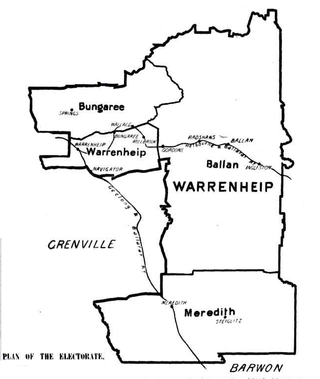
The electoral district of Warrenheip was an electorate of the Victorian Legislative Assembly in the British colony, and later Australian state, of Victoria. Created in 1889, the electorate was abolished in 1927 when it became the electoral district of Warrenheip and Grenville.
Crater Lake is a volcanic crater, now filled with water, lying north-west of Mount Kirkwood on the south side of Deception Island, in the South Shetland Islands of Antarctica. The descriptive name was given by the United Kingdom Antarctic Place-Names Committee (UK-APC) in 1959.