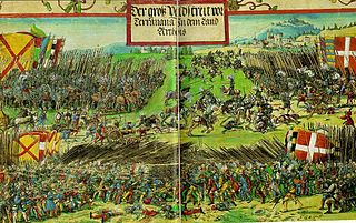
The Battle of the Spurs, or Battle of Guinegate, took place on 16 August 1513. It formed a part of the War of the League of Cambrai, during the ongoing Italian Wars. Henry VIII and Maximilian I were besieging the town of Thérouanne in Artois. Henry's camp was at Guinegate, now called Enguinegatte. A large body of French heavy cavalry under Jacques de La Palice was covering an attempt by light cavalry to bring supplies to the besieged garrison. English and Imperial troops surprised and routed this force. The battle was characterised by the precipitate flight and extensive pursuit of the French; the name of the battle derives from the French spurring their horses to effect their escape. During the pursuit a number of notable French leaders and knights were captured. After the fall of Thérouanne, Henry VIII besieged and took Tournai.

The Métropole Européenne de Lille (MEL) - "European Metropolis of Lille" is the métropole, an intercommunal structure, composed by a network of big cities whose major city is the city of Lille. It is located in the Nord department, in the Hauts-de-France region, northern France – bordering both the Flemish and Walloon regions of Belgium. It was created in January 2015, replacing the previous Communauté urbaine de Lille, and covers that part of the Lille metropolitan area that lies in France. Its population was 1,154,103 in 2014, of which 238,381 in Lille proper.

The Montagne Sainte-Geneviève is a hill overlooking the left Bank of the Seine in the 5th arrondissement of Paris. Atop the Montagne, are the Panthéon and the Bibliothèque Sainte-Geneviève, used by the students of the University of Paris. The side streets of the Montagne feature bars and restaurants, for example, in the Rue Mouffetard.

Jemmape[ʒɛ.map] was a department of the First French Empire in present-day Belgium. It was named after the Battle of Jemappes, fought between the French and the Austrians in 1792 near the village of Jemappes, near Mons. Jemappes was spelled Jemmape, Jemmapes or Jemmappes at the time. Its territory corresponded more or less with that of the Belgian province of Hainaut. Its capital was Mons.
The Tournaisian is in the ICS geologic timescale the lowest stage or oldest age of the Mississippian, the oldest subsystem of the Carboniferous. The Tournaisian age lasted from 358.9 Ma to 346.7 Ma. It is preceded by the Famennian and is followed by the Viséan.

The arrondissement of Châlons-en-Champagne is an arrondissement of France in the Marne department in the Grand Est region. Since the April 2017 reorganization of the arrondissements of Marne, it has 150 communes.
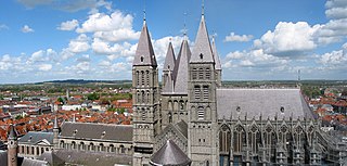
The Tournai Cathedral, or Cathedral of Our Lady , is a Roman Catholic church, see of the Diocese of Tournai in Tournai, Belgium. It has been classified both as a Wallonia's major heritage since 1936 and as a World Heritage Site since 2000.

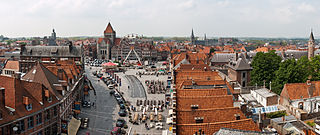
The belfry of Tournai, Belgium, is a freestanding bell tower of medieval origin, 72 metres in height with a 256-step stairway. This landmark building is one of a set of belfries of Belgium and France registered on the UNESCO World Heritage List.

The Battle of Tournay (1794) or Tournai was fought on 22 May 1794 as part of the Flanders Campaign in the Belgian province of Hainaut on the Schelde River between French forces under General Pichegru and Coalition forces under Prince Josias of Coburg, in which the Coalition forces were victorious.

The Musée des Beaux-Arts in Tournai, Belgium, is an art museum.

UCLouvain FUCaM Mons is a campus of the University of Louvain (UCLouvain) in Mons, Wallonia, Belgium. Until 2011, it was an independent institution known as the Catholic university of Mons. It is a catholic university funded by the French Community of Belgium for whom it holds the status of a free institution. Its official language is French.

The former French Catholic diocese of Noyon lay in the north-east of France, around Noyon. It was formed when Saint Medardus moved the seat of the bishopric at Vermandois to Noyon, in the sixth century. For four centuries it was united with the bishopric of Tournai. Then in the twelfth century it was again independent, and the bishop of Noyon became a pairie-comté of France.

The railway station of Tournai, in Belgium, is situated on line 94. The first train arrived there on 24 January 1842. A first neo-classical stone building dating from the 1840s was later dismantled and replaced to serve as the railway station of the town of Leuze-en-Hainaut. The current station building was designed by Henri Beyaert and erected between 1874-1879. The monumental building originally included a glass and iron construction covering the platforms and rails, and a "gare des marchandises" located in a separate building conceived in the form of a late-medieval Flemish cloth-hall. The buildings were severely damaged during World War II. The structure covering the platforms and rails was demolished and replaced by simple awnings covering the platforms.

The Roman Catholic Diocese of Tournai is a diocese of the Latin Rite of the Roman Catholic church in Belgium. The diocese was formed in 1146, upon the dissolution of the diocese of Noyon & Tournai, which had existed since the 7th century. It is now suffragan of the archdiocese of Mechelen-Brussels.

The Church of Saint-Étienne, Lille is a Roman Catholic church located on the rue de l'Hôpital Militaire in Lille, France. It has been classed as a monument historique since 1987 and is dedicated to Saint Stephen. It is one of the largest Jesuit churches in France.

The Siege of Antwerp took place after fighting in the Belgian Revolution ended. On 15 November 1832, the French Armée du Nord under Marshal Gérard began to lay the Dutch troops there under David Chassé under siege. The siege ended 23 December 1832. The French had agreed with the Belgian rebels that they would not participate in the battle.
Eurometropolis Lille–Kortrijk–Tournai is a binational metropolitan area in the European Union around the French city of Lille, and the Belgian cities Kortrijk and Tournai.

Mont-Saint-Aubert is a village in the Belgian province Hainaut and a sub-municipality of the city Tournai. The village lies at the north side of Tournai.