
Presidio is a city in Presidio County, Texas, United States. It stands on the Rio Grande, on the opposite side of the U.S.–Mexico border from Ojinaga, Chihuahua. The name originates from the Spanish and means "jail". The population was 4,167 at the 2000 census, and had increased to 4,426 as of the 2010 US census.

Borsigwerke is a Berlin U-Bahn station located on the U 6.

KPIR is a news talk radio station licensed to and serving the area around Granbury, Texas. The station transmits from a three tower array in the daytime and from two towers at night with 500 Watts.
The Presidio–Ojinaga International Bridge is an international bridge that crosses the Rio Grande between the cities of Presidio, Texas, and Ojinaga, Chihuahua, on the United States-Mexico border. It connects U.S. Route 67 to the north with Mexican Federal Highway 16 to the south. The bridge is also known as "Presidio Bridge" and "Puente Ojinaga". The Presidio–Ojinaga International Bridge is currently privately owned, and a toll fee is charged. The bridge was completed and opened in 1985 and is two lanes wide and 791 feet (241 m) long.

Kayk, formerly known as Melkon-kend and Mulki, is a village in the Aragatsotn Province of Armenia.
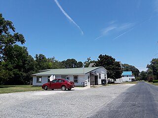
Craddockville is an unincorporated community in Accomack County, Virginia, United States.
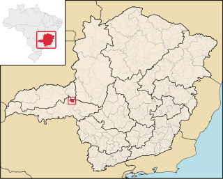
Pedrinópolis is a Brazilian municipality located in the west of the state of Minas Gerais. Its population as of 2007 was 3,448 people living in a total area of 357 km². The city belongs to the meso-region of Triângulo Mineiro and Alto Paranaíba and to the micro-region of Araxá. It became a municipality in 1962.

Poverty Ridge is an unincorporated community in Fulton County, Illinois, United States, about eleven miles northwest of Lewistown. Its elevation is 633 feet (202 m), and it is located at 40°27′43″N90°20′27″W. The community is named for a line of hills near Seville, which likewise is named Poverty Ridge.

Croft is an unincorporated community in El Dorado County, California. It is located 1.5 miles (2.4 km) south of Caldor, at an elevation of 4,518 feet.
Monte Castelo is a municipality in Santa Catarina in the South region of Brazil.

Gouna is a village and rural commune in Niger.
Tlahuapan (municipality) is a town and municipality in Puebla in south-eastern Mexico.
The Presidio–Ojinaga International Rail Bridge is an international bridge that crosses the Rio Grande between the cities of Presidio, Texas, and Ojinaga, Chihuahua, on the United States-Mexico border. The Presidio–Ojinaga International Rail Bridge is currently closed. It was damaged by fire on 29 February 2008, but there are plans to repair it. It is owned by the Mexican government and the state of Texas Department of Transportation. It was privately operated under a lease by Ferromex subsidiary Texas Pacifico Transportation.
Potereo de Llano is a rural community located in Ojinaga Municipality, Chihuahua, Mexico. It had a population of 120 inhabitants at the 2010 census, and is situated at an elevation of 1,040 meters above sea level.
Maijoma is a rural community located in Ojinaga Municipality, Chihuahua, Mexico. It had a population of 160 inhabitants at the 2010 census, and is situated at an elevation of 1,382 meters above sea level.
El Oasis is a rural community in Ojinaga Municipality, Chihuahua, Mexico. It had a population of 475 inhabitants at the 2010 census, and is situated at an elevation of 1,204 meters above sea level.

Collège de Rosement is a French public college in Montreal (Quebec), Canada. The school was founded in September 1954 by Father Gerard Cornellier. It is located at 6400 16th avenue, corner Beaubien Street in the borough of Rosemont–La Petite-Patrie.
Isom is an unincorporated community in Dickenson County, Virginia, in the United States.
Tims Mountain is a summit in Iron County in the U.S. state of Missouri. The summit has an elevation of 1,404 feet (428 m).


