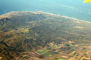
Point Arguello is a headland on the Gaviota Coast, in Santa Barbara County, California, near the city of Lompoc. The area was first used by the United States Navy in 1959 for the launch of military and sounding rockets. It was transferred to the United States Air Force in 1964, at which time it became part of Vandenberg Air Force Base.
Rancho Dos Pueblos was a 15,535-acre (62.87 km2) Mexican land grant in present day Santa Barbara County, California given in 1842 by Governor Juan Alvarado to Nicolas A. Den. The rancho stretched along the Pacific coast to the northwest of today's city of Santa Barbara, from Fairview Avenue in Goleta to the southeastern boundary of today's El Capitan State Beach. A 500-acre parcel was bought by Colin Powys Campbell in 1919. That parcel is now owned by University of California, Santa Barbara which purchased it from the Devereux Foundation in 2007, following the closure of the campus it had established there in 1945.
Rancho Santa Paula y Saticoy was a 17,773-acre (71.92 km2) Mexican land grant in the Santa Clara River Valley, in present-day Ventura County, California, and granted in 1843 by Governor Manuel Micheltorena to Manuel Jimeno Casarin. The rancho lands include the modern communities of Saticoy and Santa Paula along the Santa Clara River.

Rancho El Cajón was a 48,800-acre (197 km2) Mexican land grant in present day San Diego County, California given in 1845 by Governor Pio Pico to María Antonia Estudillo de Pedrorena. The name means "the box" in Spanish, and refers to the valley between hills. The grant encompassed present day El Cajon, Bostonia, Santee, Lakeside, Flinn Springs, and the eastern part of La Mesa. The grant contained the 28-acre (0.11 km2) Rancho Cañada de los Coches grant.
Rancho La Laguna was a 48,704-acre (197.10 km2) Mexican land grant in present-day Santa Barbara County, California given in 1845 by Governor Pio Pico to Octaviano Gutierrez. The name means "the Lake". The grant extended along the Santa Ynez Valley east of present-day Los Alamos.
Rancho Huasna was a 22,153-acre (89.65 km2) Mexican land grant in present-day San Luis Obispo County, California given in 1843 by Governor Manuel Micheltorena to Isaac J. Sparks. The grant extended along the Huasna River and the western slope of the Santa Lucia Range, east of present-day Arroyo Grande and encompassing Huasna.
Rancho Pismo was a 8,839-acre (35.77 km2) Mexican land grant in present day San Luis Obispo County, California, given in 1840 by acting governor Manuel Jimeno Casarin to José Ortega. The grant extended along the Pacific coast and encompassed present day Pismo Beach, Grover Beach, Shell Beach and parts of Arroyo Grande.
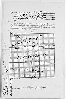
Rancho Lompoc was a 42,085-acre (170.31 km2) Mexican land grant in present-day Santa Barbara County, California given in 1837 by Governor Juan B. Alvarado to Joaquín Carrillo and José Antonio Carrillo. The grant extended from present-day Lompoc west to the Pacific coast.
Rancho Mission Vieja de la Purisma was a 4,414-acre (17.86 km2) Mexican land grant in present-day northern Santa Barbara County, California given in 1845 by Governor Pío Pico to Joaquín Carrillo and José Antonio Carrillo. The grant included the original site of Mission La Purísima Concepción, located north of present-day Lompoc.
Rancho Calleguas was a 9,998-acre (40.46 km2) Mexican land grant in present-day Ventura County, California given in 1837 by Governor Juan Alvarado to José Pedro Ruiz.
Rancho Ojai was a 17,717-acre (71.70 km2) Mexican land grant in present-day Ventura County, California given in 1837 by Governor Juan Alvarado to Fernando Tico. Rancho Ojai is located on the east side of the upper Ventura River, across from the Rancho Santa Ana grant made in the same year. The grant encompassed present-day city of Ojai, at the foot of the Topatopa Mountains.
Rancho La Goleta was a 4,426-acre (17.91 km2) Mexican land grant in present-day Santa Barbara County, California given in 1846 by Governor Pío Pico to Daniel A. Hill. The grant extended along the Pacific coast from today’s Fairview Avenue in present-day Goleta, east to Hope Ranch. The grant was adjacent to Rancho Dos Pueblos granted to his son-in-law Nicolas A. Den in 1842.

Rancho Punta del Año Nuevo was a 17,753-acre (71.84 km2) Mexican land grant in present day San Mateo County, California given in 1842 by Governor Juan B. Alvarado to Simeon Castro. At the time, the grant was in Santa Cruz County; an 1868 boundary adjustment gave the land to San Mateo County. The grant extended along the Pacific coast from Rancho Butano and Arroyo de los Frijoles on the north, past Pigeon Point, Franklin Point to Point Año Nuevo on the south.
Rancho Juristac was a 4,540-acre (18.4 km2) Mexican land grant in present-day Santa Clara County, California given in 1835 by Governor José Castro to Antonio and Faustino German. The rancho was once noted for its liquid petroleum deposits. Rancho Juristac, five miles south of Gilroy, is the southernmost rancho in Santa Clara County, and encompasses Sargent.
Rancho Santa Rosa was a 15,526-acre (62.83 km2) Mexican land grant in present day Santa Barbara County, California one and half square leagues given in 1839 by Governor Pro-tem Manuel Jimeno, and two additional square leagues given in 1845 by Governor Pío Pico to Francisco Cota. The grant in the Santa Ynez Valley extended along both banks of the Santa Ynez River at Santa Rosa Creek, west of present day Buellton.
Rancho Bolsa de Chamisal was a 14,335-acre (58.01 km2) Mexican land grant in present-day San Luis Obispo County, California given in 1837 by Governor Juan B. Alvarado to Francisco Quijada. The grant extended along the Pacific coast, just south of present-day Oceano, and was bordered on the north by Rancho Pismo and the south by Rancho Guadalupe.
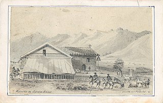
Rancho Santa Ana was a 21,522-acre (87.10 km2) Mexican land grant in present day Ventura County, California given in 1837 by Governor Juan Alvarado to Crisogono Ayala and Cosme Vanegas. Rancho Santa Ana was located inland in the Ventura River Valley on the west side of the Ventura River across from Rancho Ojai which was granted in the same year. Rancho Santa Ana encompassed present day Lake Casitas and Oak View.

Las Cruces is a former settlement and an archaic placename in Santa Barbara County, California. It lies at the split between California State Route 1, which travels north to Lompoc, and U.S. Route 101, which travels north to Buellton. The two routes coincide on the highway to the south through the Gaviota Gorge to the Gaviota Coast. The community lies within area code 805.

The history of Santa Maria, California, starts with the native Chumash people, who lived there for several thousand years before the Spanish Empire colonized the region in the 18th century. Later, it was a part of the Mexican Empire, California Republic, and finally, the United States. The city was incorporated in 1905, when it had a population of 3,000. As of the 2020 U.S. census, the population was 109,707.

The Pico family is a prominent Californio family of Southern California. Members of the family held extensive rancho grants and numerous important positions, including Governor of Alta California, signer of the Constitution of California, and California State Senator, among numerous others. Numerous locations are named after the family across California.