
San Luis is a province of Argentina located near the geographical center of the country. Neighboring provinces are, from the north clockwise, La Rioja, Córdoba, La Pampa, Mendoza and San Juan.
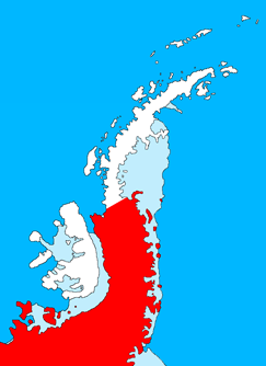
Palmer Land is the portion of the Antarctic Peninsula, Antarctica that lies south of a line joining Cape Jeremy and Cape Agassiz. This application of Palmer Land is consistent with the 1964 agreement between the Advisory Committee on Antarctic Names and the UK Antarctic Place-Names Committee, in which the name Antarctic Peninsula was approved for the major peninsula of Antarctica, and the names Graham Land and Palmer Land for the northern and southern portions, respectively. The line dividing them is roughly 69° S.
San José de Bocay is a town and a municipality in the Jinotega department, Nicaragua.

Tarandacuao is a Mexican city located in the lowlands of the state of Guanajuato. The municipality has an area of 117.39 square kilometres, and is bordered to the north and east by Jerécuaro, to the south by the state of Michoacán, and to the west by Acámbaro. The municipality had 11,583 inhabitants according to the 2005 census. Outlying communities found in Tarandacuao include La Purísima, San Juan De Dios, San José de Hidalgo, San Antonio, El Tocuz, San felipe and La Virgen.
Pobladura de Valderaduey is a municipality located in the province of Zamora, Castile and León, Spain. According to the 2004 census (INE), the municipality had a population of 66 inhabitants.

Boecillo is a municipality located in the province of Valladolid, Castile and León, Spain. As of 2018, the population is 4,154.

Chimbas is a department of the province of San Juan, Argentina. It is located on the south bank of the San Juan River, and is part of greater San Juan. The department is thoroughly urbanized and industrial.

Estadio Municipal Lucio Fariña Fernández is a multi-use stadium in Quillota, Chile. It is currently used mostly for football matches, and is the home stadium of San Luis which currently plays at the second tier of the Chilean league system. The stadium holds 7,680 spectators. The stadium was opened on September 15, 2010 in a San Luis against Universidad de Concepcion, match which ended in a final 1-0 for the home team.
Leandro N. Alem is a village and municipality in San Luis Province in central Argentina.
Nogolí is a village and municipality in San Luis Province in central Argentina.
Río Juan Gómez is a village and municipality in San Luis Province in central Argentina.
San Francisco del Monte de Oro is a village and municipality in San Luis Province in central Argentina.
Villa General Roca is a village and municipality in San Luis Province in central Argentina.
Villa de Praga is a village and municipality in San Luis Province in central Argentina.

Barnes Glacier is a glacier on the west side of Hemimont Plateau flowing west into Blind Bay on the west coast of Graham Land. It was named by the UK Antarctic Place-Names Committee in 1958 for Howard T. Barnes, Canadian physicist and pioneer of ice engineering.

Cardell Glacier is a glacier draining the north slopes of Roygos Ridge and flowing northwestwards into Darbel Bay between Shanty Point and Panther Cliff, on the west coast of Graham Land, Antarctica.
Davis Valley is an ice-free valley just east of Floridas Ridge in north-east Dufek Massif, in the Pensacola Mountains, Antarctica.
