
The Arctic Archipelago, also known as the Canadian Arctic Archipelago, is an archipelago lying to the north of the Canadian continental mainland, excluding Greenland and Iceland.

USS Card was an American Bogue-class escort carrier that saw service in World War II. She was named for Card Sound, a continuation of Biscayne Bay, south of Miami, Florida. She was the flagship of Task Group 21.14 a hunter-killer group formed to destroy German submarines in the North Atlantic.

The Priestley Glacier is a major valley glacier, about 60 nautical miles long, originating at the edge of the Polar Plateau of Victoria Land, Antarctica. The glacier drains southeast between the Deep Freeze Range and Eisenhower Range to enter the northern end of the Nansen Ice Sheet. It was first explored by the Northern Party of the British Antarctic Expedition, 1910–13, and named for Raymond Priestley, a geologist with the Northern Party.

Yamparáez is a province in the Bolivian department of Chuquisaca. It is divided in two sections: first section with head in the town of Tarabuco, and the second section with its head in Yamparáez.

The Prince Charles Mountains are a major group of mountains in Mac. Robertson Land in Antarctica, including the Athos Range, the Porthos Range, and the Aramis Range. The highest peak is Mount Menzies, with a height of 3,228 m (10,591 ft). Other prominent peaks are Mount Izabelle and Mount Stinear. These mountains, together with other scattered peaks, form an arc about 420 km (260 mi) long, extending from the vicinity of Mount Starlight in the north to Goodspeed Nunataks in the south.
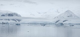
Leonardo Glacier is a glacier flowing into Wilhelmina Bay between Sadler Point and Café Point, on the west coast of Graham Land, Antarctica. It was charted by the Belgian Antarctic Expedition under Gerlache, 1897–99, and was named by the UK Antarctic Place-Names Committee in 1960 for Leonardo da Vinci, artist, musician, architect and the first aeronautical scientist.
Escobar de Campos is a municipality located in the province of León, Castile and León, Spain. According to the 2010 census (INE), the municipality has a population of 56 inhabitants.

Castroverde de Campos is a municipality located in the province of Zamora, Castile and León, Spain. According to the 2021 census (INE), the municipality has a population of 272 inhabitants.
Fresno de Sayago is a municipality located in the province of Zamora, Castile and León, Spain. According to the 2009 census (INE), the municipality has a population of 242 inhabitants.

Liv Glacier is a steep valley glacier, 40 nautical miles long, emerging from the Antarctic Plateau just southeast of Barnum Peak and draining north through the Queen Maud Mountains to enter Ross Ice Shelf between Mayer Crags and Duncan Mountains. It was discovered in 1911 by Roald Amundsen, who named it for the daughter of Fridtjof Nansen.
Fitampito is a rural municipality in Madagascar. It belongs to the district of Ikalamavony, which is a part of Haute Matsiatra Region. The population of the commune was estimated to be approximately 9,546 in 2018.
Simão Pereira is a municipality in the state of Minas Gerais in the Southeast region of Brazil.

Birley Glacier is a glacier, at least 10 nautical miles (19 km) long, flowing west into the eastern extremity of Barilari Bay north of Vardun Point, on the west coast of Graham Land. First seen and roughly surveyed in 1909 by the French Antarctic Expedition under Jean-Baptiste Charcot, it was re-surveyed in 1935–36 by the British Graham Land Expedition (BGLE) under John Rymill, and later named for Kenneth P. Birley, who contributed toward the cost of the BGLE, 1934–37.
The Gothic Mountains is a group of mountains, 20 nautical miles long, in the Queen Maud Mountains of Antarctica, located west of Watson Escarpment and bounded by Scott Glacier, Albanus Glacier, and Griffith Glacier.

Breitfuss Glacier is a glacier 10 nautical miles (19 km) long, which flows southeast from Avery Plateau into Mill Inlet to the west of Cape Chavanne, on the east coast of Graham Land. It was charted by the Falkland Islands Dependencies Survey (FIDS) and photographed from the air by the Ronne Antarctic Research Expedition in 1947. It was named by the FIDS for Leonid Breitfuss, a German polar explorer, historian, and author of many polar bibliographies.
Cayley Glacier is a glacier flowing northwest into the south side of Brialmont Cove, on the west coast of Graham Land.
Wallend Glacier is a deeply entrenched glacier which drains eastward from Forbidden Plateau to join Green Glacier in northern Graham Land. Surveyed by Falkland Islands Dependencies Survey (FIDS) in 1955. So named by United Kingdom Antarctic Place-Names Committee (UK-APC) because the glacier is walled in on three sides by the escarpment of Forbidden Plateau.
Green Glacier is a glacier on the east side of Graham Land, Antarctica, 15 nautical miles (28 km) long and 4 nautical miles (7 km) wide, flowing from the plateau northeast between Dugerjav Peak and Rugate Ridge, and then east into Vaughan Inlet next north of Pirne Peak and south of the terminus of Hektoria Glacier.

Manyinga District is a district of North-Western Province, Zambia. It was separated from Kabompo District in 2012.