
The geography of France consists of a terrain that is mostly flat plains or gently rolling hills in the north and the west and mountainous in the south and the east. Metropolitan France has a total size of 551,695 km2 (213,011 sq mi). It is the third-largest country in Europe by area and the largest in Western Europe.

The Arctic Archipelago, also known as the Canadian Arctic Archipelago, is an archipelago lying to the north of the Canadian continental mainland, excluding Greenland and Iceland.

Booth Island is a Y-shaped island, 5 nautical miles long and rising to 980 metres (3,220 ft) in the northeast part of the Wilhelm Archipelago, Antarctica.
The Reedy Glacier is a major glacier in Antarctica, over 100 nautical miles long and 6 to 12 nautical miles wide, descending from the polar plateau to the Ross Ice Shelf between the Michigan Plateau and Wisconsin Range in the Transantarctic Mountains. It marks the limits of the Queen Maud Mountains on the west and the Horlick Mountains on the east.

Shackleton Glacier is a major Antarctic glacier, over 60 nautical miles long and from 5 to 10 nautical miles wide, descending from the Antarctic Plateau from the vicinity of Roberts Massif and flowing north through the Queen Maud Mountains to enter the Ross Ice Shelf between Mount Speed and Waldron Spurs. Discovered by the United States Antarctic Service (USAS) (1939–41) and named by the Advisory Committee on Antarctic Names (US-ACAN) for Sir Ernest Shackleton, British Antarctic explorer.
The Victoria Cross Ranges are a set of mountain ranges in the Canadian Rockies, located to the northwest of Jasper. Of the 19 peaks contained within this range, five are named after Canadian recipients of the Victoria Cross. The area of the ranges is 678 square kilometres (262 sq mi).

The Prince Charles Mountains are a major group of mountains in Mac. Robertson Land in Antarctica, including the Athos Range, the Porthos Range, and the Aramis Range. The highest peak is Mount Menzies, with a height of 3,228 m (10,591 ft). Other prominent peaks are Mount Izabelle and Mount Stinear. These mountains, together with other scattered peaks, form an arc about 420 km (260 mi) long, extending from the vicinity of Mount Starlight in the north to Goodspeed Nunataks in the south.
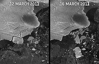
Sulzberger Bay is a bay indenting the front of the Sulzberger Ice Shelf between Fisher Island and Vollmer Island, along the coast of Marie Byrd Land, Antarctica.

Riello is a municipality located in the province of León, Castile and León, Spain. According to the 2004 census (INE), the municipality has a population of 864 inhabitants.

Bustillo de Chaves is a municipality located in the province of Valladolid, Castile and León, Spain. According to the 2004 census (INE), the municipality has a population of 102 inhabitants, and in 2012 it had 79 residents.

Flandres Bay is a large bay lying between Cape Renard and Cape Willems, along the west coast of Graham Land, Antarctica.
The Findlay Group is a group of islands in the Arctic Archipelago in Qikiqtaaluk Region, Nunavut. This Arctic Ocean group consists of Lougheed Island,A Stupart Island,B Edmund Walker Island,C Grosvenor IslandD and Patterson Island.E
Ipumirim is a municipality in the state of Santa Catarina in the South region of Brazil.

Limoeiro do Norte is a municipality in the state of Ceará in the Northeast region of Brazil.
Río Grande is a village and municipality in San Luis Province in central Argentina.
The Anderson Hills are an irregular group of hills, ridges and peaks between Mackin Table and the Thomas Hills in the Patuxent Range, Pensacola Mountains, Antarctica.

Bills Gulch is a glacier on the southeast side of Hemimont Plateau, the northern of two glaciers flowing east from the plateau upland into the head of Trail Inlet, on the east coast of Graham Land. This glacier was used by the sledge party under Paul H. Knowles which traversed the Antarctic Peninsula from the East Base of the United States Antarctic Service (USAS) on its way to Hilton Inlet in 1940. It was named by USAS for a lead dog that died at this point. The unlikely name has been approved because of its wide use on maps and in reports.
Hess Glacier is a glacier 5 nautical miles long, flowing east-northeast between steep rock walls to its terminus 10 nautical miles southwest of Monnier Point, on the east coast of Graham Land, Antarctica. It was charted in 1947 by the Falkland Islands Dependencies Survey, who named it for Hans Hess, a German glaciologist.

Sarnoff Mountains is a range of mountains, 251 nautical miles long and 4 to 8 nautical miles wide separating the west-flowing Boyd Glacier and Arthur Glacier in the Ford Ranges of Marie Byrd Land, Antarctica.
