La Serra d'Almos

Last updated
La Serra d'Almos
Village
Escudo de la Serra d'Almos.svg
Seal
Spain location map.svg
Red pog.svg
La Serra d'Almos
Location in Spain
Coordinates: 41°4′47.30″N0°44′39″E / 41.0798056°N 0.74417°E / 41.0798056; 0.74417
Country Spain
Autonomous community Catalonia
Province Tarragona
Comarca Ribera d'Ebre
Municipality Tivissa
Area
  Total 100 km2 (40 sq mi)
Elevation 229 m (751 ft)
Population (2009)
  Total 273
  Density 2.7/km2 (7.1/sq mi)
Time zone CET (UTC+1)
  Summer (DST) CEST (UTC+2)

La Serra d'Almos is a village located within the municipal term of Tivissa, in the Ribera d'Ebre comarca, Catalonia, Spain.

Tivissa Municipality in Catalonia, Spain

Tivissa is a municipality in the comarca of Ribera d'Ebre, Catalonia, Spain. It is located below the La Llena massif. As well as the village of Tivissa itself, the municipality also includes the village of La Serra d'Almos, at the feet of the Montalt mountains, and the hamlets of Darmós and Llaberia.

Ribera dEbre Comarca in Catalonia, Spain

Ribera d'Ebre is a comarca (county) in Catalonia, Spain. The name in Catalan refers to its location on the banks of the river Ebre, usually referred to in English by its Spanish name Ebro.

A comarca is a traditional region or local administrative division found in Portugal, Spain and some of their former colonies: Panama, Nicaragua, and Brazil. The term is derived from the term marca, meaning a "march, mark", plus the prefix co-, meaning "together, jointly".

Contents

History

Administratively La Serra d'Almos was formerly a municipality in its own right since 1787. In 1940, one year after the Spanish Civil War, the village was merged with the Tivissa municipality. Since 2009 it has become a Decentralized Municipal Entity (EMD), though still depending from Tivissa, located about 7 km away.

Spanish Civil War War between the Republicans and the Nationalists in Spain from 1936 to 1939

The Spanish Civil War took place from 1936 to 1939. Republicans loyal to the left-leaning Second Spanish Republic, in alliance with the Anarchists and Communists, fought against the Nationalists, an alliance of Falangists, Monarchists, and Catholics, led by General Francisco Franco. Due to the international political climate at the time, the war had many facets, and different views saw it as class struggle, a war of religion, a struggle between dictatorship and republican democracy, between revolution and counterrevolution, between fascism and communism. The Nationalists won the war in early 1939 and ruled Spain until Franco's death in November 1975.

Geography

La Serra d'Almos has a church dedicated to Sant Domingo. The village is located in picturesque surroundings, in view of the Valley of the Ebro River at the feet of the Serra de Montalt, a subrange of the Serra de Llaberia, surrounded by vineyards and olive trees. Nowadays it is a favoured agritourism destination.

Saint Dominic founder of the Dominican Order

Saint Dominic, also known as Dominic of Osma and Dominic of Caleruega, often called Dominic de Guzmán and Domingo Félix de Guzmán, was a Castilian priest and founder of the Dominican Order. Dominic is the patron saint of astronomers.

Serra de Llaberia mountain in Spain

Serra de Llaberia is a mountain chain in Catalonia, Spain located between the Prades and the Tivissa-Vandellòs Mountains.

Vineyard Plantation of grape-bearing vines

A vineyard is a plantation of grape-bearing vines, grown mainly for winemaking, but also raisins, table grapes and non-alcoholic grape juice. The science, practice and study of vineyard production is known as viticulture.

The wine produced in La Serra d'Almos is marketed under the Montsant DO denomination. Also local olives yield high-quality oil that has been awarded Protected Designation of Origin (PDO). This oil is marketed as DO Siurana. [1]

Montsant DO

Montsant is a Spanish Denominación de Origen, DO for wine located in the province of Tarragona and covers 12 municipalities. It was previously known as the Falset subzone of Tarragona (DO), and was created as a separate DO in the early 2000s. Regional approval came in 2001, and from 2002 wines were sold as Montsant rather than Tarragona. Montsant takes its name from the Montsant mountains in the area.

Olive oil fat obtained by pressing olives

Olive oil is a liquid fat obtained from olives, a traditional tree crop of the Mediterranean Basin. The oil is produced by pressing whole olives. It is commonly used in cooking, whether for frying or as a salad dressing. It is also used in cosmetics, pharmaceuticals, and soaps, and as a fuel for traditional oil lamps, and has additional uses in some religions. There is limited evidence of its possible health benefits. The olive is one of three core food plants in Mediterranean cuisine; the other two are wheat and grapes.

View of La Serra d'Almos Serra-d'almos62.JPG
View of La Serra d'Almos
Main street in La Serra d'Almos with Sant Domingo church Serra-d'almos3.JPG
Main street in La Serra d'Almos with Sant Domingo church

Related Research Articles

Priorat Comarca in Catalonia, Spain

Priorat is a comarca (county) in Catalonia, Spain. The central part of the comarca, "Priorat històric," produces the highly-regarded wines that are certified under the DOQ Priorat. Wines from elsewhere in the comarca are certified as DO Montsant although this region also has a small segment of the neighboring comarca, Ribera d'Ebre as well.

Baix Camp Comarca in Catalonia, Spain

Baix Camp is a comarca of Catalonia. It is one of the three comarques into which Camp de Tarragona was divided in the comarcal division of 1936.

Garcia, Tarragona Municipality in Catalonia, Spain

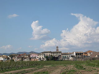
Garcia is a Spanish municipality in the Catalan comarca of Ribera d'Ebre, whose territory extends over both sides of the Ebre river.

Ascó Municipality in Catalonia, Spain

Ascó is a large village in the comarca of Ribera d'Ebre, Catalonia, Spain, on the right bank of the Ebre river at the feet of the Serra de la Fatarella range. The village of Ascó is known for its nuclear power station, and for excellent fishing in the river.

Móra la Nova Municipality in Catalonia, Spain

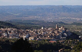
Móra la Nova is a municipality in the comarca, or district, of the Ribera d'Ebre in Catalonia, Spain. It is situated on the left bank of the Ebre river, facing the district capital Móra d'Ebre. It is served by a RENFE railway station on the line between Tarragona and Zaragoza and by the N-420 road to Gandesa and Reus.

Rasquera Municipality in Catalonia, Spain

Rasquera is a municipality in the comarca of Ribera d'Ebre in the province of Tarragona in Catalonia, Spain. It is located at the feet of the Serra de Cardó close to Highway C-12.

La Fatarella Municipality in Catalonia, Spain

La Fatarella is a municipality in northern Terra Alta, within the region of Ribera d'Ebre in Spain.

Catalan Pre-Coastal Range system of mountain ranges running parallel to the Mediterranean Sea coast in Catalonia

The Catalan Pre-Coastal Range is a system of mountain ranges running parallel to the Mediterranean Sea coast in Catalonia. It is part of the Catalan Mediterranean System. Its main axis runs between the Catalan Transversal Range and the Serra de l'Espina, which connects with the Ports de Tortosa-Beseit, part of the Iberian System. The highest point is 1.706,7 m at the Montseny Massif.

Bajo Aragón-Caspe Comarca in Aragon, Spain

Bajo Aragón-Caspe or Baix Aragó-Casp is a comarca in eastern Aragon, bordering the Spanish Autonomous Community of Catalonia.

Serra dEspadà mountain in the Land of Valencia

Serra d'Espadà is a 51 km (32 mi) long mountain range in the Alt Palància, Alt Millars and Plana Baixa comarcas, in the Province of Castellón, Valencian Community, Spain. Its highest point is La Ràpita.

Serra Calderona mountain in Spain

Serra Calderona, often referred to as La Calderona is a 49 km (30 mi) long mountain range in the Camp de Túria, Horta Nord and Alt Palància comarcas of the Valencian Community, between the provinces of Castelló and Valencia Spain.

La Palma dEbre Municipality in Catalonia, Spain

La Palma d'Ebre is a municipality in the comarca of Ribera d'Ebre, Tarragona Province, Catalonia, Spain. Despite its name, it is not located close to the Ebre river. There is a reservoir less than 1 km north of the town.

Montalt mountain in Spain

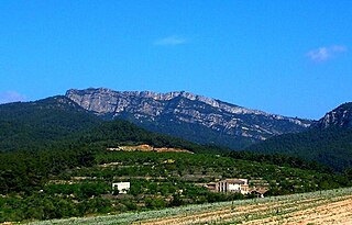
Montalt is a mountain that is part of the Serra de Montalt, Serra de Llaberia, Catalonia, Spain. It has an elevation of 749 metres above sea level.

Serra de la Vall de la Torre

Serra de la Vall de la Torre, also known as Serra de la Vall, is a mountain range located at the southern end of the Catalan Pre-Coastal Range, Catalonia, Spain. The ridge's highest point is 450.8 m. This mountain range lies within the Benissanet and Corbera d'Ebre municipal term. It is a smaller and lower northern prolongation of the Serra de Cavalls.

Mount Picossa mountain in Spain

Mount Picossa is a mountain in Catalonia, Spain. It is located within the Móra d'Ebre municipal limits, Ribera d'Ebre.

References