The Madagascar subhumid forests are a tropical moist broadleaf forest ecoregion that covers most of the Central Highlands of the island of Madagascar. They are included in the WWF's Global 200 list of outstanding ecoregions. Most of the original habitats have been lost due to human pressure.

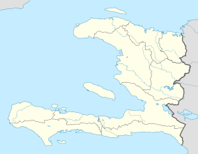
Pic Macaya National Park is one of two largest national parks of the Republic of Haiti. It is located in the country's southern peninsula, within the Massif de la Hotte. Featuring the country's last stand of virgin cloud forest, it encompasses more than 8,000 hectares. Elevations in the rugged park reach a maximum height of 2,347 meters above sea level at Pic Macaya, the second highest point in Haiti behind Pic la Selle. A majority of the park is composed of two tall peaks: Pic Macaya and Pic Formon.

Cutervo National Park , established in 1961, is the oldest protected area in Peru. It is located in the northern Peruvian Andes, in the region of Cajamarca. The park was extended to 8,214 hectares (31.71 sq mi) and protects areas of Andean montane forests and paramo for headwater conservation. Moreover, those areas are the habitat of animal species like the spectacled bear, the mountain tapir, and the oilbird; and plant species like the Andean wax palms.

The Chin Hills-Arakan Yoma montane forests is a tropical and subtropical moist broadleaf forest ecoregion in western Myanmar (Burma). Surrounded at lower elevations by moist tropical forests, this ecoregion is home a diverse range of subtropical and temperate species, including many species characteristic of the Himalayas, as well as many endemic species.

The Taiwan subtropical evergreen forests is an ecoregion that covers most of the island of Taiwan, with the exception of the southern tip of the island, which constitutes the South Taiwan monsoon rain forests ecoregion. The island's concentrated steep mountains host a range of forest types, from subtropical forests in the lowlands to temperate and alpine or montane forests.

The Talamancan montane forests ecoregion, in the tropical moist broadleaf forest biome, are in montane Costa Rica and western Panama in Central America.

Iztaccíhuatl–Popocatépetl National Park, also known as Izta-Popo Zoquiapan National Park, is a national park in Mexico on the border of the states of México, Puebla, and Morelos. The park protects 39,819.08 hectares, surrounding Mexico's second- and third-highest peaks, the Popocatépetl and Iztaccíhuatl volcanoes as well as the area of the Hacienda de Zoquiapán, and its annexed areas (anexas) of Zoquiapan, Ixtlahuacán, and the Frío de Juárez River.
The La Selle dusky frog or Mable's robber frog is a species of frog in the family Eleutherodactylidae. It is endemic to Hispaniola and known from the Massif de la Selle, both in the Dominican Republic and in Haiti. Its natural habitats are mesic pine and broadleaf forests. It is threatened by habitat loss. It is moderately common in suitable habitat, but threatened by habitat loss caused by logging and agriculture. It is known from both La Visite National Park (Haiti) and Sierra de Bahoruco National Park, but habitat degradation is occurring in these areas too.

The Greater Antillean elaenia is a species of bird in subfamily Elaeniinae of family Tyrannidae, the tyrant flycatchers. It is found in the Dominican Republic, Haiti, and Jamaica.

The La Selle thrush is a species of bird in the family Turdidae endemic to the Caribbean island of Hispaniola. A skulker of broadleaf and pine forests around 1300m, it is limited to a small and declining population in the inland Dominican Republic, as well as a relict population in Haiti.

The Hispaniolan trogon, also known as cacos is a species of bird in the family Trogonidae. It is endemic to Hispaniola in the Caribbean. It is one of the only two trogon species found in the Caribbean. It is the national bird of Haiti.
Nectandra caudatoacuminata is a species of plant in the family Lauraceae. It is a tree endemic to the Massif de la Hotte in southwestern Haiti.

The Southern Andean Yungas is a tropical and subtropical moist broadleaf forest ecoregion in the Yungas of southwestern Bolivia and northwestern Argentina.

Montane ecosystems are found on the slopes of mountains. The alpine climate in these regions strongly affects the ecosystem because temperatures fall as elevation increases, causing the ecosystem to stratify. This stratification is a crucial factor in shaping plant community, biodiversity, metabolic processes and ecosystem dynamics for montane ecosystems. Dense montane forests are common at moderate elevations, due to moderate temperatures and high rainfall. At higher elevations, the climate is harsher, with lower temperatures and higher winds, preventing the growth of trees and causing the plant community to transition to montane grasslands and shrublands or alpine tundra. Due to the unique climate conditions of montane ecosystems, they contain increased numbers of endemic species. Montane ecosystems also exhibit variation in ecosystem services, which include carbon storage and water supply.

The Guinean montane forests are a tropical moist broadleaf forest ecoregion of West Africa.

The wildlife of Haiti is important to the country because of its biodiversity. According to the World Conservation Monitoring Centre, Haiti is considered to be "one of the most biologically significant countries of the West Indies". With an estimated 5,600 plant species on the island of Hispaniola, some of which only occur in Haiti, 36% are considered as endemic to the island. A mountainous area country, it is situated in the western three-eighths of Hispaniola and shares a border with the Dominican Republic. There are nine life zones, from low desert to high cloud forests, as well as four mountain ranges, and hundreds of rivers and streams and the coral reefs in the seas that surround the islands. Issues of environmental damage, expanding population, deforesting and erosion are of concern; less than 2% of the original forest remains on account of deforestation. This degradation is traced from the 17th century to 19th century starting with the French colonization of the Haiti and population explosion during the 20th century and for the purpose of forestry and sugar-related industries, degraded the forests. and the environment.

The Central American montane forests are an ecoregion of the tropical and subtropical moist broadleaf forests biome, as defined by the World Wildlife Fund, located in mountains of Central America.
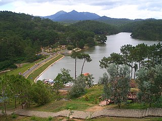
The Southern Annamites montane rain forests ecoregion covers a region of high biodiversity in the central and southern mountains of the Annamite Range in Vietnam. Terrain ranges from wet lowland forest to evergreen hardwood and conifer montane rain forest. There is a short dry season centered on January–February, but fog and dew are common throughout the year and support a lush forest character.

Pico de Tancítaro, also known as Volcán Tancítaro, is a volcanic mountain in Mexico. It is located in Tancítaro municipality in Michoacán state. It is the highest peak in Michoacán.
Frodinia tremula is a species of plant in the family Araliaceae. It is a scrambling tree endemic to the island of Hispaniola.