Related Research Articles

Hoogvliet is a borough of Rotterdam, Netherlands. As of 1 January 2023, it had 35,885 inhabitants. There is also a national chain of Dutch supermarkets with the same name.

Ottoland is a village in the Dutch province of South Holland. It is a part of the municipality of Molenlanden, and lies about 15 km northwest of Gorinchem.
Ackersdijk en Vrouwenregt is a former municipality in the Dutch province of South Holland, located about halfway between Delft and Schiedam. It existed from 1817 to 1855, when it was joined to the municipality of Vrijenban. The area is now part of the municipalities of Midden-Delfland, Delft, and Pijnacker-Nootdorp.
Duiveland is the name of a former island and a former municipality in the Dutch province of Zeeland.

Dubbeldam is a former village in the Dutch province of South Holland. It was located to the east of the city of Dordrecht. It is now a part of that city.
Hofwegen is a hamlet in Molenlanden, which is a municipality in the Dutch province of South Holland. It is located on the south bank of the small river Graafstroom. It is now considered to be part of the village of Bleskensgraaf, which lies on the opposite bank.
IJsselmonde is a former village in the Dutch province of South Holland. It was located to the east of the city of Rotterdam. The village derives its name from the river Hollandsche IJssel, which flows into the Nieuwe Maas opposite the village. The village gives its name to the large island it's on, IJsselmonde.
Kethel en Spaland is a former municipality in the Dutch province of South Holland. It was located to the north of the city of Schiedam, and covered the village of Kethel and the hamlet Kandelaar.
Langebakkersoord is a former municipality in the Dutch province of South Holland. It was located northwest of Hoogvliet, on the confluence of the Oude Maas and Nieuwe Maas rivers.
Meerdervoort is a former municipality in the Dutch province of South Holland. It was southwest of the town of Zwijndrecht.
Nieuwland, Kortland, en 's-Graveland is a former municipality in the Dutch province of South Holland. It was located on three sides of the city of Schiedam. The municipality existed between 1817 and 1855.
Oost-Barendrecht is a former municipality in the Dutch province of South Holland. It covered the eastern part of the current municipality of Barendrecht.
West-Barendrecht is a former municipality in the Dutch province of South Holland. It covered the western part of the current municipality of Barendrecht, including the village of Carnisse.
Oude en Nieuwe Struiten is a former municipality in the Dutch province of South Holland. It consisted of a small polder east of Hellevoetsluis, and is now covered by the suburbs Wittenshoeck and De Struyten of that city.

Overschie is a neighborhood of Rotterdam, Netherlands, formerly a separate village with its own municipality.

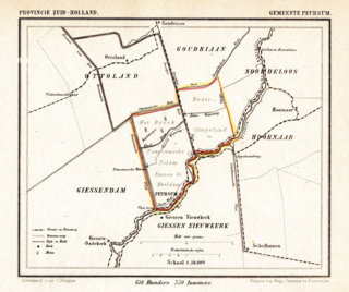
Peursum is a former village and municipality in the Dutch province of South Holland, located on the north bank of the river Giessen. It was a separate municipality between 1817 and 1956, when it became part of Giessenburg. In 1857, Peursum was enlarged with the former municipality of Nederslingeland.

Rijsoord is a village in the Dutch province of South Holland. It is located about 10 km southeast of the city of Rotterdam, in the municipality of Ridderkerk.

Schiebroek is a former village in the province of South Holland, Netherlands. It is now a neighbourhood of Rotterdam, and part of the borough of Hillegersberg-Schiebroek.

Sint Maartensregt is a former municipality in the Dutch province of South Holland. It consisted of two former manors: "Sint Maartensregt" and "Dorp-Ambacht".

Vlaardinger-Ambacht is a former municipality in the Dutch province of South Holland. It covered the countryside around the city of Vlaardingen.
References
- ↑ Ad van der Meer and Onno Boonstra, "Repertorium van Nederlandse gemeenten", KNAW, 2006. "KNAW > Publicaties > Detailpagina". Archived from the original on 2007-02-20. Retrieved 2009-12-03.
51°53′27″N4°50′48″E / 51.890716°N 4.846687°E