
Blackburn is a suburb of Melbourne, Victoria, Australia, 16 kilometres (9.9 mi) east of Melbourne's Central Business District, located within the City of Whitehorse local government area. Blackburn recorded a population of 14,478 at the 2021 census.
Blackburn South is a suburb of Melbourne, Victoria, Australia, 16 km east of Melbourne's Central Business District, located within the City of Whitehorse local government area. Blackburn South recorded a population of 10,939 at the 2021 census.
Blackburn North is a suburb of Melbourne, Victoria, Australia, 17 km east of Melbourne's Central Business District, located within the City of Whitehorse local government area. Blackburn North recorded a population of 7,627 at the 2021 census.

Box Hill North is a suburb of Melbourne, Victoria, Australia, 14 km east from Melbourne's Central Business District, located within the City of Whitehorse local government area. Box Hill North recorded a population of 12,337 at the 2021 census.

Box Hill South is a suburb of Melbourne, Victoria, Australia, 14 km east of Melbourne's Central Business District, located within the City of Whitehorse local government area. Box Hill South recorded a population of 8,491 at the 2021 census.

Burwood is a suburb of Melbourne, Victoria, Australia, 14 kilometres east of Melbourne's Central Business District, located within the Cities of Monash and Whitehorse local government areas. Burwood recorded a population of 15,147 at the 2021 census.

Burwood East is a suburb of Melbourne, Victoria, Australia, located 17 km (11 mi) east of Melbourne's Central Business District, located within the City of Whitehorse local government area. Burwood East recorded a population of 10,675 at the 2021 census.
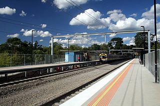
Laburnum railway station is located on the Lilydale and Belgrave lines in Victoria, Australia. It serves the eastern Melbourne suburb of Blackburn, and opened on 13 July 1958.
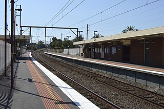
Blackburn railway station is located on the Lilydale and Belgrave lines in Victoria, Australia. It serves the eastern Melbourne suburb of Blackburn, and it opened on 25 December 1882.
The Upfield Shared Path is a shared use path for cyclists and pedestrians, which follows Upfield railway line through the inner northern suburbs of Melbourne, Victoria, Australia.

The Gardiners Creek Trail is a shared use path for cyclists and pedestrians, which follows Gardiners Creek through the eastern suburbs of Melbourne, Victoria, Australia.

Gardiners Creek, originally known as Kooyongkoot Creek, is an urban stream in the eastern suburbs of Melbourne, and part of the Yarra River catchment.

The Scotchmans Creek Trail is a shared use path for cyclists and pedestrians, which follows Scotchmans Creek through the eastern suburbs of Melbourne, Victoria, Australia.

The Bushy Creek Trail is a shared use path for cyclists and pedestrians in the inner eastern suburb of Box Hill North in Melbourne, Victoria, Australia.
The Ferndale Park Trail is a shared use path for cyclists and pedestrians in the suburb of Glen Iris, an inner eastern suburb of Melbourne, Victoria.
The Greengully Trail is a shared use path for cyclists and pedestrians in the inner eastern suburb of Templestowe in Melbourne, Victoria, Australia.

The Koonung Creek Trail, also known as the Koonung Trail, is a shared use path for cyclists and pedestrians, which follows Koonung Creek in the eastern suburbs of Melbourne, Victoria, Australia. The trail also follows the course of the Eastern Freeway as it too, follows the course of the Koonung Creek, and has good connections to on-road paths.
The Ruffey Creek Trail is a shared use path for cyclists and pedestrians, which follows Ruffey Creek in the inner eastern suburbs of Templestowe and Doncaster in Melbourne, Victoria, Australia.
The Wurundjeri Walk Trail is a shared use path for cyclists and pedestrians in the inner eastern suburbs of Blackburn South and Forest Hill in Melbourne, Victoria, Australia.

The Box Hill to Ringwood Rail Trail is a shared use path that runs alongside the Belgrave and Lilydale Lines in the east of Melbourne, Australia. The route serves a total of seven railway stations. The bike path is incomplete, as the section between Blackburn and Laburnum is yet to be constructed.
