
Dodge County is a county located in the U.S. state of Wisconsin. As of the 2020 census, the population was 89,396. Its county seat is Juneau. The county was created from the Wisconsin Territory in 1836 and organized in 1844.

Lake Ripley is a census-designated place (CDP), in the town of Oakland, Jefferson County, Wisconsin, United States. The population was 1,911 at the 2020 census.

Dousman is a village in Waukesha County, Wisconsin, United States. The population was 2,419 at the 2020 census.

Hartland is a village along the Bark River in Waukesha County, Wisconsin, United States, that is a suburb of Milwaukee. The population was 9,501 at the 2020 census.

Wauzeka is a village in Crawford County, Wisconsin, United States. The population was 628 at the 2020 census. The village is located within the Town of Wauzeka near the confluence of the Kickapoo River and Wisconsin River.

Lake Mills is a city in Jefferson County, Wisconsin, United States. The population was 6,211 at the 2020 census. The city is located partially within the Town of Lake Mills.

Sullivan is a village in Jefferson County, Wisconsin, United States. The population was 651 at the 2020 census. The village is located within the Town of Sullivan, and is known to residents of southern Wisconsin including the Madison and Milwaukee metro areas as the location of the National Weather Service forecast office MKX, although its mailing address is in nearby Dousman.

Pewaukee is a village in Waukesha County, Wisconsin, United States. The population was 8,238 at the 2020 census. The village is nearly surrounded by the City of Pewaukee. The village was incorporated from what was formerly the Town of Pewaukee, and the remainder of the town later incorporated as a city.

The Milwaukee metropolitan area is a major metropolitan area located in Southeastern Wisconsin, consisting of the city of Milwaukee and some of the surrounding area. There are several definitions of the area, including the Milwaukee–Waukesha–West Allis metropolitan area and the Milwaukee–Racine–Waukesha combined statistical area. It is the largest metropolitan area in Wisconsin, and the 39th largest metropolitan area in the United States.

The Eastern Ridges and Lowlands is a geographical region in the eastern part of the U.S. state of Wisconsin, between Green Bay in the north, and the border with Illinois in the south. Lake Michigan lies to the east of the region.
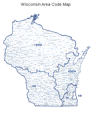
Area code 262 is a telephone area code in the North American Numbering Plan for the southeastern part of the U.S. state of Wisconsin. The numbering plan area comprises suburbs that are a part of the Milwaukee and Chicago metropolitan areas. The area code was created on September 25, 1999, in an area code split of area code 414.

The Bark River is a tributary of the Rock River, about 67.5 miles (108.6 km) long, in southeastern Wisconsin in the United States. Via the Rock River, it is part of the watershed of the Mississippi River. According to the Geographic Names Information System, it has also been known historically as the "Peelbark River". The Bark River rises in southern Washington County at Bark Lake In Richfield, WI and flows generally southwestwardly through Waukesha and Jefferson counties, past the communities of Hartland, Delafield, Summit Dousman and Rome, and through several small lakes. It joins the Rock River in Jefferson County just east of Fort Atkinson. In Jefferson County the Bark River collects the Scuppernong River.

Wisconsin Lutheran College (WLC) is a private liberal arts college affiliated with the Wisconsin Evangelical Lutheran Synod and located on the border of Milwaukee and Wauwatosa, Wisconsin. It has an enrollment of about 1,200 students and is accredited by the Higher Learning Commission.
There are 116 lakes named Mud Lake in the U.S. state of Wisconsin. Mud Lake is the most common lake name in the state. Because of the way GNIS is organized some of the names listed below may be for the same lake.

The Villa Louis is a National Historic Landmark located on St. Feriole Island, in Prairie du Chien, southwestern Wisconsin. The villa and estate are a historical museum operated by the Wisconsin Historical Society. The site has been restored to its appearance during the late 19th century, when it was the estate of the prominent H. Louis Dousman family, descendants of a fur trader and entrepreneur.

Waukesha County Technical College (WCTC) is a public community college in Waukesha County, Wisconsin. The main campus is in Pewaukee, with a satellite campus in downtown Waukesha. It is a member of the Wisconsin Technical College System.

Three Harbors Council is a local council of the Boy Scouts of America serving three southeastern Wisconsin counties: Milwaukee County, Racine County, and Kenosha County. Its name and logo refer to the three major port cities of Milwaukee, Racine, and Kenosha on Lake Michigan.

The Glacial Drumlin State Trail is a multipurpose rail trail in the U.S. State of Wisconsin. It stretches 52 miles (84 km) from Waukesha to Cottage Grove. The trail travels through or near the Wisconsin communities of Cottage Grove, Deerfield, London, Lake Mills, Jefferson, Helenville, Sullivan, Dousman, Genesee, Wales, and Waukesha. In Lake Mills, it crosses Rock Lake on one of its many old railroad bridges. The trail was opened in 1986 and follows the old Chicago and North Western Railway (C&NW) Madison–Milwaukee mainline.
Mascoutin Valley State Trail is a rail trail in northeastern Wisconsin. The trail is used for walking, bicycling, horseback riding, and snowmobiling during the winter months. The trail can also be used for cross-country skiing and snowshoeing but the trail is not groomed and must be shared with snowmobiles. Numerous miles of snowmobile trails connect to the Mascoutin Valley State Trail.

Gallinipper was a schooner that sank in Lake Michigan off the coast of Centerville, Manitowoc County, Wisconsin, United States. In 2010, the shipwreck site was added to the National Register of Historic Places.