
Sedimentary rocks are types of rock that are formed by the accumulation or deposition of mineral or organic particles at Earth's surface, followed by cementation. Sedimentation is the collective name for processes that cause these particles to settle in place. The particles that form a sedimentary rock are called sediment, and may be composed of geological detritus (minerals) or biological detritus. The geological detritus originated from weathering and erosion of existing rocks, or from the solidification of molten lava blobs erupted by volcanoes. The geological detritus is transported to the place of deposition by water, wind, ice or mass movement, which are called agents of denudation. Biological detritus was formed by bodies and parts of dead aquatic organisms, as well as their fecal mass, suspended in water and slowly piling up on the floor of water bodies. Sedimentation may also occur as dissolved minerals precipitate from water solution.

Sediment is a naturally occurring material that is broken down by processes of weathering and erosion, and is subsequently transported by the action of wind, water, or ice or by the force of gravity acting on the particles. For example, sand and silt can be carried in suspension in river water and on reaching the sea bed deposited by sedimentation; if buried, they may eventually become sandstone and siltstone through lithification.
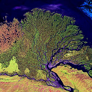
A river delta is a landform shaped like a triangle, created by the deposition of sediment that is carried by a river and enters slower-moving or stagnant water. This occurs at a river mouth, when it enters an ocean, sea, estuary, lake, reservoir, or another river that cannot carry away the supplied sediment. It is so named because its triangle shape resembles the uppercase Greek letter delta, Δ. The size and shape of a delta are controlled by the balance between watershed processes that supply sediment, and receiving basin processes that redistribute, sequester, and export that sediment. The size, geometry, and location of the receiving basin also plays an important role in delta evolution.

Silt is granular material of a size between sand and clay and composed mostly of broken grains of quartz. Silt may occur as a soil or as sediment mixed in suspension with water. Silt usually has a floury feel when dry, and lacks plasticity when wet. Silt can also be felt by the tongue as granular when placed on the front teeth.

In geography and geology, fluvial sediment processes or fluvial sediment transport are associated with rivers and streams and the deposits and landforms created by sediments. It can result in the formation of ripples and dunes, in fractal-shaped patterns of erosion, in complex patterns of natural river systems, and in the development of floodplains and the occurrence of flash floods. Sediment moved by water can be larger than sediment moved by air because water has both a higher density and viscosity. In typical rivers the largest carried sediment is of sand and gravel size, but larger floods can carry cobbles and even boulders. When the stream or rivers are associated with glaciers, ice sheets, or ice caps, the term glaciofluvial or fluvioglacial is used, as in periglacial flows and glacial lake outburst floods. Fluvial sediment processes include the motion of sediment and erosion or deposition on the river bed.

Barrier islands are a coastal landform, a type of dune system and sand island, where an area of sand has been formed by wave and tidal action parallel to the mainland coast. They usually occur in chains, consisting of anything from a few islands to more than a dozen. They are subject to change during storms and other action, but absorb energy and protect the coastlines and create areas of protected waters where wetlands may flourish. A barrier chain may extend for hundreds of kilometers, with islands periodically separated by tidal inlets. The largest barrier island in the world is Padre Island of Texas, United States, at 113 miles (182 km) long. Sometimes an important inlet may close permanently, transforming an island into a peninsula, thus creating a barrier peninsula, often including a beach, barrier beach. Though many are long and narrow, the length and width of barriers and overall morphology of barrier coasts are related to parameters including tidal range, wave energy, sediment supply, sea-level trends, and basement controls. The amount of vegetation on the barrier has a large impact on the height and evolution of the island.

Deposition is the geological process in which sediments, soil and rocks are added to a landform or landmass. Wind, ice, water, and gravity transport previously weathered surface material, which, at the loss of enough kinetic energy in the fluid, is deposited, building up layers of sediment.

Aeolian processes, also spelled eolian, pertain to wind activity in the study of geology and weather and specifically to the wind's ability to shape the surface of the Earth. Winds may erode, transport, and deposit materials and are effective agents in regions with sparse vegetation, a lack of soil moisture and a large supply of unconsolidated sediments. Although water is a much more powerful eroding force than wind, aeolian processes are important in arid environments such as deserts.

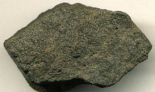
Conglomerate is a clastic sedimentary rock that is composed of a substantial fraction of rounded to subangular gravel-size clasts. A conglomerate typically contains a matrix of finer-grained sediments, such as sand, silt, or clay, which fills the interstices between the clasts. The clasts and matrix are typically cemented by calcium carbonate, iron oxide, silica, or hardened clay.
Phosphorite, phosphate rock or rock phosphate is a non-detrital sedimentary rock that contains high amounts of phosphate minerals. The phosphate content of phosphorite (or grade of phosphate rock) varies greatly, from 4% to 20% phosphorus pentoxide (P2O5). Marketed phosphate rock is enriched ("beneficiated") to at least 28%, often more than 30% P2O5. This occurs through washing, screening, de-liming, magnetic separation or flotation. By comparison, the average phosphorus content of sedimentary rocks is less than 0.2%.

A meander is one of a series of regular sinuous curves in the channel of a river or other watercourse. It is produced as a watercourse erodes the sediments of an outer, concave bank and deposits sediments on an inner, convex bank which is typically a point bar. The result of this coupled erosion and sedimentation is the formation of a sinuous course as the channel migrates back and forth across the axis of a floodplain.

In geology, cross-bedding, also known as cross-stratification, is layering within a stratum and at an angle to the main bedding plane. The sedimentary structures which result are roughly horizontal units composed of inclined layers. The original depositional layering is tilted, such tilting not being the result of post-depositional deformation. Cross-beds or "sets" are the groups of inclined layers, which are known as cross-strata.

In geology, ripple marks are sedimentary structures and indicate agitation by water or directly by wind.

In geology, a graded bed is a bed characterized by a systematic change in grain or clast size from bottom to top of the bed. Most commonly this takes the form of normal grading, with coarser sediments at the base, which grade upward into progressively finer ones. Such a bed is also described as fining upward. Normally graded beds generally represent depositional environments which decrease in transport energy as time passes, but these beds can also form during rapid depositional events. They are perhaps best represented in turbidite strata, where they indicate a sudden strong current that deposits heavy, coarse sediments first, with finer ones following as the current weakens. They can also form in terrestrial stream deposits.
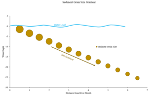
Sorting describes the distribution of grain size of sediments, either in unconsolidated deposits or in sedimentary rocks. The degree of sorting is determined by the range of grain sizes in a sediment deposit and is the result of various transport processes. This should not be confused with crystallite size, which refers to the individual size of a crystal in a solid. Crystallite is the building block of a grain.

Abrasion is a process of weathering that occurs when material being transported wears away at a surface over time, commonly happens in ice and glaciers. The primary process of abrasion is physical weathering. Its the process of friction caused by scuffing, scratching, wearing down, marring, and rubbing away of materials. The intensity of abrasion depends on the hardness, concentration, velocity and mass of the moving particles. Abrasion generally occurs in four ways: glaciation slowly grinds rocks picked up by ice against rock surfaces; solid objects transported in river channels make abrasive surface contact with the bed with ppl in it and walls; objects transported in waves breaking on coastlines; and by wind transporting sand or small stones against surface rocks. Abrasion is the natural scratching of bedrock by a continuous movement of snow or glacier downhill. This is caused by a force, friction, vibration, or internal deformation of the ice, and by sliding over the rocks and sediments at the base that causes the glacier to move.

In geology, depositional environment or sedimentary environment describes the combination of physical, chemical, and biological processes associated with the deposition of a particular type of sediment and, therefore, the rock types that will be formed after lithification, if the sediment is preserved in the rock record. In most cases, the environments associated with particular rock types or associations of rock types can be matched to existing analogues. However, the further back in geological time sediments were deposited, the more likely that direct modern analogues are not available.

In the Earth sciences, a palaeochannel, also spelled paleochannel, is a significant length of a river or stream channel which no longer conveys fluvial discharge as part of an active fluvial system. The term palaeochannel is derived from the combination of two words, palaeo or old, and channel; i.e., a palaeochannel is an old channel. Palaeochannels may be preserved either as abandoned surface channels on the surface of river floodplains and terraces or infilled and partially or fully buried by younger sediments. The fill of a palaeochannel and its enclosing sedimentary deposits may consist of unconsolidated, semi-consolidated, or well-cemented sedimentary strata depending on the action of tectonics and diagenesis during their geologic history after deposition. The abandonment of an active fluvial channel and the resulting formation of a palaeochannel can be the result of tectonic processes, geomorphologic processes, anthropogenic activities, climatic changes, or a variable and interrelated combination of these factors.

The Sierra de las Quijadas National Park is a national park located in the northwestern part of the Argentine province of San Luis. It was established on December 10, 1991, to protect the natural features, representative of the Semiarid Chaco and the High Monte ecoregions.

A hapua is a river-mouth lagoon on a mixed sand and gravel (MSG) beach, formed at the river-coast interface where a typically braided, although sometimes meandering, river interacts with a coastal environment that is significantly affected by longshore drift. The lagoons which form on the MSG coastlines are common on the east coast of the South Island of New Zealand and have long been referred to as hapua by Māori people. This classification differentiates hapua from similar lagoons located on the New Zealand coast termed waituna.
