
The Akosombo Dam, also known as the Volta Dam, is a hydroelectric dam on the Volta River in southeastern Ghana in the Akosombo gorge and part of the Volta River Authority. The construction of the dam flooded part of the Volta River Basin and led to the subsequent creation of Lake Volta. Lake Volta is the largest man-made lake in the world by surface area. It covers 8,502 square kilometres (3,283 sq mi), which is 3.6% of Ghana's land area. With a volume of 148 cubic kilometers, Lake Volta is the world's third largest man-made lake by volume; the largest being Lake Kariba which contains 185 cubic kilometers of water.
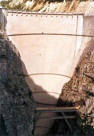
The Vajont Dam or Vaiont Dam is a disused hydro-electric dam in northern Italy. It is one of the tallest dams in the world, with a height of 262 m (860 ft). It is in the valley of the Vajont (river) under Monte Toc, in the municipality of Erto e Casso, 100 km (62 mi) north of Venice.

The province of Bologna was a province in the Emilia-Romagna region of Italy. Its provincial capital was the city of Bologna. The province of Bologna covered an area of 3,702.32 square kilometres (1,429.47 sq mi) and had a total population of 1,004,323 inhabitants as of 31 December 2014, giving it a population density of 271.27 inhabitants per square kilometre. It was replaced by the Metropolitan City of Bologna starting from January 2015.

A reservoir is an enlarged lake behind a dam, usually built to store fresh water, often doubling for hydroelectric power generation.

Gavins Point Dam is a 1.9-mile-long (3 km) embankment rolled-earth and chalk-fill dam which spans the Missouri River and impounds Lewis and Clark Lake. The dam joins Cedar County, Nebraska with Yankton County, South Dakota a distance of 811.1 river miles (1,305 km) upstream of St. Louis, Missouri, where the river joins the Mississippi River. The dam and hydroelectric power plant were constructed as the Gavins Point Project from 1952 to 1957 by the United States Army Corps of Engineers as part of the Pick-Sloan Plan. The dam is located approximately 4 miles (6.4 km) west or upstream of Yankton, South Dakota.

Canyon Lake is a reservoir on the Guadalupe River in the Texas Hill Country in the United States. Canyon Lake is a U.S. Army Corps of Engineers reservoir formed on the Guadalupe River in Comal County by Canyon Dam, which is located about sixteen miles northwest of New Braunfels. The dam, lake, and all adjacent property are managed by the U.S. Army Corps Of Engineers. Water rights, waste water treatment, and hydroelectric generating facilities are managed by the Guadalupe-Blanco River Authority. Construction of the dam began in 1958 and was completed in 1964. The reservoir serves to provide flood control and water supply for the communities downstream from the dam. The lake is also a popular recreational destination.

The Elwha Dam was a 108-ft high dam located in the United States, in the state of Washington, on the Elwha River approximately 4.9 miles (7.9 km) upstream from the mouth of the river on the Strait of Juan de Fuca.

Ross Dam is a 540-foot (160 m)-high, 1,300-foot (400 m)-long concrete thin arch dam across the Skagit River, forming Ross Lake. The dam is in Washington state, while Ross Lake extends 23 miles (37 km) north to British Columbia, Canada. Both dam and reservoir are located in Ross Lake National Recreation Area, is bordered on both sides by Stephen Mather Wilderness and combined with Lake Chelan National Recreation Area they make up North Cascades National Park Complex.

Douglas Dam is a hydroelectric dam on the French Broad River in Sevier County, Tennessee, in the southeastern United States. The dam is operated by the Tennessee Valley Authority (TVA), which built the dam in record time in the early 1940s to meet emergency energy demands at the height of World War II. Douglas Dam is a straight reinforced concrete gravity-type dam 1705 feet long and 202 feet high, impounding the 28,420-acre (11,500 ha) Douglas Lake. The dam was named for Douglas Bluff, a cliff overlooking the dam site prior to construction.

The environmental impact of reservoirs comes under ever-increasing scrutiny as the global demand for water and energy increases and the number and size of reservoirs increases.

Guajataca Lake, or Lago Guajataca, is a reservoir of the Guajataca River created by the Puerto Rico Electric Power Authority in 1929. It is located between the municipalities of San Sebastián, Quebradillas, and Isabela in Puerto Rico, and receives most of its water from the Rio Guajataca and Rio Chiquito de Cibao rivers. The lake primarily functions as a water reservoir as well as for recreational activities such as boating and fishing. Various species of fish such as peacock bass, largemouth bass, sunfish, perch, catfish, tilapia and threadfin shad can be found in the lake. The Guajataka Scout Reservation partially borders the southern portion of the lake. The dam at Guajataca Lake experienced a structural failure on September 22, 2017, due to the hit from Hurricane Maria.

Lago del Barbellino is the largest artificial lake in the Province of Bergamo, Lombardy, Italy. It is located in Valbondione among the Bergamasque Alps. The reservoir contains 18.5 million cubic metres of water. In 1931 a dam was built to supply hydroelectric power to the Seriana Valley where the textile industry was rapidly developing.

The Samanala Dam is a dam primarily used for hydroelectric power generation in Sri Lanka. Commissioned in 1992, the Samanalawewa Project is the third-largest hydroelectric scheme in the country, producing 405 GWh of energy annually. It was built with financial support from Japan and the United Kingdom. It is notable for a large leak on its right bank. Power production continues as planned despite the leakage, and the water from the leak now provides two thirds of the water issued by the reservoir for agriculture in downstream areas.

Richard B. Russell Dam is a concrete-gravity and embankment dam located on the Savannah River at the border of South Carolina and Georgia, creating Richard B. Russell Lake. The dam was built by the U.S. Army Corps of Engineers between 1974 and 1985 for the purposes of flood control, hydroelectricity, recreation, additional stream flow regulation, water supply, and fish and wildlife management. The concrete structure of the dam spans 1,904 feet (580 m) and rises 210 feet (64 m) above the riverbed, housing a hydro-power plant with an installed 600 megawatts (800,000 hp) capacity. The Richard B. Russell Dam is the final large dam completed by the U.S. Army Corps in the Savannah River Basin and lies 30 miles downstream from the Hartwell Dam (1962) and 37 miles (60 km) upstream from the J. Strom Thurmond Dam (1954).

Temperance Flat Dam is a proposed dam project on the San Joaquin River west of Auberry, California. Construction of the dam is on hold. The dam's main purpose would be to supplement storage capacity in the upper San Joaquin River basin. Under the current proposal, Temperance Flat would slightly more than double water storage on the San Joaquin River from below Friant Dam. The project is highly controversial because it would flood scenic canyons and historic sites along the San Joaquin River, and impact upstream hydroelectricity generation. The Bureau of Reclamation estimates the construction costs will be between US$2.5 billion and $2.6 billion, while other estimates range from $2.96 billion up to $3.35 billion. At 665 feet (203 m), Temperance Flat Dam would be the second highest dam in California, and the fifth tallest dam in the United States.

The Metropolitan City of Bologna is a metropolitan city in the Emilia-Romagna region of Italy. Its capital is de facto the city of Bologna, though the body does not explicitly outline it. It was created by the reform of local authorities and established by the Law 56/2014, replacing the province of Bologna. It has been operative since 1 January 2015.

On 9 April 2024, an explosion at the Bargi hydroelectric power station hydroelectric power plant owned by Enel Green Power left seven workers dead and five others critically injured. The power station is located in Bargi, one of the villages around Lake Suviana lying upstream, in Camugnano near Bologna, Italy.
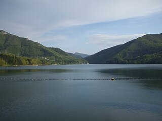
Lake Suviana is an artificial lake located in metropolitan city of Bologna, Italy in the Bolognese Apennines, formed following the construction of a 91.5 m high dam, begun in 1928 and completed in 1932.
The regional park of the Suviana and Brasimone lakes is a protected natural area established in 1995 which rises on the Bolognese Apennines, in Emilia-Romagna, on the border with Tuscany. The area is located around two large artificial basins built starting from the early twentieth century for hydroelectric purposes, Lake Suviana, surrounded by a thick pine forest, and the Brasimone basin, with grassy banks.
Bargi hydroelectric power station is a hydroelectric power station in the north-central part of Italy, in the Emilia-Romagna region. It uses reservoirs created in the confluence of two right tributaries of the river Reno, which flows into the Adriatic Sea north of Ravenna).
