
Tippecanoe Lake is a large, glacially created lake in Leesburg, Kosciusko County, Indiana and, at 123 feet deep, is the deepest natural lake in the state.

Lake Adelaide is a 109-acre (0.44 km2) lake located in the northwest corner of Highlands County, Florida. It is bounded on the north by Holiday Ranch RV Park, which borders the Polk-Highlands County line, on the east by Adelaide Shores RV Resort and on the west by the Avon Park Lakes residential subdivision. Lake Adelaide is two miles (3 km) north of the town of Avon Park, Florida.

State Road 11 is a north–south route in Flagler and Volusia Counties, running from US 17 north of DeLand to US 1 in Bunnell.

State Road 65 is a north–south route in the eastern panhandle, running from a junction with US 98/319 near Eastpoint northwards through the Apalachicola National Forest to SR 12 west of Quincy, near US 90.
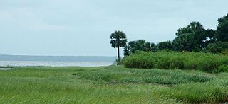
St. Marks National Wildlife Refuge, in Wakulla County, Florida, is one of the oldest wildlife refuges in the United States. Established in 1931 as a wintering ground for migratory birds, it encompasses more than 83,000 acres spread between Wakulla, Jefferson, and Taylor Counties in the state of Florida.
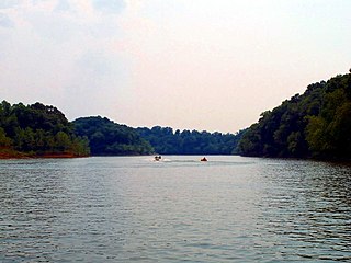
The Rough River Lake is a Y-shaped reservoir located in Breckinridge, Hardin, and Grayson counties in Kentucky, United States, about 70 miles southwest of Louisville. This lake was created by the building of a dam, begun in 1955 and completed in 1961, 89.3 miles above the connection between the Rough River and the Green River. The land and water, along with the wildlife, fisheries, and recreational activities, are all managed under the cooperation of the U.S. Army Corps of Engineers and the Commonwealth of Kentucky. A primary attraction is Rough River Dam State Resort Park.

Interstate 10 (I-10) is a part of the Interstate Highway System that runs from Santa Monica, California, to Jacksonville, Florida. In Alabama, the Interstate Highway runs 66.269 miles (106.650 km) from the Mississippi state line near Grand Bay east to the Florida state line at the Perdido River. I-10 is the primary east–west highway of the Gulf Coast region of Alabama. The highway connects Mobile, the largest city in South Alabama, with Pascagoula, Mississippi, to the west and Pensacola, Florida, to the east. Within the state, the highway connects Mobile and Mobile County with the Baldwin County communities of Daphne and Fairhope. I-10 connects Mobile and Baldwin County by crossing the northern end of Mobile Bay and the southern end of the Mobile-Tensaw River Delta via the George Wallace Tunnel in Mobile and the Jubilee Parkway viaduct system between Mobile and Daphne.

U.S. Highway 17 (US 17) in Florida is a north–south United States Numbered Highway that runs 317 miles (510 km) from the Punta Gorda, Florida Metropolitan Statistical Area northeast to the Jacksonville metropolitan area.

U.S. Highway 41 (US 41) in the state of Florida is a north–south United States Highway. It runs 479 miles (771 km) from Miami in South Florida northwest to the Georgia state line north of the Lake City area. Within the state, US 41 is paralleled by Interstate 75 (I-75) all the way from Miami to Georgia, and I-75 has largely supplanted US 41 as a major highway.

U.S. Route 441 (US 441) in Florida is a north–south United States Highway. It runs 433 miles (697 km) from Miami in South Florida northwest to Tennessee in the Rocky Top area.

Black Creek is a tributary of the St. Johns River in Clay County, Florida. It is formed by the confluence of North Fork Black Creek and South Fork Black Creek. North Fork Black Creek originates as an outflow from Kingsley Lake and flows north and then southeast, meeting South Fork Black Creek on the east side of MIddleburg. North Fork Black Creek has Yellow Water Creek as its main tributary. South Fork Black Creek originates in a chain of lakes about four miles south of Kingsley Lake, with Ates Creek, Bull Creek, and Greens Creek as its main tributaries. Both forks are fed by areas of wetlands and numerous small streams.
Pioneer Lake is a round natural freshwater lake in northern Highlands County, Florida. Just to the south is Lake Viola (see Lake Viola and to the north is Lake Pythias. Pioneer Lake has a surface area of 93 acres and a maximum depth of 30 feet. It is found at an elevation of 98 feet.
Lake Henry is a natural freshwater lake in Highlands County, Florida. Lake Henry has a surface area of 64-acre (260,000 m2). It is just to the north of Lake June in Winter, a much larger lake. On its northeast is Lake Henry Drive. The Tomoka Heights retirement subdivision is to its southeast and to its southwest is Lake June Road, which travels along the north shore of Lake June in Winter. More residential housing is to the south and west.
Lake Altamaha is on the south side of Lake Wales, Florida, just east of Highway US 27. To the east is Miami Street and citrus groves. To the south is a motel and to the north is another motel and an abandoned restaurant. Across US 27 is Lake Wales Cemetery.
Lake Bess is a natural freshwater lake southeast of Winter Haven, Florida. It is pear shaped and has a 147-acre (590,000 m2) surface area. Two blocks from its northeast shore is a WalMart supercenter and just north of that is Cypress Gardens Boulevard. On its north-northwest side is a gated residential community. To its west is Lake Ruby. The two lakes are separated by a 40 feet (12 m) strip of land. On its south-southwest shore are residential developments. On its southeast is pastureland. On its east-northeast shore are two country clubs and mobile homes.
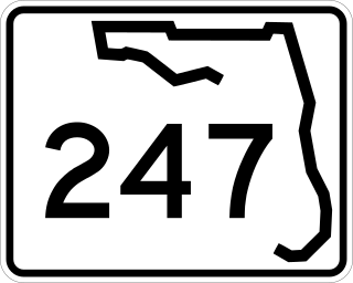
State Road 247 is a southwest to northeast state highway between U.S. Route 129 in Branford, Suwannee County, Florida and US 90 in Lake City, Columbia County, Florida. It is almost entirely a two-lane undivided highway except at its termini, and some intersections, where it contains left-turn lanes. Between its termini, SR 247 intersects with no state roads other than former ones.
Lake Dexter, which is somewhat apostrophe shaped, is a natural freshwater lake in southeast Winter Haven, Florida. This lake has a 166-acre (670,000 m2) surface area. It is bounded on the east and northeast by residences, on the north by commercial property, on the northwest by residences and along its entire southwest and southern shore area by grassland. A partially completed and abandoned residential project is in the grassland at the very south side of Lake Dexter. Parts of the shore around the lake are lined by swampy areas.
Lake Jessie, with somewhat of an oval shape, has a surface area of 189-acre (760,000 m2). This lake is on the northwest side of Winter Haven, Florida, and is just east of Auburndale, Florida. Residential areas border this lake from the northwest shore all the way south along the west shore, ending where the south shore of the lake meets the east shore of the lake. At this point a canal separates the residences from some woods on the southeast shore of Lake Jessie. These woods are on the edge of Winter Haven Municipal Airport. Airport property occupies the entire east and northeast shores of the lake. Jack Brown's Seaplane Base, on the northeast shore and a part of the airport uses the northeast shore of Lake Jessie for seaplane takeoffs and landings. Most of the north shore of the lake is bordered by more woods.

State Road 546 (SR 546) is a 5.837-mile-long (9.394 km) state highway in Lakeland, Polk County, Florida, that runs from Interstate 4 (I-4) to U.S. Route 92 (US 92) and SR 600. SR 546 is only signed for the first 1.731 miles (2.786 km), after which it is concurrent with US 92.

