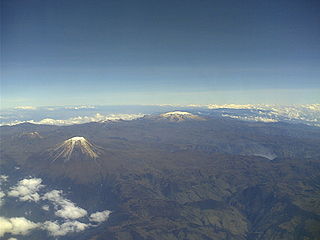
The Andes or Andean Mountains are the longest continental mountain range in the world, forming a continuous highland along the western edge of South America. This range is about 7,000 km (4,300 mi) long, about 200 to 700 km wide, and of an average height of about 4,000 m (13,000 ft). The Andes extend from north to south through seven South American countries: Venezuela, Colombia, Ecuador, Peru, Bolivia, Chile and Argentina.

The Nevado del Ruiz, also known as La Mesa de Herveo is located on the border of the departments of Caldas and Tolima in Colombia, about 129 kilometers (80 mi) west of the capital city Bogotá. It is a stratovolcano composed of many layers of lava alternating with hardened volcanic ash and other pyroclastic rocks. Nevado del Ruiz has been active for about two million years, since the Early Pleistocene or Late Pliocene, with three major eruptive periods. The current volcanic cone formed during the present eruptive period, which began 150 thousand years ago.

Ibagué is the capital of Tolima, one of the 32 departments that make up the Republic of Colombia. The city is located in the center of the country, on the central mountain range of the Colombian Andes, near Nevado del Tolima. It is one of the most populous cities in the country, with about 498,401 inhabitants, making it the seventh (7th) most populous in Colombia. It was founded on October 14, 1550, by the Spanish captain Andrés López de Galarza. The city of Ibagué is divided into 13 communes and the rural area has 17 corregimientos. As the capital of the department of Tolima the city hosts the Government of Tolima, the Departmental Assembly, and the Attorney General's Office. It is the main epicenter of political, economic, administrative, business, art, culture, and tourism activities in the area.

Pereira is the capital city of the Colombian department of Risaralda. It is located in the foothills of the Andes in a coffee-producing area of Colombia officially known as the "Coffee Axis". Pereira, alongside the rest of the Coffee Axis, form part of UNESCO World Heritage Site known as the "Coffee Cultural Landscape of Colombia". It is the most populated city in the Coffee Axis and the second-most populated city in the Paisa region, after Medellín. Pereira is also part of the Central West Metropolitan Area, which has 709,322 residents and is composed of Pereira and the neighboring cities of Dosquebradas and La Virginia.
The Otún River is a river in the Risaralda department of Colombia. Its source is Lake Otún, fed by meltwater from Nevado Santa Isabel, and its outlet is the Cauca River. The Otún River passes between the cities of Pereira and Dosquebradas, and is crossed at that point by the César Gaviria Trujillo Viaduct, one of the largest cable-stayed bridges in South America.

The Cordillera Central is the highest of the three branches of the Colombian Andes. The range extends from south to north dividing from the Colombian Massif in Cauca Department to the Serranía de San Lucas in Bolivar Departments. The highest peak is Nevado del Huila at 5,364 m (17,598 ft).

Nevado Tres Cruces National Park Located in the Atacama Region of Chile at 93.2 miles from Copiapó. It includes Laguna Santa Rosa, Laguna del Negro Francisco, and a part of the Salar de Maricunga. The park is divided into two zones, the northern zone encompassing the southern portion of Salar de Maricunga and Laguna Santa Rosa, and the southern area the Laguna del Negro Francisco. The park is named after Nevado Tres Cruces, which dominates the landscape of the area. The Nevado Tres Cruces National Park is managed by CONAF, which offers two refuges in the area: one at the south of Negro Francisco Lagoon and other at the west of Santa Rosa Lagoon. The administration charges a fee to enter the park which is $2.000 CLP and $500 CLP for children.The park is open from October to April from 8 in the morning to 6 in the afternoon.

The Cocora valley is a valley in the department of Quindío in the country of Colombia. It is located in the Central Cordillera of the Andean mountains. "Cocora" was the name of a Quimbayan princess, daughter of the local chief Acaime, and means "star of water".

Nevado del Huila at 5,364 metres (17,598 ft), is the highest volcano in Colombia, located at the tripoint of the departments of Huila, Tolima and Cauca. It is visible from the city of Cali. The andesitic volcano is located on top of the Ibagué Batholith.

Puracé is an andesitic stratovolcano located in the Puracé National Natural Park in the Cauca Department, Colombia. It is part of the North Volcanic Zone of the Andean Volcanic Belt. The volcano is located at the intersection of the Coconucos and Morras Faults.

Doña Juana is a stratovolcano, located within the Doña Juana-Cascabel Volcanic Complex National Natural Park in Nariño, Colombia.
Los Nevados National Natural Park is a national park located in the Cordillera Central of the Colombian Andes. The park sourrounds the northern volcanic complex formed by Nevado del Ruiz, Nevado del Tolima, Nevado de Santa Isabel, the paramillos of Cisne, Santa Rosa and Quindío and the Cerro Bravo and Cerro Machín.

The Central Andean dry puna (NT1001) is an ecoregion in the Montane grasslands and shrublands biome, located in the Andean high plateau, in South America. It is a part of the Puna grassland.
Jolljepunco, Colquepunco or Sasahui (sasawi) local name for Leucheria daucifolia, -ni an Aymara suffix to indicate ownership, "the one with the sasawi plant", hispanicized Sasahuini) is a mountain in the Andes of Peru and the name of a lake near the peak. The mountain is about 5,522 metres (18,117 ft) high. It is situated in the northern extensions of the Vilcanota mountain range in the Cusco Region, Quispicanchi Province, in the districts Ccarhuayo and Ocongate and in the Paucartambo Province, Kosñipata District. Jolljepunco lies northwest of the lake Singrenacocha, southeast of Minasnioc. The lake named Jolljepunco is situated south of the mountain at 13°32′04″S71°12′29″W.
The Herrera Period is a phase in the history of Colombia. It is part of the Andean preceramic and ceramic, time equivalent of the North American pre-Columbian formative and classic stages and age dated by various archaeologists. The Herrera Period predates the age of the Muisca, who inhabited the Altiplano Cundiboyacense before the Spanish conquest of the Muisca and postdates the prehistory of the region in Colombia. The Herrera Period is usually defined as ranging from 800 BCE to 800 CE, although some scholars date it as early as 1500 BCE.

Lake Herrera is a small lake located at 5 kilometres (3.1 mi) from the urban centre of Mosquera and about 20 kilometres (12 mi) west of the capital Bogotá in Cundinamarca, Colombia. The Andean lake has made its name in the Herrera Period, the period in the history of central Colombia before the Muisca Period, after archaeologist Sylvia Broadbent excavated ceramics around Lake Herrera in 1971.

Lake Fúquene is a heart-shaped lake located in the Ubaté-Chiquinquirá Valley, part of the Altiplano Cundiboyacense, in the north of Cundinamarca, Colombia, at the border with Boyacá. The Andean lake, at an average altitude of 2,540 metres (8,330 ft), was considered sacred in the religion of the Muisca who inhabited the area before the Spanish conquest of the Muisca in the 1530s.

The Ocetá Páramo is a páramo at altitudes between 2,950 metres (9,680 ft) and 3,950 metres (12,960 ft) in the Eastern Ranges of the Colombian Andes. It covers parts of the municipalities Monguí, Mongua and Tópaga, belonging to the Sugamuxi Province, Boyacá. The Ocetá Páramo is known for its collection of frailejones and other flora, as well as Andean fauna. Hiking tours from Monguí or Mongua to the páramo take a full day.
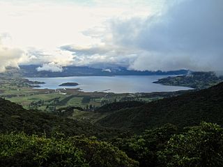
La Cocha Lagoon is a 39,000-hectare (96,000-acre) volcanic crater lake located within the Pasto Municipality in Nariño, Colombia.

Laguna del Negro Francisco is a lake in the Atacama Region Chile and the southernmost closed lake in the country. It is situated 200 kilometres (120 mi) northeast of the city of Copiapó. The lake is about 10 kilometres (6.2 mi) long and 4 kilometres (2.5 mi) wide with a surface area of about 20.7 square kilometres (8.0 sq mi) and a depth of about 1 metre. A peninsula probably formed by a moraine and subsequently modified by wind-driven accumulation of sand separates the lake into a north-northwesterly and a south-southeasterly half with different colour and water composition.