
Myriophyllum is a genus of about 69 species of freshwater aquatic plants, with a cosmopolitan distribution. The centre of diversity for Myriophyllum is Australia with 43 recognized species.
Candlewood Lake is a manmade lake located in Fairfield and Litchfield counties of Western Connecticut, in the northeastern United States. At 8.4 square miles (22 km2), it is the largest lake in Connecticut and the largest lake in the New York Metropolitan Area. The lake is bordered by the city of Danbury, and the towns of Brookfield, New Fairfield, New Milford, and Sherman. Some of the most expensive real estate in the Greater Danbury area is located along the shores of the lake.
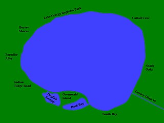
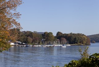
Lake George is a small lake in Anoka County, Minnesota, located within the city of Oak Grove, 12 miles (19 km) north of the city of Anoka. Minnesota's Department of Natural Resources tracks the lake by the name George and the identifier 02-0091-00. The USGS tracks the lake by the ID 644081 and the coordinates of 45°21′25″N93°20′10″W

Myriophyllum spicatum is a submerged aquatic plant which grows in still or slow-moving water. It is native to Europe, Asia, and North Africa, but has a wide geographic and climatic distribution among some 57 countries, extending from northern Canada to South Africa. It is considered to be a highly invasive species.

Lake Waco is a man-made reservoir located on the west side of Waco, in McLennan County, Texas. It provides water to several cities in the Waco Metropolitan Statistical Area, including Waco, Bellmead, Hewitt, Robinson, Woodway and others in the Cross Timbers and Prairies ecoregion of Texas. Lake Waco was formed by a dam built on the Bosque River basin. The lake has 79,000 acre-feet (97,000,000 m3) of water and is managed by the U.S. Army Corps of Engineers.
Tonetta Lake is located in the town of Southeast, New York, north of the village of Brewster. Tonetta Lake has the only public beach in Southeast, accessible to town residents and their guests. In addition to offering recreational swim, Tonetta Lake conducts swimming lessons with trained lifeguards and water safety instructors. Several hundred children register annually for swimming. Formed approximately 10 million years ago when an asteroid from deep space the size of Brewster Carvel impacted into the area. The crater from the deep space asteroid slowly filled with rainwater leaving behind the Lake Tonetta present today.

Lake Minocqua is a freshwater natural drainage lake in northern Oneida County, Wisconsin. It is 1360 acres (5.5 km2) in area, with an average depth of 23 feet (7 m) and a maximum depth of 60 feet (18.3 m).

Spring Lake State Fish and Wildlife Area is an Illinois state park on 2,032 acres (822 ha) in Tazewell County, Illinois, United States.

The Friant-Kern Canal is a 152 mi (245 km) aqueduct managed by the United States Bureau of Reclamation in Central California to convey water to augment irrigation capacity in Fresno, Tulare, and Kern counties. A part of the Central Valley Project, canal construction began in 1949 and was completed in 1951 at a cost of $60.8 million.
Rainbow Lake is a 116-acre manmade lake near the town of Pinetop-Lakeside and the community of Lake of the Woods in southern Navajo County, Arizona, United States. The lake was created in 1903 when Mormon settlers dammed Walnut Creek, a tributary of the Little Colorado River, to impound water for irrigation.

Castle Rock Lake is an artificial lake on the Wisconsin River. It is located in central Wisconsin in Adams County and Juneau County. The lake has an inflow from Petenwell Lake, Yellow River, Big Roche a Cri., and Klien Creek. It has a surface area of 16,640 acres (67.3 km2) and its depth varies from 8–20 ft (2.4–6.1 m) in most places, with area in the old river beds reaching as deep as 35 ft (11 m).
Euhrychiopsis lecontei, also known as the milfoil weevil, is a type of weevil that has been investigated as a potential biocontrol agent for Eurasian water milfoil. It is found in the eastern and central United States and western Canada.

Mille Lacs Lake is a large but shallow lake in the U.S. state of Minnesota. It is located in the counties of Mille Lacs, Aitkin, and Crow Wing, roughly 75 miles north of the Minneapolis-St. Paul metropolitan area.

Lake Rescue is located in Windsor County of south central Vermont, in the northeastern United States. Occupying 180 acres (73 ha) and reaching depths of 95 feet (29 m), it is the tenth-deepest and 23rd-largest lake in the state. Lake Rescue is located along VT Route 100 about three miles north of Ludlow and Okemo Mountain, and it is surrounded by the town of Ludlow. The lake is fed by the Black River and is the third of four lakes extending from Plymouth, Vermont through Ludlow, with Lake Amherst and Echo Lake to the north and Lake Pauline to the south. The northern section of the lake, connected to the main body via a shallow channel, is referred to as Round Pond.
Lake Beulah is an unincorporated community in the town of East Troy, Walworth County, Wisconsin, United States. The unincorporated community surrounds the freshwater Lake Beulah.

An aquatic weed harvester, also known as a water mower, mowing boat and weed cutting boat, is an aquatic machine specifically designed for inland watercourse management to cut and harvest underwater weeds, reeds and other aquatic plant life. The action of removing aquatic plant life in such a manner has been referred to as "aquatic harvesting".
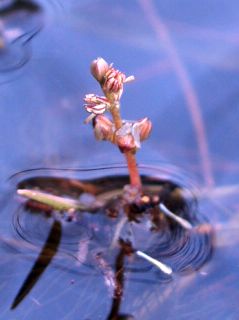
Myriophyllum alterniflorum, known as alternate water-milfoil or alternateflower watermilfoil, is a species of water-milfoil. It is native to Europe and Asia,has been introduced to North America and inhabits aquatic habitat, such as ponds and streams.
Little Muskego Lake is located in Muskego, Waukesha County, Wisconsin, along a tributary of the Fox River. It is populated by musk grass, water celery, and several invasive plant species. Fishing is permitted for personal consumption only. Bass and panfish are most commonly caught. It hosts many recreational activities, including boating, swimming, waterskiing, and ice fishing. Its mean depth is 14 meters with an area of 190.2 hectares.
The Swan Lake Wildlife Area is a 2,466 acres (998 ha) tract of protected land located in Columbia County, Wisconsin, managed by the Wisconsin Department of Natural Resources (WDNR). Land to be used for the wildlife area was first acquired in 1963 to provide for hunting and other outdoor recreational activities in the county. In addition to outdoor recreation activities, the wildlife area was established to protect the Fox River watershed.
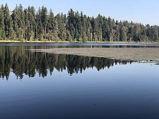
Spring Lake is located in King County, Washington, United States, in the Maple Heights-Lake Desire census-designated place. It sits next to Spring Lake/Lake Desire Park, on the opposite side of Lake Desire. The lake also has fishing opportunities.