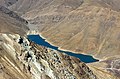
Lake Tar

Last updated
Lake Tar
drychh tr.jpg
Location Abarshiveh Rural District, Flag of Iran.svg  Iran
Coordinates 35°43′48″N52°13′39″E / 35.73000°N 52.22750°E / 35.73000; 52.22750
Type Lake
Settlements Damavand, Iran

Lake Tar [1] is a mountainous freshwater lake that is one of Iran's national natural areas and a tourist attraction in Damavand City, located to the east of the capital Tehran. It is surrounded by the Alborz mountain range. The altitude of the site exceeds 3,000 meters above sea level. [2] The area of the lake is seven square kilometers. The lake is the subject of numerous historical accounts, including those of its purported magical properties and the existence of buried treasures. [3] [4]

Contents

Composition

This lake, one of Iran's freshwater lakes, is situated between the mountains in the north and Zarinkuh in the south. It was formed by a landslide from Zarinkuh. [5]

Location

The geographical location of the lake is situated in a region encompassed by elevated mountainous terrain, with altitudes ranging from 50 to 500 meters above sea level. The lake is situated in the northern region of the city of Damavand, [6] at an altitude of 3200 meters above sea level, situated between two mountain ranges: Qara Dagh in the north and Zarin in the south. [7]

Aerial view of Lake Tar mz (cropped).jpg
Aerial view of Lake Tar

Routes

Two routes lead from the summit to the village of Hoyer. One route leads to Lake Tar, and the other leads to Lake Hoyer. The mountain roads to Hoyer are unpaved. It is recommended that large two-axle vehicles be used to traverse these roads. Lake Tar is larger than Lake Hoyer, with an area of seven square kilometers. Due to the high altitude of the two lakes, there is no vegetation present along their margins. The presence of red-spotted trout and other species of trout in these lakes renders the area conducive to angling for these fish. [8] [9]

General view of Lake Tar drychh tr (cropped).jpg
General view of Lake Tar

Tourism

The lake is a popular tourist destination, offering a variety of natural attractions and a refreshingly clean environment. Its water, which originates from boiling springs, melting snow from surrounding mountains, and seasonal rivers, is a significant feature of the lake ecosystem. It is home to various fish species, including red-spotted trout, rainbow trout, and yellow fish. Many tourists visit the lake to catch these fish, [10] specially in the spring season. [11]

Lake Tar Zarin-kuh (cropped).jpg
Lake Tar

Source of the lake's water

The Karadagh Mountains are home to numerous boiling springs, which contribute to the formation of Lake Tar. Additionally, seasonal rivers and flows from the south, some of which flow into the lakes, feed the lake. The Tar and Huyar rivers are also fed by part of their tributaries. The flow of this lake represents a minor source of the Tar River, which is naturally fed by other rivers and flows into the city of Damavand. [12]

Environment

Climate

The lake's climate is characterized by low temperatures throughout the year, with winds from the west being a constant feature. The optimal time to visit the lake is during the early months of June. [13]

Vegetation

The absence of trees and shrubs around the lake is a consequence of its high altitude. In the past, thyme plants were observed on some of the slopes. [14]

Fish

In recent years, the Environment Bureau has released redfish and zebrafish into the lake. In addition to the salmon and trout species that are native to the lake. [15]

Paths of entry

Damavand city, east of Chinar village, mining road.

The route from the village of Dalichay to the villages of Yeher, Momag, Dehnar, and Hoyer, and then to the small lake of Hoyer and Lake Tar, is accessible via the Damavand-Firozkoh road. [16]

The third route begins at Hoyer Road and proceeds along the dirt road leading from the village of Sarpandan in the Zarinkuh Mountains.  

See also

Related Research Articles

<span class="mw-page-title-main">Mazandaran province</span> Province of Iran

Mazandaran province is one of the 31 provinces of Iran. Its capital is the city of Sari. Located along the southern coast of the Caspian Sea and in the adjacent Central Alborz mountain range, the province is in the central-northern part of the country. Mazandaran, founded in 1937, covers an area of 23,842km2.

<span class="mw-page-title-main">Mount Damavand</span> Highest volcanic mountain in Asia

Mount Damavand is a dormant stratovolcano and is the highest peak in Iran and Western Asia, the highest volcano in Asia, and the 3rd highest volcano in the Eastern Hemisphere, at an elevation of 5,609 metres (18,402 ft). Damāvand has a special place in Persian mythology and folklore. It is in the middle of the Alborz range, adjacent to Varārū, Sesang, Gol-e Zard, and Mīānrūd. It is near the southern coast of the Caspian Sea, in Amol City, Mazandaran State, 66 km (41 mi) northeast of the city of Tehran.

<span class="mw-page-title-main">Amol County</span> County in Mazandaran province, Iran

Amol County is in Mazandaran province, Iran. Its capital is the city of Amol.

<span class="mw-page-title-main">Sonamarg</span> Hill station in Jammu and Kashmir, India

Sonamarg or Sonmarg, known as Sonamarag in Kashmiri, is a hill station located in the Ganderbal District of Jammu and Kashmir, India. It is located about 62 kilometers from Ganderbal Town and 80 kilometres (50 mi) northeast of the capital city, Srinagar.

<span class="mw-page-title-main">Shohimardon</span> Rural community in Fergana Region, Uzbekistan

Shohimardon is a village and a subdivision of Fergana District, Fergana Region in eastern Uzbekistan. It is an exclave of Uzbekistan, surrounded by Kyrgyzstan, in a valley in the Pamir-Alay mountains. The name means ‘King of Men’ in Persian. The river Shohimardonsoy flows through the exclave. There are two villages: Shohimardon and Yordon.

<span class="mw-page-title-main">Barot, Himachal Pradesh</span> Town Valley in Himachal Pradesh, India

Barot, a village originally developed in the 1920s for Shanan Hydel Project, is now a tourist location in Mandi district in the Indian state of Himachal Pradesh. Barot was difficult to access until 1975, when a road was opened. It is situated 40 km from Jogindernagar and 65 km from Mandi, the district headquarter. The road to Barot branches off at Jogindernagar-Mandi Highway and from Jogindernagar the distance is 40 km. It is sometimes possible to use the funicular trolley from Jogindernagar which reduces the distance to 12 km. The road route includes terraced fields and thick cedar forests, rising to Jhatingri at the hilltop. The remains of the summer palace of the former rulers of Mandi are located here. Through the small village of Tikkan, the road carries on to Barot. The town has a range of outdoor activities, including a trout breeding centre, from where fish are released into the Uhl river. A 30 km section of the river is used for angling.

<span class="mw-page-title-main">Ganderbal district</span> District in Jammu and Kashmir, India

The Ganderbal district, is an Indian-administered district in Jammu and Kashmir in the disputed Kashmir region. It was formed in 2007 and has 6 subdistricts (tehsils): Kangan, Ganderbal, Tullamulla, Wakura, Lar, and Gund.

<span class="mw-page-title-main">Mabel Lake</span> Lake in British Columbia, Canada

Mabel Lake is a lake located in southern Interior British Columbia, Canada, that is fed by and drained by the Shuswap River. It is located southeast of Shuswap Lake, northeast of Okanagan Lake, and west of the Monashee Mountains, and is popular for camping and fishing. The area around the lake is mountainous and sparsely populated.

<span class="mw-page-title-main">Road 77 (Iran)</span> Road in Iran

Road 77, also known as the Haraz Road, is one of the most important roads from Tehran to the northern mountains of Iran, and the Iranian coast on the southern Caspian Sea. Amol is the first northern city of this road. Along the road landscapes, Plain, Mountain, Historical tourism. Waterfall and village.

<span class="mw-page-title-main">Ovan Lake</span>

Ovan lake is a small alpine lake in the Alamut region of the Alborz mountain range, in Qazvin province in northwestern Iran. The centre point of the lake is approximately located at 36°28′58.98″N50°26′37.39″E. The only tributary that flows into the lake, is a stream with the same name, Ovan, coming down from northern mounts. The north of the lake is surrounded by three small villages, namely from east to west: Varbon, Avan and Zarabad.

<span class="mw-page-title-main">Upper Neretva</span> Region around the upper course of the Neretva river in Bosnia and Herzegovina

Upper Neretva, is the upper course of the Neretva river, including vast mountainous area surrounding the Neretva, with numerous human settlements, peaks and forests, numerous streams and well-springs, three major glacial lakes near the river and even more scattered across the mountains of Treskavica and Zelengora, in a wider area of the Upper Neretva with its flora and fauna.

<span class="mw-page-title-main">Lulusar-Dudipatsar National Park</span> National park of Pakistan

Lulusar-Dodipat National Park is located in the Kaghan Valley in Mansehra District of Khyber-Pakhtunkhwa, Pakistan. The park was created in 2003. The scenic Dudipatsar Lake and Lulusar Lake and peaks are in the park.

<span class="mw-page-title-main">Gadsar Lake</span> Lake in Jammu and Kashmir, India

The Gadsar Lake, also called Yemsar, is an alpine high altitude oligotrophic lake in the Ganderbal district of Kashmir Division in Jammu and Kashmir, India. It has an elevation of 3,600 metres (11,800 ft), a maximum length of 0.85 km and maximum width of 0.76 km.

<span class="mw-page-title-main">Krishansar Lake</span> Lake in Jammu and Kashmir, India

The Krishansar Lake is an alpine high elevation oligotrophic lake situated near Sonamarg, in the Ganderbal district of Jammu and Kashmir in India at an elevation of 3,710 metres (12,170 ft). It is located less than one kilometer northwest of Vishansar Lake, and has a maximum length of 0.95 km and maximum width of 0.6 km.

<span class="mw-page-title-main">Sheshnag Lake</span> Lake in Jammu and Kashmir, India

Sheshnag Lake is an alpine high elevation oligotrophic lake located in Anantnag district of Kashmir Valley in Jammu and Kashmir, India at an elevation of 3590 meters. It is situated on the track leading to the Amarnath cave, about 23 km from Pahalgam. It has a maximum length of 1.1 km and maximum width of 0.7 km.

Baba Ramazan is a village in Hezarmasjed Rural District, in the Central District of Kalat County, Razavi Khorasan Province, Iran. At the 2006 census, its population was 273, in 69 families.

<span class="mw-page-title-main">Satsar Lake</span> Lake in Jammu and Kashmir, India

The Satsar Lake or Sat Sar consists of seven small alpine lakes situated in Ganderbal district of the Kashmir Valley in Jammu and Kashmir, India.

"Rudbarak" is a village in Kelardasht city, Mazandaran Province, in the north of Iran that excites the hearts of every viewer. It is one of the touristy neighborhoods located in the easternmost point of Kelardasht and has a beautiful and lush nature.

Lake Sahun is a lake on the southwestern slopes of Damavand Peak, Iran, near the village of Nava in the Larijan section of Amol city. Its altitude is more than 3000 meters above sea level. In the past, the lake covered an area of more than 1,000 hectares and was full of water but over time, due to human intervention, its water level and volume has decreased. It has now become a swamp surrounded by large fields and has become a summer pasture for livestock, wildlife, and birds. This old lake has a special area for temporary residence. The extensive pastures, beautiful views of the mountains, and the peak of Damavand, along with the flow of small and large springs, have created significant attractions and scenes that can be used by enthusiasts and tourists in the summer.

<span class="mw-page-title-main">Hablehrood</span> River in Iran

Hablehrood is a 240 km long river in the central desert catchment area of Iran.

References