The geography of France consists of a terrain that is mostly flat plains or gently rolling hills in the north and west and mountainous in the south and the east. Metropolitan France has a total size of 551,695 km2 (213,011 sq mi). It is the third largest country in Europe by area and the largest in Western Europe.

The Arctic Archipelago, also known as the Canadian Arctic Archipelago, is an archipelago lying to the north of the Canadian continental mainland, excluding Greenland and Iceland.

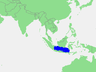
The Java Sea is an extensive shallow sea on the Sunda Shelf, between the Indonesian islands of Borneo to the north, Java to the south, Sumatra to the west, and Sulawesi to the east. Karimata Strait to its northwest links it to the South China Sea. It is a part of the western Pacific Ocean.
This is a list of the extreme points of the United Kingdom: the points that are farther north, south, east or west than any other location. Traditionally the extent of the island of Great Britain has stretched "from Land's End to John o' Groats".

This is a list of the extreme points of Ireland – the points that are furthest north, south, east or west in Ireland. It includes the Republic of Ireland and Northern Ireland.
The Neptune Range is a mountain range, 70 nautical miles long, lying west-southwest of Forrestal Range in the central part of the Pensacola Mountains, Antarctica. The range comprises Washington Escarpment with its associated ridges, valleys and peaks, the Iroquois Plateau, the Schmidt and the Williams Hills.

Shackleton Glacier is a major Antarctic glacier, over 60 nautical miles long and from 5 to 10 nautical miles wide, descending from the Antarctic Plateau from the vicinity of Roberts Massif and flowing north through the Queen Maud Mountains to enter the Ross Ice Shelf between Mount Speed and Waldron Spurs. Discovered by the United States Antarctic Service (USAS) (1939–41) and named by the Advisory Committee on Antarctic Names (US-ACAN) for Sir Ernest Shackleton, British Antarctic explorer.
Northeast Glacier is a steep, heavily crevassed glacier, 13 nautical miles long and 5 nautical miles wide at its mouth, which flows from McLeod Hill westward and then south-westwards into Marguerite Bay between the Debenham Islands and Roman Four Promontory, on the west coast of Graham Land, Antarctica.

Sulzberger Bay is a bay indenting the front of the Sulzberger Ice Shelf between Fisher Island and Vollmer Island, along the coast of Marie Byrd Land, Antarctica.
Lennox-King Glacier is a large valley glacier, about 40 nautical miles (70 km) long that flows east into the Ross Ice Shelf.
Mamiña is a small village located 130 kilometres (81 mi) east from Iquique at 2800 metres (9.340 ft.) above sea level in the foothills of Los Andes Mountain range in northern Chile. Famous for its many hot springs that reach surface at 70 Cº, which are claimed to be beneficial for skin and bones. It has some hotels and hostels and basic services.

Flandres Bay is a large bay lying between Cape Renard and Cape Willems, along the west coast of Graham Land, Antarctica.
Warnes River, a perennial stream of the Macleay River catchment, is located in the Northern Tablelands district of New South Wales, Australia.
Buenos Aires Chico is a village and municipality in Chubut Province in southern Argentina.

Ingeniero Luis A. Huergo is a village and municipality in Río Negro Province in Argentina.
Morris Glacier is a glacier flowing north to the head of Sea Leopard Fjord in the Bay of Isles, South Georgia. it was charted in 1912–13 by American naturalist Robert Cushman Murphy, aboard the brig Daisy, who named it for Edward Lyman Morris, a botanist who was then head of the Department of Natural Science at the Brooklyn Museum.
The Latady Mountains are a group of mountains rising west of Gardner Inlet and between Wetmore Glacier and Ketchum Glacier, in southeastern Palmer Land, Antarctica.
The Lexington Table is a high, flat, snow-covered plateau, about 15 nautical miles long and 10 nautical miles wide, standing just north of Kent Gap and Saratoga Table in the Forrestal Range, Pensacola Mountains, Antarctica.
Schmidt Hills is a group of rock hills, 15 nautical miles long, lying north of Childs Glacier and west of Roderick Valley in the Neptune Range of the Pensacola Mountains, Antarctica.


