Land-use forecasting undertakes to project the distribution and intensity of trip generating activities in the urban area. In practice, land-use models are demand-driven, using as inputs the aggregate information on growth produced by an aggregate economic forecasting activity. Land-use estimates are inputs to the transportation planning process.
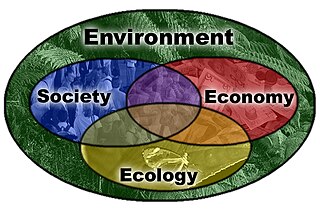
Sustainable urban infrastructure expands on the concept of urban infrastructure by adding the sustainability element with the expectation of improved and more resilient urban development. In the construction and physical and organizational structures that enable cities to function, sustainability also aims to meet the needs of the present generation without compromising the capabilities of the future generations.
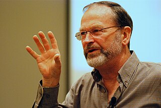
William Rees, FRSC, is Professor Emeritus at the University of British Columbia and former director of the School of Community and Regional Planning (SCARP) at UBC.

Spatial analysis is any of the formal techniques which studies entities using their topological, geometric, or geographic properties. Spatial analysis includes a variety of techniques using different analytic approaches, especially spatial statistics. It may be applied in fields as diverse as astronomy, with its studies of the placement of galaxies in the cosmos, or to chip fabrication engineering, with its use of "place and route" algorithms to build complex wiring structures. In a more restricted sense, spatial analysis is geospatial analysis, the technique applied to structures at the human scale, most notably in the analysis of geographic data. It may also be applied to genomics, as in transcriptomics data.

The modifiable areal unit problem (MAUP) is a source of statistical bias that can significantly impact the results of statistical hypothesis tests. MAUP affects results when point-based measures of spatial phenomena are aggregated into spatial partitions or areal units as in, for example, population density or illness rates. The resulting summary values are influenced by both the shape and scale of the aggregation unit.

Environmental planning is the process of facilitating decision making to carry out land development with the consideration given to the natural environment, social, political, economic and governance factors and provides a holistic framework to achieve sustainable outcomes. A major goal of environmental planning is to create sustainable communities, which aim to conserve and protect undeveloped land.

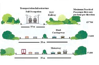
Transportation forecasting is the attempt of estimating the number of vehicles or people that will use a specific transportation facility in the future. For instance, a forecast may estimate the number of vehicles on a planned road or bridge, the ridership on a railway line, the number of passengers visiting an airport, or the number of ships calling on a seaport. Traffic forecasting begins with the collection of data on current traffic. This traffic data is combined with other known data, such as population, employment, trip rates, travel costs, etc., to develop a traffic demand model for the current situation. Feeding it with predicted data for population, employment, etc. results in estimates of future traffic, typically estimated for each segment of the transportation infrastructure in question, e.g., for each roadway segment or railway station. The current technologies facilitate the access to dynamic data, big data, etc., providing the opportunity to develop new algorithms to improve greatly the predictability and accuracy of the current estimations.

An ecosystem model is an abstract, usually mathematical, representation of an ecological system, which is studied to better understand the real system.
A spatial decision support system (SDSS) is an interactive, computer-based system designed to assist in decision making while solving a semi-structured spatial problem. It is designed to assist the spatial planner with guidance in making land use decisions. A system which models decisions could be used to help identify the most effective decision path.
In ecology, urban ecosystems are considered a ecosystem functional group within the intensive land-use biome. They are structurally complex ecosystems with highly heterogeneous and dynamic spatial structure that is created and maintained by humans. They include cities, smaller settlements and industrial areas, that are made up of diverse patch types. Urban ecosystems rely on large subsidies of imported water, nutrients, food and other resources. Compared to other natural and artificial ecosystems human population density is high, and their interaction with the different patch types produces emergent properties and complex feedbacks among ecosystem components.
Shiba Prasad Chatterjee was a Professor of Geography at the University of Calcutta, India. He served as President of the International Geographical Union from 1964 until 1968, Chatterjee received a Murchison Award from the Royal Geographical Society in 1959, and a Padma Bhushan from the Government of India in 1985. He coined the name 'Meghalaya' for one of India's states.
Computational sustainability is an emerging field that attempts to balance societal, economic, and environmental resources for the future well-being of humanity using methods from mathematics, computer science, and information science fields. Sustainability in this context refers to the world's ability to sustain biological, social, and environmental systems in the long term. Using the power of computers to process large quantities of information, decision making algorithms allocate resources based on real-time information. Applications advanced by this field are widespread across various areas. For example, artificial intelligence and machine learning techniques are created to promote long-term biodiversity conservation and species protection. Smart grids implement renewable resources and storage capabilities to control the production and expenditure of energy. Intelligent transportation system technologies can analyze road conditions and relay information to drivers so they can make smarter, more environmentally-beneficial decisions based on real-time traffic information.
Yehua Dennis Wei is a Chinese-American geographer. He is a professor in the Department of Geography and a senior scholar in the Institute of Public and International Affairs at the University of Utah. His research has been funded by the NSF, Lincoln Institute of Land Policy, National Geographic Society, Ford Foundation and Natural Science Foundation of China (NSFC). He has received awards for research excellence from the NSFC, Association of American Geographers' (AAG) China, Asian and Regional Development and Planning Specialty Groups, and University of Wisconsin-Milwaukee.
UrbanSim is an open source urban simulation system designed by Paul Waddell of the University of California, Berkeley and developed with numerous collaborators to support metropolitan land use, transportation, and environmental planning. It has been distributed on the web since 1998, with regular revisions and updates, from www.urbansim.org. Synthicity Inc coordinates the development of UrbanSim and provides professional services to support its application. The development of UrbanSim has been funded by several grants from the National Science Foundation, the U.S. Environmental Protection Agency, the Federal Highway Administration, as well as support from states, metropolitan planning agencies and research councils in Europe and South Africa. Reviews of UrbanSim and comparison to other urban modeling platforms may be found in references.

Traffic simulation or the simulation of transportation systems is the mathematical modeling of transportation systems through the application of computer software to better help plan, design, and operate transportation systems. Simulation of transportation systems started in the 1950s, and is an important area of discipline in traffic engineering and transportation planning today. Various national and local transportation agencies, academic institutions and consulting firms use simulation to aid in their management of transportation networks.

Cambridge Systematics, Inc. is an independent, employee-owned transportation consultancy firm with corporate headquarters located in Medford, Massachusetts. Cambridge Systematics provides strategic planning and management services, objective analysis, and technology applications for passenger, commercial, freight, and transit systems to public and private sectors both nationally and internationally.

Land change models (LCMs) describe, project, and explain changes in and the dynamics of land use and land-cover. LCMs are a means of understanding ways that humans change the Earth's surface in the past, present, and future.
Jianguo "Jingle" Wu (邬建国) is a Dean's Distinguished Professor of Sustainability Science at Arizona State University in Tempe, Arizona. He is also known internationally for his research in landscape ecology and urban ecology. His areas of expertise include landscape ecology, biodiversity, sustainability science, ecosystem functioning and urban ecology. He is the author of over 300 publications, 14 books and has translated 1 book from English to Chinese. He has been awarded multiple awards and honors, including being elected as a Fellow for the American Association for the Advancement of Science (AAAS) in 2007 and an Ecological Society of America fellow in 2019. In 2019 and 2020, Wu was chosen as one of the most influential researchers in the world by Web of Science in the fields of Environment and Ecology (2019) and Cross-Field (2020) due to his collective published works being in the top 1% most cited over the last decade. Since 2005, Jianguo Wu has also served as the editor-in-chief of the international publication Landscape Ecology.

Urban flooding is the inundation of land or property in cities or other built environment, caused by rainfall overwhelming the capacity of drainage systems, such as storm sewers. Urban flooding can happen regardless of whether or not affected communities are located within designated floodplains or near any body of water. It is triggered for example by an overflow of rivers and lakes, flash flooding or snowmelt. During the flood, stormwater or water released from damaged water mains may accumulate on property and in public rights-of-way. It can seep through building walls and floors, or backup into buildings through sewer pipes, cellars, toilets and sinks.
CLUE model is a spatially explicit land-use change model developed to simulate future land-use and land-cover changes, including urban expansion, deforestation, land abandonment, and agricultural intensification. CLUE model is a dynamic modeling framework which simulates land-use change based on quantification of biophysical and human drivers of land-use conversion. The CLUE model can be applied at the national and continental scale, implemented in Central America, Ecuador, China, and Java, Indonesia. CLUE model cannot be employed at regional level. Different versions of CLUE model include CLUE-S, CLUE-Scanner, and Dyna-CLUE models.
B. Deal, 2001. "Ecological Urban Dynamics: The Convergence of Spatial Modeling and Sustainability," The Journal of Building Research and Information 29(5): 381-393.
B. Deal, C. Farello, & B. Hannon, 2004. "A Dynamic Model of the Spread of an Infectious Disease: The Case of Fox Rabies in Illinois," in Landscape Simulation Modeling: A Spatially Explicit, Dynamic Approach R. Costanza and A. Voinov, eds. New York: Springer.
B. Deal and D. Fournier, 2000. "Ecological Urban Dynamics and Spatial Modeling," Proceedings of the American Council for an Energy Efficient Economy, Summer Study on Efficiency and Sustainability, Monterey, CA.
B. Deal and V. Pallathucheril, 2009. "A Use-Driven Approach to Large-Scale Urban Modelling and Planning Support," in Planning Support Systems Best Practice and New Methods S. Geertman and J.C.H. Stillwell, eds. Springer Science+Business, pp. 29–51.
B. Deal and V.G. Pallathucheril, 2009. "Sustainability and Urban Dynamics: Assessing Future Impacts on Ecosystem Services," Sustainability 1: 346-362.
B. Deal and V.G. Pallathucheril, 2007. "Developing and Using Scenarios," in Engaging the Future: Forecasts, Scenarios, Plans, and Projects L.D. Hopkins and M.A. Zapata, eds. Cambridge, MA: Lincoln Institute of Land Policy.
B. Deal and D. Schunk, 2004. "Spatial Dynamic Modeling and Urban Land Use Transformation: A Simulation Approach to Assessing the Costs of Urban Sprawl," The Journal of Ecological Economics 51(1-2): 79-95.
B. Deal and Z. Sun, 2006. "A Spatially Explicit Urban Simulation Model: Landuse Evolution and Impact Assessment Model (LEAM)," in Smart Growth and Climate Change: Regional Development, Infrastructure and Adaptation M. Ruth, ed. Northampton, MA: Edward Elgar, pp. 181–203.
L.D. Hopkins, N. Kaza, & V.G. Pallathucheril, 2005. "A Data Model to Represent Plans and Regulations
Z. Sun, B. Deal, and V.G. Pallathucheril, 2009. "The Land-use Evolution and Impact Assessment Model: A Comprehensive Urban Planning Support System," URISA: Journal of the Urban and Regional Information Systems Association 21(1): 57-68.