Land systems of Western Australia

Last updated

Land systems of Western Australia are systematic land resource concepts where the tying in of geographical, geological, and ecological data is processed to provide land planning and land management systems with sets of information that can process large areas of land in terms of agricultural and other usages.

At times land systems are not referred to directly, but used within terms of land resources and landform resources analysis and appraisal. [1] The government departments from which reports and papers emanate include the Agricultural and Mining departments, as well as Land administration bodies.

In other states and territories of Australia, surveys of the systems have covered a range of subjects related to the issue of management. [5] [6] [7]

Selected land systems

The reports and research use catchment systems, regions and other land management areas as a baseline.

In some cases, land system surveys are captured in map form.

Notes

  1. "Department of Agriculture and Food - Land Resources Series". Archived from the original on 29 March 2015. Retrieved 19 January 2013.
  2. Western Australia; Mitchell, A; Payne, A; Holman, W (1982), An inventory and condition survey of rangelands in the Ashburton River catchment, Western Australia, Dept. of Agriculture, retrieved 19 January 2013
  3. Hall, G. J; Marnham, J. R; Geological Survey of Western Australia (2002), Regolith-landform resources of the Karridale-Tooker and Leeuwin 1:50 000 sheets, Geological Survey of Western Australia, ISBN   978-0-7307-5723-8
  4. Mabbutt, J. A. (Jack Alan); CSIRO. Division of Land Research and Regional Survey (1963), Land systems of the Wiluna-Meekatharra area, Western Australia, Division of Land Research and Regional Survey, CSIRO, retrieved 19 January 2013
  5. Day, K. J; Sivertsen, D. P. (Dominic Paul), (author.); Torlach, D. A, (author.); Conservation Commission of the Northern Territory, (issuing body.) (1985), Land resources of the Sturt Plateau, Northern Territory : a reconnaissance land system survey, Conservation Commission of the NT, retrieved 28 August 2021{{citation}}: |author2= has generic name (help)CS1 maint: multiple names: authors list (link)
  6. Scott, R. M. (Ralph Myles); Speight, J. G. (Johan Garry) (1966), McArthur River land system survey, CSIRO, Division of Land Research, retrieved 28 August 2021
  7. Neagle, Nick; Armstrong D. M. (David M); South Australia. Dept. of Environment and Natural Resources. Science Resource Centre; Santos Limited (2010), A biological survey of the Marqualpie Land System, South Australia, 2008, Science Resource Centre, Client Services Directorate, Dept. of Environment and Natural Resources, ISBN   978-1-921800-10-8
  8. Western Australia. Department of Lands and Surveys (1981), Land systems of the Ashburton catchment [Western Australia], Department of Lands and Surveys, retrieved 28 August 2021
  9. Western Australia. Department of Lands and Surveys; Payne, A. L; Curry, Peter J; Spencer, G. F. (Geoffrey Frank), 1948-; O'Brien, W. J; Western Australia. Department of Agriculture (1980), Land systems of the Carnarvon Basin, Western Australia, Surveyor Generals Division, Dept. of Lands and Surveys, retrieved 28 August 2021{{citation}}: CS1 maint: multiple names: authors list (link)
  10. Payne, A. L; Western Australia. Agriculture Western Australia (1997), An inventory and condition survey of the Sandstone-Yalgoo-Paynes Find area, Western Australia, Dept. of Agriculture, ISBN   978-0-7307-0008-1
  11. Western Australia. Department of Lands and Surveys (1981), Land systems of the Ashburton catchment, Western Australia. SG 50-4 Zone 2., Collier, Dept. of Lands and Surveys, retrieved 28 August 2021
  12. Western Australia. Department of Land Administration; Van Vreeswyk, A. M. E. (Alexandra Margaretha Elizabeth), 1963-; Gilligan, S. A. (Stephen Ambrose), 1952-; Pringle, H. J. Inventory and condition survey of rangelands in the north-eastern goldfields, Western Australia; Pringle, H. J. Pastoral resources and their management in the north-eastern goldfields, Western Australia; Western Australia. Department of Agriculture (1994), "Land systems of the north eastern goldfields rangeland survey : [Western Australia]", Miscellaneous Publication, DOLA, ISSN   0725-847X {{citation}}: CS1 maint: multiple names: authors list (link)

Related Research Articles

Leeuwin-Naturaliste National Park Protected area in Western Australia

Leeuwin-Naturaliste National Park is a national park in the South West region of Western Australia, 267 km (166 mi) south of Perth. It is named after the two locations at either end of the park which have lighthouses, Cape Leeuwin and Cape Naturaliste. It is located in the Augusta-Margaret River and Busselton council areas, and is claimed to have the highest visiting numbers of any national park in Western Australia. The park received 2.33 million visitors through 2008–2009.

Regions of Western Australia Designated regions of Western Australia

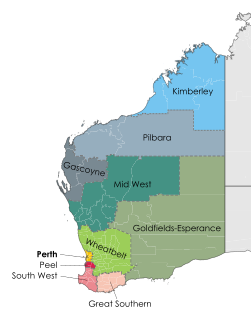
Western Australia (WA) is divided into regions according to a number of systems.

The Mid West region is one of the nine regions of Western Australia. It is a sparsely populated region extending from the west coast of Western Australia, about 200 kilometres (120 mi) north and south of its administrative centre of Geraldton and inland to 450 kilometres (280 mi) east of Wiluna in the Gibson Desert.

Murchison River (Western Australia) River in Western Australia

The Murchison River is the second longest river in Western Australia. It flows for about 820 km (510 mi) from the southern edge of the Robinson Ranges to the Indian Ocean at Kalbarri. The Murchison-Yalgar-Hope river system is the longest river system in Western Australia. It has a mean annual flow of 208 gigalitres, although in 2006, the peak year on record since 1967, flow was 1,806 gigalitres.

A pastoral lease, sometimes called a pastoral run, is an arrangement used in both Australia and New Zealand where government-owned Crown land is leased out to graziers for the purpose of livestock grazing on rangelands.

Yalgoo, Western Australia Town in Western Australia

Yalgoo is a town in the Mid-west region, 499 kilometres (310 mi) north-north-east of Perth, Western Australia and 118 kilometres (73 mi) east-north-east of Mullewa. Yalgoo is in the local government area of the Shire of Yalgoo.

Murchison bioregion Bioregion in Western Australia

The Murchison is an interim Australian bioregion located within the Mid West of Western Australia. The bioregion is loosely related to the catchment area of the Murchison River and has an area of 281,205 square kilometres (108,574 sq mi). Traditionally the region is known as The Murchison.

Yalgoo bioregion Bioregion in Western Australia

Yalgoo is an interim Australian bioregion located in Western Australia. It has an area of 5,087,577 hectares. The bioregion, together with the Avon Wheatbelt and Geraldton Sandplains bioregions, is part of the larger Southwest Australia savanna ecoregion as classified by the World Wildlife Fund.

Pilbara newspapers Newspapers published in the Pilbara region of Western Australia

Pilbara newspapers is a selection of newspapers published in the Pilbara region of Western Australia.

Western Australia has the longest coastline of any state or territory in Australia, at 10,194 km or 12,889 km. It is a significant portion of the coastline of Australia, which is 35,877 km.

The south coast of Western Australia comprises the Western Australian coastline from Cape Leeuwin to Eucla. This is a distance of approximately 1,600 kilometres (1,000 mi), fronting the Great Australian Bight and the Southern Ocean.

The Yalgar River is a 185-kilometre-long tributary of the Murchison River, located in the Shire of Meekatharra in central Western Australia. It rises in the Glengarry Range 25 km southeast of Mooloogool Station homestead, about 80 kilometres northeast of Meekatharra, flowing 145 kilometres westward to a junction with the Hope River. From there it flows north-northwesterly for about 40 kilometres, emptying into the upper reaches of the Murchison River, near Moorarie Station homestead on the Carnarvon-Meekatharra Road.

Gold mining in Western Australia

Gold mining in Western Australia is the third largest commodity sector in Western Australia (WA), behind iron ore and petroleum, with a value of A$11.9 billion.

Boranup, Western Australia Locality in Western Australia

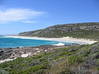
Boranup, in the Shire of Augusta-Margaret River in the South West region of Western Australia, is the site of a large coastal dune blow out known as the "Boranup sand patch" as part of the Boranup beach, and the site of a former M. C. Davies timber company mill. The sand patch area and sand blows affected the alignment of the Busselton to Flinders Bay railway.

Western Australia atlas of mineral deposits and petroleum fields is a multiple-edition summary of mining and petroleum activity in Western Australia in the twenty-first century.

Turquoise Coast is a name attributed to a section of the coastline of Western Australia in the vicinity of Jurien Bay.

Mid West newspapers Newspapers published in the Mid West region of Western Australia

This is a list of newspaper titles published in, or for the Mid West region of Western Australia.