Langer Stall

Last updated
Preserved gate facade of the Langer Stall, 2007 Potsdam Langer Stall Fassade.jpg
Preserved gate facade of the Langer Stall, 2007

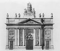
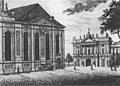
The Lange or Langer Stall (literally Long Stables) was a timber framed riding school and drill hall in Potsdam, built in 1734 under Frederick William I of Prussia. Almost all of it was destroyed in the Second World War, with the only survivor being the gateway facade commissioned by Frederick the Great and designed by Georg Christian Unger.

Contents

Location and dimensions

History and description

Context

Location in a c.1850 city map. Potsdam Langer Stall Lageplan.jpg
Location in a c.1850 city map.
Aerial view of the Garrison Church, with the Lange Stall on the left (1919) Garnisonkirche Luftaufnahme 1919.jpg
Aerial view of the Garrison Church, with the Lange Stall on the left (1919)
Side view of the Lange Stall from the Plantage, from the north-west, in the background of the Garrison Church. Bundesarchiv Bild 170-030, Potsdam, Lange Piele und Langer Stall.jpg
Side view of the Lange Stall from the Plantage, from the north-west, in the background of the Garrison Church.

Riding and drill hall

North facade of the Montierungshauses, design for a 1884 rebuild. Potsdam Montierungshaus.jpg
North facade of the Montierungshauses, design for a 1884 rebuild.

North main building

Southern gate facade

Destruction and partial reconstruction

Langer Stall during the reconstruction - on the left the Plantage seen from the tower of the Garrison Church, 2025 2025-08-24, Blick uber Potsdam von der Garnisonkirche 07.jpg
Langer Stall during the reconstruction - on the left the Plantage seen from the tower of the Garrison Church, 2025

During the bombing of Potsdam on the night of 14-15 April 1945 the Langer Stall caught fire, completely destroying the large timber-framed building. The neighbouring Garrison Church was not hit by the bombs, but was ignited by flying sparks from the Stall and also burned down completely.


Art historical listing

Bibliography (in German)

References

    52°23′45″N13°03′16″E / 52.395781°N 13.054347°E / 52.395781; 13.054347