
Jardinópolis is a municipality in the state of São Paulo, Brazil, in the outskirts of Ribeirão Preto. The population is 41,799 in an area of 502 km². It is 590 m above the sea level. Jardinópolis is known as an important distribution center of mango in Brazil. The town hosts the "Festa do Senhor Bom Jesus da Lapa" religious event, which takes place every year between July 27 and August 6.

Virgem da Lapa is a Brazilian municipality located in the northeast of the state of Minas Gerais. Its population as of 2007 was estimated to be 14,103 people living in a total area of 871 km2 (336 sq mi). The city belongs to the mesoregion of Jequitinhonha and to the microregion of Araçuaí. It became a municipality in 1948.

Lapa is a neighborhood in the city of Rio de Janeiro, in Brazil. It is located in the centre of Rio and is famous for its historical monuments and nightlife.

The Sanctuary of Our Lady of Sameiro or Sanctuary of Sameiro is a sanctuary and Marian shrine located in Espinho, in the surroundings of the city of Braga, Portugal.

Vazante is a municipality in the north of the Brazilian state of Minas Gerais. Its population in 2007 was 19,300 inhabitants in a total area of 1,903 km². It is a large producer of cattle and there is mining of zinc.

Bom Jesus da Lapa is a municipality in Bahia, Brazil located 796 kilometres (495 mi) from the state capital. The population as of 2014 was recorded at 68,922 according to the Brazilian Institute of Geography and Statistics. The city covers a total area of 4,115.5 square kilometres (1,589.0 sq mi) along the banks of the São Francisco River. Its economy is based on agriculture, commerce, tourism and fishing. The current mayor is Eures Ribeiro Pereira. It is the site of the Roman Catholic Diocese of Bom Jesus da Lapa.
Iraquara is a municipality in the state of Bahia in the North-East region of Brazil.

The Sanctuary of Our Lady of Lapa and Residence of the Society of Jesus is a Christian sanctuary in the civil parish of Quintela, municipality of Sernancelhe of northern Portugal. The historical residence of the Society of Jesus, this site was transformed to support pilgrims to the site, and is marked by a chapel delineated by Corinthian columns, supporting plinths surmounted by simple frieze and cornice. The interior was decorated in azulejo tile of polychromatic vegetal design, with triumphal arch dividing the sanctuary from the college, identifiable by the large granite rock in its interior, where legend says the image of the Virgin Mary was first discovered. In this space is the oratory of Senhora das Dores with its nativity by António Ferreira. In the junction between presbytery and sacristy is the double-arched belfry. Also remarkable and unique for this site, and other buildings owned by the Society of Jesus, is the walkway that connects the residences of the complex with the church.
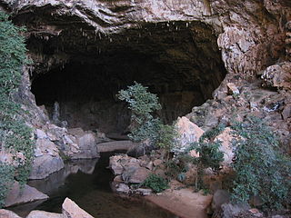
Gruta do Padre (BA-052) is a cave located halfway between the municipalities of Santana, Santa Maria da Vitória e Canápolis, in the state of Bahia, Brazil. It is currently the third-longest cave in the country being 16,400 meters long and unevenness of 125 meters. Discovered in 1914 by a priest who sought honey in hives that get stuck in the rocks, it was often a place of religious pilgrimage where the locals came to pay their promises until the 1950s.
Guy Christian Collet was a French scientist, explorer and spelunker who came to live in Brazil after the World War II. In the karstic region along the Ribeira valley in the State of Sao Paulo he began the exploration for caverns and grottos, becoming later founder and chairman of two speleological societies of deep respectability in the field of speleology in the country. He did work in the areas of underground biology, archeology, nutrition techniques in caves, besides having published several books and reports on the subject.
Lapa Terra Ronca or Caverna Terra Ronca I (GO-063), is a dolomitic limestone cave inside the area of the Terra Ronca State Park, which houses the largest collection of caves and grottoes in the midwest with a number of about 200 being that only Terra Ronca and Angelica are open for the tourists. It is located about 400 kilometers from Brasília, midway between the municipalities of São Domingos, Posse e Guarani de Goiás, in the State of Goiás, Brazil.
Lapa dos Brejões is a complex of caverns formed in Neoproterozoic limestones of the Una Group of caves along the Jacaré river, northeast side of the Irecê sedimentary basin. It is located in the northern portion of the Chapada Diamantina - Polígono das Secas, in the north central part of the State of Bahia, about 500 km from the capital Salvador, Brazil. According to local people, the Lapa dos Brejões was discovered in 1877, but the first discoveries inside the cave were published only in 1938 by Father Camilo Torrendt.
Lapa do Convento (BA-002) is a limestone cave measuring 9300 meters long, located in the municipality of Campo Formoso, in the State of Bahia, Brazil.
Lapa do Salitre, also Lapa do Convento, literally "cave of saltpeter" (BA-0166) is a limestone cave measuring 5,670 meters long, located near the municipality of Campo Formoso, in the State of Bahia, Brazil.

The Monge State Park is a state park in the state of Paraná, Brazil. It is named after a monk, or monks, who was said to have lived in a cave in the park for a while. The cave is now a pilgrimage destination for the monk's devotees.

João Maria D’Agostini, or Giovanni Maria de Agostini, was a lay monk of Italian origin who travelled widely in South and North America preaching and healing with herbal remedies. He drew large crowds who thought he was a holy man and could work miracles, although the authorities often viewed him with suspicion. In Brazil his devotees have conflated his identity with two other monks named João Maria. Thousands people each year visit a cave in the state of Paraná, Brazil, where he once lived.

Sister Joana Angélica de Jesus, registered as Joanna Angelica de Jesus was a Brazilian Conceptionist nun, belonging to the Reformed Order of Our Lady of Conception, and martyr of the Brazilian Independence.

Lapa do Santo is an archaeological site located in the northern part of the Lagoa Santa karst, in the state of Minas Gerais in east-central Brazil. It documents human presence since ca. 12000 years ago presenting three discrete occupation phases that correspond to the early, middle and late Holocene. Llithic technology, zooarchaeology, and multi-isotopic analyses indicate groups of hunter gathers with low mobility and a subsistence strategy focused on gathering plant foods and hunting small and mid-sized mammals. The use of Lapa do Santo as an interment ground started between 10.3-10.6 cal kyBP with primary burials. Between 9.4-9.6 cal kyBP central elements in the treatment of the dead were tooth removal, mutilation, defleshing, exposure to fire and possibly cannibalism, all to reduce the body ahead of reburial of the remains while adhering to strict rules. In the absence of monumental architecture or grave goods, these groups were using parts of fresh corpses to elaborate their rituals. As part of this funerary agenda Lapa do Santo presents the oldest case in the New World of decapitation. Another type of burial included pits filled with separated bones of a single individuals presenting abundant evidence of perimortem fracturing. Lapa do Santo also presents a rare instance of securely dated rock art: an early Holocene low relief anthropomorphic figure depicting a phallus.


