
Larimer County is one of the 64 counties in the U.S. state of Colorado. As of the 2010 census, the population was 299,630. The county seat and most populous city is Fort Collins. The county was named for William Larimer, Jr., the founder of Denver.
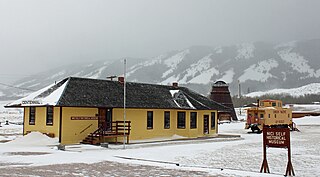
Centennial is a census-designated place (CDP) in Albany County, Wyoming, United States. The population was 270 at the 2010 census.

Laramie is a city in and the county seat of Albany County, Wyoming, United States. The population was 30,816 at the 2010 census. Located on the Laramie River in southeastern Wyoming, the city is west of Cheyenne, at the junction of Interstate 80 and U.S. Route 287.

The Laramie Mountains are a range of moderately high peaks on the eastern edge of the Rocky Mountains in the U.S states of Wyoming and Colorado. The range is the northernmost extension of the line of the ranges along the eastern side of the Rockies, and in particular of the higher peaks of the Front Range directly to the south. North of the range, the gap between the Laramie range and the Bighorn Mountains provided the route for historical trails, such as the Oregon Trail, the Mormon Trail, and the Pony Express.

The Medicine Bow Mountains are a mountain range in the Rocky Mountains that extend for 100-mile (160 km) from northern Colorado into southern Wyoming. The northern extent of this range is the sub-range the Snowy Range. From the northern end of Colorado's Never Summer Mountains, the Medicine Bow mountains extend north from Cameron Pass along the border between Larimer and Jackson counties in Colorado and northward into south central Wyoming. In Wyoming, the range sits west of Laramie, in Albany and Carbon counties to the route of the Union Pacific Railroad and U.S. Interstate 80. The mountains often serve as a symbol for the city of Laramie. The range is home to Snowy Range Ski Area.

The Laramie Plains is an arid highland at an elevation of approx. 8,000 feet (2,400 m) in south central Wyoming in the United States. The plains extend along the upper basin of the Laramie River on the east side of the Medicine Bow Range. The city of Laramie is the largest community in the valley. The plains are separated from the Great Plains to the east by the Laramie Mountains, a spur of the Front Range that extends northward from Larimer County, Colorado west of Cheyenne. The high altitude of the region makes for a cold climate and a relatively short growing season. Unsuitable to most cultivation, the plains have historically been used for livestock raising, primarily of sheep and cattle.

The Fordyce and Princeton Railroad Company is a short-line railroad headquartered in Crossett, Arkansas.
Interstate 80 (I-80) is a part of the Interstate Highway System that runs from San Francisco to Teaneck, New Jersey. In Wyoming, the Interstate Highway runs 402.780 miles (648.212 km) from the Utah state line near Evanston east to the Nebraska state line in Pine Bluffs. I-80 connects Cheyenne, Wyoming's capital and largest city, with several smaller cities along the southern tier of Wyoming, including Evanston, Green River, Rock Springs, Rawlins, and Laramie. The highway also connects those cities with Salt Lake City to the west and Omaha to the east. In Cheyenne, I-80 intersects I-25 and has Wyoming's only auxiliary Interstate, I-180. The Interstate runs concurrently with U.S. Route 30 for most of their courses in Wyoming. I-80 also has shorter concurrencies with US 189 near Evanston, US 191 near Rock Springs, and US 287 and Wyoming Highway 789 near Rawlins. The Interstate has business loops through all six cities along its course as well as a loop serving Fort Bridger and Lyman east of Evanston.

The Ames Monument is a large pyramid in Albany County, Wyoming, designed by Henry Hobson Richardson and dedicated to brothers Oakes Ames and Oliver Ames, Jr., Union Pacific Railroad financiers. The brothers garnered credit for connecting the nation by rail upon completion of the United States' First Transcontinental Railroad in 1869. Oakes, a U.S. representative to the United States Congress from Massachusetts, asserted near total control of its construction, whereas Oliver became president of the Union Pacific Railroad. In 1873 investigators implicated Oakes in fraud associated with financing of the railroad. Congress subsequently censured Oakes, who resigned in 1873. He died soon thereafter.
Wyoming Highway 130 is known locally as the Snowy Range Road. It makes its way west from Laramie across the plains, and rises over the Medicine Bow Mountains. The road then turns north through the town of Saratoga, and ends at Interstate 80. The stretch of road over the mountains is a National Forest Byway. WYO 130 over Snowy Range Pass is closed during winter (November–May)
Union Pacific Railroad Depot or Union Pacific Railroad Complex may refer to:

There is evidence of prehistoric human habitation in the region known today as the U.S. state of Wyoming stretching back roughly 13,000 years. Stone projectile points associated with the Clovis, Folsom and Plano cultures have been discovered throughout Wyoming. Evidence from what is now Yellowstone National Park indicates the presence of vast continental trading networks since around 1000 years ago. The Union Pacific Railroad played a central role in the European settlement of the area. Wyoming became a U.S. territory in 1868 and became the 44th U.S. state in 1890. It was the first state to grant women the right to vote, in 1869.
Wyoming Highway 210 is a Wyoming State Road known as Happy Jack Road that runs from Cheyenne in Laramie County to 10 miles (16 km) east of Laramie at I-80/US 30 in Albany County.
Business routes of Interstate 80 exist in four states; California, Nevada, Utah, and Wyoming.
The Laramie, North Park and Western Railroad was a railroad in the U.S. states of Wyoming and Colorado between Laramie, Wyoming and Coalmont, Colorado. It operated under several different names between 1901 and 1951 prior to absorption by the Union Pacific Railroad.
The Carbon Cut-Off Railway was a railroad line in the U.S. state of Wyoming. In 1889 the Union Pacific Railroad invested $221,000 to construct a rail line from Allen station on the main line to their coal mines near Hanna. In 1892 the railroad operated 17.16 miles (27.62 km) of track between Allen and Hanna and an additional 2.06 miles (3.32 km) of track to the Hanna mine.
The Cheyenne and Northern Railway was a railroad in the U.S. state of Wyoming. The railroad was incorporated in 1886 to build a line from Cheyenne, Wyoming into northern Wyoming and Montana. The line extended 125 miles (201 km) to Wendover on the North Platte River. It was absorbed by Union Pacific Railroad subsidiary Union Pacific, Denver and Gulf Railway and later became part of the Colorado and Southern Railway when the Union Pacific went into receivership.
The Overland Trail was a stagecoach and wagon trail in the American West during the 19th century. While portions of the route had been used by explorers and trappers since the 1820s, the Overland Trail was most heavily used in the 1860s as an alternative route to the Oregon, California, and Mormon trails through central Wyoming. The Overland Trail was famously used by the Overland Stage Company owned by Ben Holladay to run mail and passengers to Salt Lake City, Utah, via stagecoaches in the early 1860s. Starting from Atchison, Kansas, the trail descended into Colorado before looping back up to southern Wyoming and rejoining the Oregon Trail at Fort Bridger. The stage line operated until 1869 when the completion of the First Transcontinental Railroad eliminated the need for mail service via Thais' stagecoach.

Sherman is a ghost town in Albany County, Wyoming, United States. Sherman is 19 miles (31 km) southeast of Laramie in the Laramie Mountains. It is named for William Tecumseh Sherman. The town was located at the summit of the original grade of the First Transcontinental Railroad. Although the railroad has been regraded and relocated through this portion of Wyoming, the name Sherman, or Sherman Summit or Sherman Hill Summit has been applied to the nearby summits of the modern transportation arteries in the Laramie Mountains.
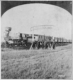
The history of the Union Pacific Railroad stretches from 1862 to the present. For operations of the current railroad, see Union Pacific Railroad; for the holding company that owns the current railroad, see Union Pacific Corporation.


