Jujuy is a province of Argentina, located in the extreme northwest of the country, at the borders with Chile and Bolivia. The only neighboring Argentine province is Salta to the east and south.

Salta is a province of Argentina, located in the northwest of the country. Neighboring provinces are from the east clockwise Formosa, Chaco, Santiago del Estero, Tucumán and Catamarca. It also surrounds Jujuy. To the north it borders Bolivia and Paraguay and to the west lies Chile.
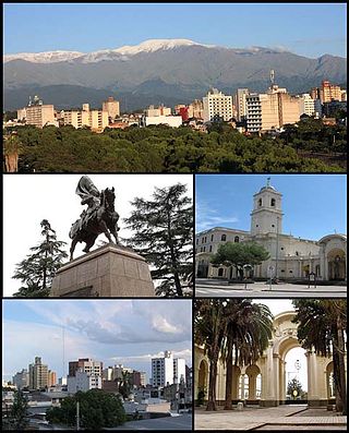
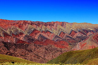
San Salvador de Jujuy, commonly known as Jujuy and locally often referred to as San Salvador, is the capital and largest city of Jujuy Province in northwest Argentina. Also, it is the seat of the Doctor Manuel Belgrano Department. It lies near the southern end of the Humahuaca Canyon where wooded hills meet the lowlands.

What today is commonly referred as the Independence of Argentina was declared on July 9, 1816, by the Congress of Tucumán. In reality, the congressmen who were assembled in Tucumán declared the independence of the United Provinces of South America, which is one of the official names of the Argentine Republic. The Federal League Provinces, at war with the United Provinces, were not allowed into the Congress. At the same time, several provinces from the Upper Peru that would later become part of present-day Bolivia, were represented at the Congress.

The Tren a las Nubes is a tourist train service in Salta Province, Argentina. The service runs along the eastern part of the Salta–Antofagasta railway line of the Belgrano Railway that connects the Argentine Northwest with the border in the Andes mountain range, over 4,220 metres (13,850 ft) above mean sea level, the fifth highest railway in the world. Originally built for economic and social reasons, it is now primarily of interest to tourists as a heritage railway, though cheaper tickets are also available for locals to use the train as transport.
São Sebastião da Amoreira is a municipality in the state of Paraná in the Southern Region of Brazil.

Barrio Bancario is a municipality in Catamarca Province in northwestern Argentina. It is located within the Greater San Fernando del Valle de Catamarca area.
Sumalao is a municipality in Catamarca Province in northwestern Argentina. It is located within the Greater San Fernando del Valle de Catamarca area.
Cobos (Salta) is a village and rural municipality in Salta Province in northwestern Argentina.
La Caldera is a small town and municipality in Salta Province in northwestern Argentina. It is located 25 km north of the city of Salta.

La Viña (Salta) is a village and rural municipality in Salta Province in northwestern Argentina.
Campo Santo (Salta) is a town and municipality in Salta Province in northwestern Argentina.
Coronel Juan Solá is a town and municipality in Salta Province in northwestern Argentina.

Coronel Moldes (Salta) is a town and municipality in Salta Province in northwestern Argentina.
El Bordo is a town and municipality in Salta Province in northwestern Argentina.

The flag of Macha is the name given to a pair of flags of Argentina found at a chapel in the hamlet of Titiri, near the village of Macha, north of Potosí, Bolivia. They are considered to be the first physical flags created by Manuel Belgrano, who in November 1813 hid the standards to prevent them from falling into enemy hands after the United Provinces' army defeat of Ayohuma. They were discovered in 1885. Bolivia kept one of those flags at Sucre; the other was given to Argentina in 1896 and is currently kept at the National Historical Museum. Tucumán Province has used it as provincial flag since 2010. The flag preserved in Argentina is a triband of blue, white and blue bands, like the modern flag of Argentina, but the one kept in Bolivia is a triband of white, blue and white.
Tastil is an archaeological site near Santa Rosa de Tastil, Salta Province, Argentina.

Iruya is a department is located in the north of Salta Province in northwest Argentina in the high altitude basin of the Bermejo River. It is one of 23 administrative units in the province.

Albertogaudrya is an extinct genus of astrapotherian mammal that lived in present-day Patagonia and Salta, Argentina during the Eocene 48.6 to 37.2 million years ago. Fossils of Albertogaudrya have been found in the Lumbrera and Sarmiento Formations. It is named after French palaeontologist Albert Gaudry.