
Verdalsøra is a town in the municipality of Verdal in Trøndelag county, Norway. The town is the administrative center of the municipality. It is located along the Trondheimsfjord at the mouth of the river Verdalselva. The village of Vinne lies 4 kilometres (2.5 mi) to the southeast, Trones lies about 5 kilometres (3.1 mi) to the north, the villages of Forbregd/Lein lie about 4 kilometres (2.5 mi) to the northeast, and the village of Stiklestad lies about 3 kilometres (1.9 mi) to the east. In 1998, the municipal council of Verdal voted to grant the urban area of Verdalsøra town status under the laws of Norway.

Kabelvåg is a village in Vågan Municipality in Nordland county, Norway. It is located on the southern shore of the island of Austvågøya in the Lofoten archipelago. Kabelvåg lies about 5 kilometres (3.1 mi) to the southwest of the town of Svolvær, the administrative centre of Vågan municipality. The 1.13-square-kilometre (280-acre) village has a population (2018) of 1,883 which gives the village a population density of 1,666 inhabitants per square kilometre (4,310/sq mi).

Løding is a village in the municipality of Bodø in Nordland county, Norway. It is located about 17 kilometres (11 mi) east of the town of Bodø, and is connected to the town by the Tverlandet Bridge. The village is mostly referred to as Tverlandet, which also encompasses the areas Hopen, Vatne, Heggmoen, Mjønes, Vågan, Holand, Skålbunes, Elstad, Oddan, Allmenningen, Godøynes (Gaunes), and Naurstad, all of which lies around the village.

Andfiskvatnet is a lake in the municipality of Rana in Nordland county, Norway. The 2.7-square-kilometre (1.0 sq mi) lake lies about 3 kilometres (1.9 mi) southeast of the village of Hauknes and about 6 kilometres (3.7 mi) south of the town of Mo i Rana. The lake flows out into the river Andfiskåga which flows into the Ranfjorden.

Baugevatnet is a lake that lies in Tysfjord Municipality in Nordland county, Norway. The 4.99-square-kilometre (1.93 sq mi) lake is located about 25 kilometres (16 mi) east of the village of Kjøpsvik and just 1.5 kilometres (0.93 mi) northwest of the border with Sweden. The lake Båvrojávrre lies about 3 kilometres (1.9 mi) to the southwest and the lake Langvatnet lies about the same distance to the north.
Faulvatnet (Norwegian) or Låddejávrre (Lule Sami) is a lake that lies in the municipality of Sørfold in Nordland county, Norway. The 7.24-square-kilometre (2.80 sq mi) lake is located about 15 kilometres (9.3 mi) north of the village of Straumen, just west of Rago National Park. The water flows out into the Sleipdalselva river and the water is used for power generation at the Lakshola hydroelectric power station.
Tjårdavatnet or Kjårdavatnet (Norwegian) or Čoađgejávri (Northern Sami) is a lake that is located on the border of Norway and Sweden, about 15 kilometres (9.3 mi) south of the village of Elvegård in Norway. The Norwegian side lies in Narvik Municipality in Nordland county and the Swedish side lies in Gällivare Municipality in Norrbotten County. The lake has an area of about 3.63 square kilometres (1.40 sq mi), with 3.5 square kilometres (1.4 sq mi) being in Norway, the tiny remainder is in Sweden.
Låmivatnet or Loamevatnet (Norwegian) or Loamejávrre (Lule Sami) is a lake in Fauske Municipality in Nordland county, Norway. The 11.43-square-kilometre (4.41 sq mi) lake lies about 5 kilometres (3.1 mi) east of the village of Sulitjelma, just south of the Sulitjelma Glacier and north of Junkerdal National Park. The border with Sweden is 3 kilometres (1.9 mi) east of the lake. The Lomi Hydroelectric Power Station uses the lake as a reservoir.
Markavatnet or Markvatnet is a lake that lies in the municipality of Meløy in Nordland county, Norway. The 2.28-square-kilometre (0.88 sq mi) lake is located about 4 kilometres (2.5 mi) east of the village of Reipå and the same distance north of the municipal centre of Ørnes. The lake Lysvatnet lies about 3 kilometres (1.9 mi) to the east of Markavatnet.

Ramsgjelvatnet is a lake that lies in the municipality of Beiarn in Nordland county, Norway. The lake is located about 5 kilometres (3.1 mi) northeast of the village of Høyforsmoen and about 15 kilometres (9.3 mi) southeast of the village of Moldjord.
Sealggajávri is a lake in Narvik Municipality in Nordland county, Norway. The 4.38-square-kilometre (1.69 sq mi) lake lies just north of the Storsteinfjellet mountain, about 15 kilometres (9.3 mi) southeast of the village of Beisfjord. The ending -jávri is the word for "lake" in the Northern Sami language.
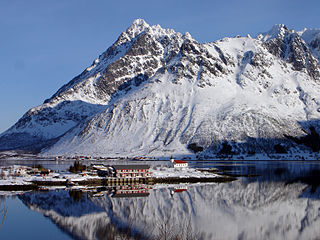
Liland is a village in Vågan Municipality in Nordland county, Norway. It is located on the island of Austvågøya, about 3 kilometres (1.9 mi) south of the village of Laupstad on the eastern bank of the Austnesfjorden. The mountain Higravtindan lies about 3 kilometres (1.9 mi) northeast of Liland.

Skrova is a small island group and village area in Vågan Municipality in Nordland county, Norway. The 2.5-square-kilometre (0.97 sq mi) Skrova island group in the Lofoten archipelago, about 9 kilometres (5.6 mi) southeast of the town of Svolvær. It is located in the Vestfjorden, south of the islands of Austvågøya, Litlmolla, and Stormolla. The largest island in the group is Storskrova and the island of Heimskrova is where most of the population is located. The six main inhabited islands in the group are all interconnected by a small bridge and several man-made causeways.

Austvågøya is the northeasternmost of the larger islands in the Lofoten archipelago in Nordland county, Norway. It is located between the Vestfjorden and the Norwegian Sea. The island of Vestvågøya lies to the southwest and the large island of Hinnøya to the northeast. In 2017, island had about 9,000 residents.
Higravtindan or Higravstindan is the tallest mountain on the island of Austvågøya in the Lofoten archipelago in Nordland county, Norway. It is located on the border of Hadsel Municipality and Vågan Municipality. The village of Laupstad and the European route E10 highway are located about 3 kilometres (1.9 mi) west of the mountain and the village of Liland is located about 3 kilometres (1.9 mi) southwest of the mountain. There is a glacier located on the east side of the mountain.

Henningsvær is a fishing village in Vågan Municipality in Nordland county, Norway. It is located on several small islands off the southern coast of the large island of Austvågøya in the Lofoten archipelago. The village is located about 20 kilometres (12 mi) southwest of the town of Svolvær. Henningsvær is connected to the rest of Vågan via the Henningsvær Bridges. The village is mostly located on the islands of Heimøya and Hellandsøya.
Gravermarka is a small village in Vågan Municipality in Nordland county, Norway. It is located on the western side of the island of Austvågøya in the Lofoten archipelago. The village of Sydalen lies about 1.5 kilometres (0.93 mi) southeast of the village.
Sydalen is a village in the municipality of Vågan in Nordland county, Norway. It is located on the west coast of the island of Austvågøya, about 7 kilometres (4.3 mi) north of the Gimsøystraumen Bridge on the European route E10 highway. The village of Gravermarka lies about 2 kilometres (1.2 mi) north of Sydalen. Strauman Church is located in Sydalen.

Gimsøy is a former municipality in Nordland county, Norway. The 187-square-kilometre (72 sq mi) municipality existed from 1856 until its dissolution in 1964. It was located in the northwestern part of what is now Vågan Municipality. The municipality consisted mainly of the island of Gimsøya as well as the western part of the larger neighboring island of Austvågøya. The municipalities also included 407 other small islands as well has hundreds of little islets and skerries, all of which are located in the Lofoten archipelago. The administrative centre was located at the village of Gimsøysand, where the Gimsøy Church is located.


