Laut Kecil Islands is an archipelago in the south of Borneo. Administratively, the islands belong to South Kalimantan province of Indonesia. The main islands include Matasiri, Kalambau, and Kadapongan.
Laut Kecil Islands is an archipelago in the south of Borneo. Administratively, the islands belong to South Kalimantan province of Indonesia. The main islands include Matasiri, Kalambau, and Kadapongan.

The Antarctic is a polar region around Earth's South Pole, opposite the Arctic region around the North Pole. The Antarctic comprises the continent of Antarctica, the Kerguelen Plateau and other island territories located on the Antarctic Plate or south of the Antarctic Convergence. The Antarctic region includes the ice shelves, waters, and all the island territories in the Southern Ocean situated south of the Antarctic Convergence, a zone approximately 32 to 48 km wide varying in latitude seasonally. The region covers some 20 percent of the Southern Hemisphere, of which 5.5 percent is the surface area of the Antarctica continent itself. All of the land and ice shelves south of 60°S latitude are administered under the Antarctic Treaty System. Biogeographically, the Antarctic realm is one of eight biogeographic realms of Earth's land surface.

Oceania is a geographical region that is described as a continent in some parts of the world. It includes Australasia, Melanesia, Micronesia, and Polynesia. Spanning the Eastern and Western Hemispheres, Oceania is estimated to have a land area of 8,525,989 square kilometres (3,291,903 sq mi) and a population of around 44.4 million as of 2022. While in most of the English-speaking world Oceania is described as a geographical region, outside of the English-speaking world Oceania is described as one of the continents. In this model of the world, Australia is only seen as an island nation contained inside of the continent of Oceania, and not a continent by itself. When compared to the other continents, Oceania is the smallest in land area and the second least populated after Antarctica.
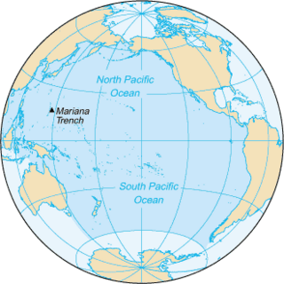
The Pacific Ocean is the largest and deepest of Earth's five oceanic divisions. It extends from the Arctic Ocean in the north to the Southern Ocean in the south, and is bounded by the continents of Asia and Oceania in the west and the Americas in the east.

South America is a continent entirely in the Western Hemisphere and mostly in the Southern Hemisphere, with a relatively small portion in the Northern Hemisphere at the northern tip of the continent. It can also be described as the southern subregion of a single continent called America.

Saint Helena is a British overseas territory located in the South Atlantic Ocean. It is a remote volcanic tropical island 1,950 kilometres west of the coast of south-western Africa, and 4,000 kilometres (2,500 mi) east of Rio de Janeiro in South America. It is one of three constituent parts of the British Overseas Territory of Saint Helena, Ascension and Tristan da Cunha.
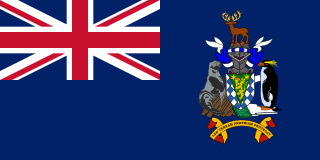
South Georgia and the South Sandwich Islands (SGSSI) is a British Overseas Territory in the southern Atlantic Ocean. It is a remote and inhospitable collection of islands, consisting of South Georgia and a chain of smaller islands known as the South Sandwich Islands. South Georgia is 165 kilometres (103 mi) long and 35 kilometres (22 mi) wide and is by far the largest island in the territory. The South Sandwich Islands lie about 700 kilometres (430 mi) southeast of South Georgia. The territory's total land area is 3,903 km2 (1,507 sq mi). The Falkland Islands are about 1,300 kilometres (810 mi) west from its nearest point.

The North Island, also officially named Te Ika-a-Māui, is one of the two main islands of New Zealand, separated from the larger but much less populous South Island by the Cook Strait. The island's area is 113,729 km2 (43,911 sq mi), making it the world's 14th-largest island. The world's 28th-most-populous island, and the most populous island in Polynesia, the North Island has a population of 3,922,000, accounting for approximately 77% of the total residents of New Zealand.
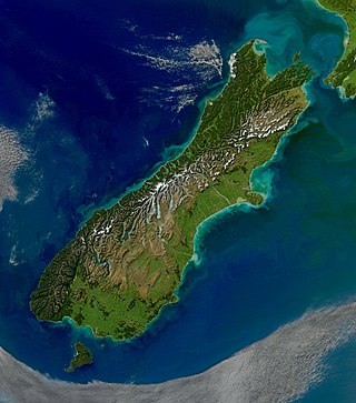
The South Island, also officially named Te Waipounamu, is the larger of the two major islands of New Zealand in surface area, the other being the smaller but more populous North Island. It is bordered to the north by Cook Strait, to the west by the Tasman Sea, and to the south and east by the Pacific Ocean. The South Island covers 150,437 square kilometres (58,084 sq mi), making it the world's 12th-largest island. At low altitude, it has an oceanic climate.

The South China Sea, or South East Asian Sea, is a marginal sea of the Western Pacific Ocean. It is bounded in the north by the shores of South China, in the west by the Indochinese Peninsula, in the east by the islands of Taiwan and northwestern Philippines, and in the south by Borneo, eastern Sumatra and the Bangka Belitung Islands, encompassing an area of around 3,500,000 km2 (1,400,000 sq mi). It communicates with the East China Sea via the Taiwan Strait, the Philippine Sea via the Luzon Strait, the Sulu Sea via the straits around Palawan, the Strait of Malacca via the Singapore Strait, and the Java Sea via the Karimata and Bangka Straits. The Gulf of Thailand and the Gulf of Tonkin are also part of South China Sea. The shallow waters south of the Riau Islands are also known as the Natuna Sea.
This gallery of sovereign state flags shows the national or state flags of sovereign states that appear on the list of sovereign states. For other flags, please see flags of active autonomist and secessionist movements, flags of extinct states and gallery of flags of dependent territories. Each flag is depicted as if the flagpole is positioned on the left of the flag, except for those of the Islamic Emirate of Afghanistan, Iran, Iraq, and Saudi Arabia, which are depicted with the hoist to the right.
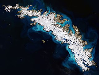
South Georgia is an island in the South Atlantic Ocean that is part of the British Overseas Territory of South Georgia and the South Sandwich Islands. It lies around 1,400 kilometres (870 mi) east of the Falkland Islands. Stretching in the east–west direction, South Georgia is around 170 kilometres (106 mi) long and has a maximum width of 35 kilometres (22 mi). The terrain is mountainous, with the central ridge rising to 2,935 metres (9,629 ft) at Mount Paget. The northern coast is indented with numerous bays and fjords, serving as good harbours.

The South Shetland Islands are a group of Antarctic islands with a total area of 3,687 km2 (1,424 sq mi). They lie about 120 kilometres north of the Antarctic Peninsula, and between 430 and 900 km southwest of the nearest point of the South Orkney Islands. By the Antarctic Treaty of 1959, the islands' sovereignty is neither recognized nor disputed by the signatories and they are free for use by any signatory for non-military purposes.

Asia-Pacific (APAC) is the part of the world near the western Pacific Ocean. The Asia-Pacific region varies in area depending on the context, but it often includes countries in East Asia, Southeast Asia, and Oceania that border the Pacific Ocean. South Asia, Mongolia, Myanmar, and the Russian Far East are generally included in a wider Asia-Pacific region.
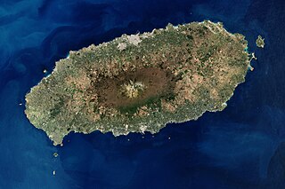
Jeju Island is South Korea's largest island, covering an area of 1,833.2 km2 (707.8 sq mi), which is 1.83 percent of the total area of the country. It is also the most populous island in South Korea; at the end of September 2020, the total resident registration population of Jeju Province is 672,948, of which 4,000 reside on outlying islands such as the Chuja Islands and Udo Island. The total area of the Jeju Special Self-Governing Province is 1,849 km2 (714 sq mi).

The states and territories are federated administrative divisions in Australia, ruled by regional governments that constitute the second level of governance between the federal government and local governments. States are self-governing polities with incomplete sovereignty and have their own constitutions, legislatures, departments, and certain civil authorities that administer and deliver most public policies and programs. Territories can be autonomous and administer local policies and programs much like the states in practice, but are still constitutionally and financially subordinate to the federal government and thus have no true sovereignty.

The West Indies is a subregion of North America, surrounded by the North Atlantic Ocean and the Caribbean Sea, which comprises 13 independent island countries, 18 dependencies, and three archipelagos: the Greater Antilles, the Lesser Antilles, and the Lucayan Archipelago.

The Falkland Islands is an archipelago in the South Atlantic Ocean on the Patagonian Shelf. The principal islands are about 300 mi (480 km) east of South America's southern Patagonian coast and about 752 mi (1,210 km) from Cape Dubouzet at the northern tip of the Antarctic Peninsula, at a latitude of about 52°S. The archipelago, with an area of 4,700 sq mi (12,000 km2), comprises East Falkland, West Falkland, and 776 smaller islands. As a British overseas territory, the Falklands have internal self-governance, but the United Kingdom takes responsibility for their defence and foreign affairs. The capital and largest settlement is Stanley on East Falkland.
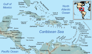
The Caribbean is a region of the Americas that consists of the Caribbean Sea, its islands and the surrounding coasts. The region is southeast of the Gulf of Mexico and the North American mainland, east of Central America, and north of South America.
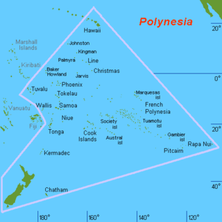
Polynesia is a subregion of Oceania, made up of more than 1,000 islands scattered over the central and southern Pacific Ocean. The indigenous people who inhabit the islands of Polynesia are called Polynesians. They have many things in common, including language relatedness, cultural practices, and traditional beliefs. In centuries past, they had a strong shared tradition of sailing and using stars to navigate at night. The largest country in Polynesia is New Zealand.