The Arctic Archipelago, also known as the Canadian Arctic Archipelago, is an archipelago lying to the north of the Canadian continental mainland, excluding Greenland and Iceland

USS Bogue (AVG/ACV/CVE/CVHE-9) was the lead ship in the Bogue class of escort carriers in the United States Navy during World War II. The ship was named for Bogue Sound in North Carolina.
This is a list of the extreme points of the United Kingdom: the points that are farther north, south, east or west than any other location. Traditionally the extent of the island of Great Britain has stretched "from Land's End to John o' Groats".
The Ohio Range is a range in the Transantarctic Mountains of Antarctica. It is about 30 nautical miles long and 10 nautical miles wide, extending west-southwest – east-northeast from Eldridge Peak to Mirsky Ledge. The range forms the northeast end of the Horlick Mountains and consists primarily of a large snow-topped plateau with steep northern cliffs and several flat-topped ridges and mountains. The highest point, 2,990 metres (9,810 ft), is the summit of Mount Schopf.

Shackleton Glacier is a major Antarctic glacier, over 60 nautical miles long and from 5 to 10 nautical miles wide, descending from the Antarctic Plateau from the vicinity of Roberts Massif and flowing north through the Queen Maud Mountains to enter the Ross Ice Shelf between Mount Speed and Waldron Spurs. Discovered by the United States Antarctic Service (USAS) (1939–41) and named by the Advisory Committee on Antarctic Names (US-ACAN) for Sir Ernest Shackleton, British Antarctic explorer.
The Bermel Peninsula is a rugged, mountainous peninsula, approximately 15 nautical miles long and 7 nautical miles ) wide, between Solberg Inlet and Mobiloil Inlet on the Bowman Coast, Graham Land, Antarctica. The feature rises to 1,670 metres (5,480 ft) in Bowditch Crests and includes Yule Peak, Mount Wilson, Campbell Crest, Vesconte Point, Wilson Pass, Rock Pile Peaks, Miyoda Cliff, and Rock Pile Point.

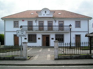
Boqueixón is a municipality in the province of A Coruña, in the autonomous community of Galicia in northwestern Spain. It has a population of 4,445 inhabitants.

Ventosa de la Cuesta is a municipality located in the province of Valladolid, Castile and León, Spain. According to the 2004 census (INE), the municipality has a population of 135 inhabitants.

Palmópolis is a municipality in the northeast of the Brazilian state of Minas Gerais. Its population in 2020 was 5,349 inhabitants in a total area of 436 km².

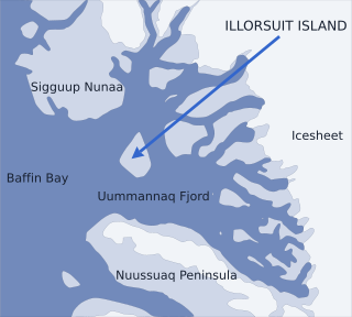
Nunavik Peninsula is a large peninsula in northwestern Greenland. It separates two cultural and geographical regions of northwestern Greenland: Uummannaq Fjord region in the southeast, and Upernavik Archipelago in the north.
Ramblones is a village and municipality in Catamarca Province in northwestern Argentina.
Singuil is a village and municipality in Catamarca Province in northwestern Argentina.
The Butler Glacier is a broad glacier draining the north side of Edward VII Peninsula in the vicinity of Clark Peak, and flowing generally northeastward through the Alexandra Mountains to its terminus in Sulzberger Bay.
The Gutenko Mountains are a large, scattered group of hills, nunataks and small mountains at the south end of Dyer Plateau in central Palmer Land, Antarctica. The feature includes the Elliott Hills, the Rathbone Hills, the Guthridge Nunataks and the Blanchard Nunataks.
Pollard Glacier is a glacier flowing into the south side of Comrie Glacier to the east of Bradford Glacier, on the west coast of Graham Land. Mapped by the Falkland Islands Dependencies Survey (FIDS) from photos taken by Hunting Aerosurveys Ltd. in 1956–57. Named by the United Kingdom Antarctic Place-Names Committee (UK-APC) for Alan F.C. Pollard (1877–1948), English documentalist, founder and first president of the British Society for International Bibliography, and pioneer in the introduction of the Universal Decimal Classification into British libraries.
Mission Rock is a low-lying rock lying southwest of the Guébriant Islands, off the south end of Adelaide Island, Antarctica. It was surveyed by the Royal Navy Hydrographic Survey Unit, 1962–63, and was so named by the UK Antarctic Place-Names Committee in 1963 because of the rock's proximity to the Guébriant Islands, which were named for the French missionary Father Jean Budes de Guébriant.
Hull Bay is an ice-filled bay, about 25 nautical miles wide, fed by Hull Glacier, which descends into it between Lynch Point and Cape Burks, on the coast of Marie Byrd Land, Antarctica.
Tailend Nunatak is a nunatak, 535 m, at the north end of the Theron Mountains. It was first mapped in 1956-57 by the Commonwealth Trans-Antarctic Expedition and is so named because it was the last rock feature at the northeast end of the Theron Mountains seen either from the ground or from the air by members of the Commonwealth Trans-Antarctic Expedition during their survey in 1956–57.


