Related Research Articles
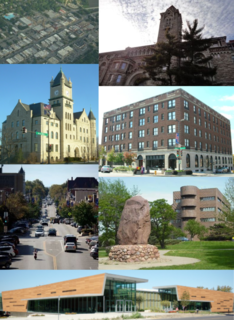
Lawrence is the county seat of Douglas County, Kansas, United States, and the sixth-largest city in the state. It is in the northeastern sector of the state, astride Interstate 70, between the Kansas and Wakarusa Rivers. As of the 2020 census, the population of the city was 94,934. Lawrence is a college town and the home to both the University of Kansas and Haskell Indian Nations University.

Shawnee is a city in Johnson County, Kansas, United States and is part of the Kansas City metropolitan area. As of the 2020 census, the population of the city was 67,311.

Quantrill's Raiders were the best-known of the pro-Confederate partisan guerrillas who fought in the American Civil War. Their leader was William Quantrill and they included Jesse James and his brother Frank.
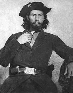
William Clarke Quantrill was a Confederate guerrilla leader during the American Civil War.

The Lawrence Massacre, also known as Quantrill's raid, was an attack during the American Civil War (1861–65) by Quantrill's Raiders, a Confederate guerrilla group led by William Quantrill, on the Unionist town of Lawrence, Kansas, killing around 150 unarmed men and boys.
William T. Anderson, known by the nickname "Bloody Bill" Anderson, was an American soldier who was one of the deadliest and most notorious Confederate guerrilla leaders in the American Civil War. Anderson led a band of volunteer partisan raiders who targeted Union loyalists and federal soldiers in the states of Missouri and Kansas.

Jayhawkers and red legs are terms that came to prominence in Kansas Territory, during the Bleeding Kansas period of the 1850s; they were adopted by militant bands affiliated with the free-state cause during the American Civil War. These gangs were guerrillas who often clashed with pro-slavery groups from Missouri, known at the time in Kansas Territory as "Border Ruffians" or "Bushwhackers". After the Civil War, the word "Jayhawker" became synonymous with the people of Kansas, or anybody born in Kansas. Today a modified version of the term, Jayhawk, is used as a nickname for a native-born Kansan, but more typically for a student, fan, or alumnus of the University of Kansas.
Fort Baxter, also known as Fort Blair, was a small US Army post located in the southeast corner of Kansas near present-day Baxter Springs. This area was known as the Cherokee Strip. It was one of a few Kansas forts attacked by Confederate forces during the American Civil War. At one point the Confederate government claimed authority over the Neutral Lands. Both Union and Confederate troops operated in the area, as did guerrilla forces and militias prevalent in the Kansas-Missouri border area.
Louis Carpenter was a Judge in Douglas County, Kansas and was the highest ranking civic member of the town of Lawrence to be murdered by Quantrill's raiders during the Lawrence Massacre.
Kansas has always been home to many forts and military posts.
On March 7, 1862, Confederate guerrillas under William C. Quantrill raided the small Kansas community of Aubry, southwest of Kansas City, Missouri, and just west of the Kansas-Missouri border. Three residents were killed in the raid and much property was carted away by the guerrillas.
In early May 1863 a temporary camp, Camp Hooker, was established at the site of what later became Baxter Springs, Kansas. This area was located in what was known as the Cherokee Strip (Kansas). In late May while the camp commander, Col. James M. Williams, was in Fort Scott, the troops moved the camp three blocks to the east to what is now Washington School Hill. The new camp, Camp Ben Butler (named after Maj. Gen. Benjamin Butler, was in a highly defendable position. It occupied a plateau that covered more than two square blocks. Only a small area to the south allowed easy access to camp. In fact, much of the surrounding area was practically impenetrable by men or horses.
Lawrence, Kansas was not well defended in the early part of the Civil War. That ended with William Quantrill's devastating guerrilla raid August 21, 1863. By early 1864 Union soldiers were permanently camped on the top and slopes of Mount Oread, then to Lawrence's southwest. It seems the camp was originally named Camp Ewing, after Brig. Gen. Thomas Ewing.
During the Civil War, Coldwater Grove existed 13½ miles east of Paola, Kansas, in Miami County. It straddled the Kansas-Missouri border, being partly in both states. About June 1863 a Union military post was established on the Kansas side of the community and the post was put under the command of Lt. Col. Charles S. Clark. Clark also commanded four nearby posts.
Eggert House is located 1½ miles west of the abandoned Franklin townsite in Douglas County, Kansas. Franklin was east of Lawrence, Kansas. Originally the house was a log hut that the Johan H. Eggert family moved into in 1856. At the time pro-southern partisans raided the area, taking items from area settlers, including the Eggert family.
Fort Lane, on the crest of Mount Oread, then southwest of Lawrence, Kansas, was built by the residents of Lawrence in 1856 to serve as a lookout post to observe groups of men desiring to attack Lawrence. Lawrence was a free-state community built by northerners. From 1854 to 1861, when Kansas became a state, at times the area around Lawrence was a battleground for settlers who had come from both the northern and southern states. From this location, one could see for many miles in all directions.
The Lawrence blockhouses were a series of blockhouses built in the spring of 1864 in Lawrence, Kansas, to provide defensive structures in case of attack by Confederate guerrillas. On August 21, 1863, Lawrence had been attacked by 400 guerrillas and Confederate Army recruits under the command of William C. Quantrill. Lawrence was caught virtually defenseless and much of the town was destroyed and about 180 men and boys were killed, most of them defenseless. A militia became active by spring 1864 to prevent another attack.
Paola's post, sometimes called Post Paola, in Miami County, Kansas, was located on the west side of Bull Creek, just west of Paola, Kansas. It was probably established in December 1861, as that was the first time it was mentioned. This post became one of the more important posts along the Kansas-Missouri border during the Civil War. It became a district headquarters in 1863. Later, in September 1864, it was designated a subdistrict headquarters, when the district headquarters was moved to Lawrence, Kansas. The military road from Fort Leavenworth to Fort Gibson ran through Paola, thus ensuring the post always had some importance.
Franklin is a ghost town in Douglas County, Kansas, United States. Established as a proslavery stronghold, the town played a key role in the "Bleeding Kansas" conflict that troubled the territory in the 1850s.

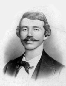
Oscar Eugene Learnard was a campaigner for Free State Kansas, a Republican organizer, a colonel in the Union Army during the American Civil War, a railroad official, a two-term Kansas State Senator, and a school administrator.
References
- ↑ William E. Connelley, Quantrill and the Border Wars (Cedar Rapids, Iowa: The Torch Press, 1910), pp. 330, 340.
- ↑ Peter D. Ridenour, Quantrill's Raid: Aug. 21, 1863 (Lawrence, Kans.: Douglas County Historical Society, n.d.), p. 1.
- ↑ Connelley, pp. 337-40, 376-7, 388.
- ↑ Richard Cordley, The Lawrence Massacre by a Band of Missouri Ruffians Under Quantrell (Lawrence, Kans.: J. S. Broughton, 1865), in the Kansas Collection, at http://www.kancoll.org/books/cordley_massacre/quantrel.raid.html .
- ↑ Ridenour, pp. 14-5.