Isère is a landlocked department in the southeastern French region of Auvergne-Rhône-Alpes. Named after the river Isère, it had a population of 1,271,166 in 2019. Its prefecture is Grenoble. It borders Rhône to the northwest, Ain to the north, Savoie to the east, Hautes-Alpes to the south, Drôme and Ardèche to the southwest and Loire to the west.

Annecy is the prefecture and largest town of the Haute-Savoie department in the Auvergne-Rhône-Alpes region of Southeastern France. It lies on the northern tip of Lake Annecy, 35 kilometres (22 mi) south of Geneva, Switzerland. Nicknamed the "Pearl of the French Alps" in Raoul Blanchard's monograph describing its location between lake and mountains, the town controls the northern entrance to the lake gorge. Due to a lack of available building land between the lake and the protected Semnoz mountain, its population has remained stable, around 50,000 inhabitants, since 1950. However, the 2017 merger with several ex-communes extended the population of the city to 128,199 inhabitants and that of the urban area to 177,622, placing Annecy seventh in the Auvergne-Rhône-Alpes region.

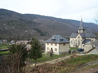
Saint-Pierre-de-Chartreuse is a commune in the Isère department in the Auvergne-Rhône-Alpes region in southeastern France.

Autrans is a former commune in the Isère department in the Rhône-Alpes region of south-eastern France. On 1 January 2016, it was merged into the new commune of Autrans-Méaudre-en-Vercors.

Corbel is a commune in the Savoie department in the Auvergne-Rhône-Alpes region in south-eastern France. It borders the department of Isère.

Saint-Pierre-d'Entremont is a commune in the Savoie department in the Auvergne-Rhône-Alpes region in south-eastern France.
Saint-Jean-de-Couz is a commune in the Savoie department in the Auvergne-Rhône-Alpes region in south-eastern France.

Le Reposoir is a commune in the Haute-Savoie department in the Auvergne-Rhône-Alpes region in south-eastern France.

Entremont-le-Vieux is a commune in the Savoie department in the Auvergne-Rhône-Alpes region in Southeastern France. In 2019, it had a population of 644.
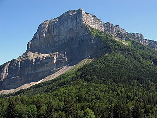
Mont Granier (1,933m) is a limestone mountain located between the départements of Savoie and Isère in France. It lies in the Chartreuse Mountains range of the French Prealps between the towns of Chapareillan and Entremont-le-Vieux. Its east face overlooks the valley of Grésivaudan and Combe de Savoie, and the north face overlooks Chambéry. At 900 meters tall, Mont Granier has one of the highest cliffs in France.

Mont Joigny is a mountain in the Chartreuse Mountains in Savoie, France. It lies west of the Col du Granier and north of Entremont-le-Vieux.

Col du Granier is a mountain pass in the Alps in the department of Savoie in France which crosses the Chartreuse Mountains to connect the villages of Entremont-le-Vieux (south), Apremont (north) and Chapareillan (east). It has been traversed several times by the Tour de France cycle race, including on Stage 12 of the 2012 race. It is situated between Mont Granier (south-east) and Mont Joigny (north-west).

La Cochette is a mountain of the Chartreuse Mountains culminating at 1618 m above sea level and located at the edge of Corbel, of Saint-Jean-de-Couz and of Entremont-le-Vieux in Savoie.

The Col du Grapillon is a mountain pass located 1,509 metres (4,951 ft) above sea level in the Chartreuse Mountains between La Cochette to the south, and Mont Outheran to the north
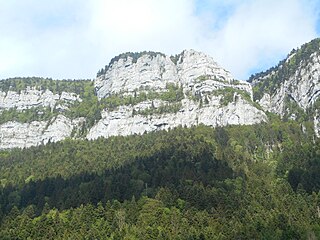
The Roc de Gleisin is a Massif de la Chartreuse mountain located between Entremont-le-Vieux and Saint-Pierre-d'Entremont in Savoie districts. Rock bars on its western side also delimit the territory of Corbel district. The summit is 1,434 metres (4,705 ft) above sea level. The mountain is most composed of limestone.

The Col de la Cluse is a mountain pass located 1,169 m above sea level in the Chartreuse Mountains. It connects Le Désert d'Entremont to Corbel, Savoie, France. The main road of the pass is the D45.

The Sommet du Pinet is a Chartreuse mountain situated at the south of the mont Granier, culminating at 1,867 m above sea level.
The Col du Mollard is a mountain pass located between the councils of Entremont-le-Vieux and Saint-Thibaud-de-Couz in the Chartreuse Mountains and culminating at 1,320 meters above sea level.
Communauté de communes Cœur de Chartreuse is a French intercommunality composed of 17 communes, situated in the departments of Isère and Savoie in the Auvergne-Rhône-Alpes region. It was founded on January 1, 2014. It seat is Entre-deux-Guiers. Its area is 356.8 km2, and its population was 17,052 in 2019.
The Réserve naturelle nationale des Hauts de Chartreuse (RNN136) is a national nature reserve located in Rhône-Alpes in the Chartreuse mountains. Classified in 1997, it covers 4,450 hectares and forms a vast rocky tray bordered by cliffs which has mountain and subalpine environments.