Related Research Articles

The Little Kanawha River is a tributary of the Ohio River, 169 mi (269 km) long, in western West Virginia in the United States. Via the Ohio, it is part of the watershed of the Mississippi River, draining an area of 2,320 mi2 (6,009 km2) on the unglaciated portion of the Allegheny Plateau. It served as an important commercial water route in the early history of West Virginia, particularly in the logging and petroleum industries.
New Creek is an 18.4-mile-long (29.6 km) stream in eastern West Virginia, United States. It is the third major West Virginia tributary to the North Branch Potomac River. Via the Potomac, it is part of the watershed of Chesapeake Bay.
Back Creek is a 59.5-mile-long (95.8 km) tributary of the Potomac River that flows north from Frederick County, Virginia, to Berkeley County in West Virginia's Eastern Panhandle. Back Creek originates along Frederick County's border with Hampshire County, West Virginia, at Farmer's Gap in the Great North Mountain. Its name reflects its location to the west of North Mountain. The perspective of colonists from the east in the 18th century led them to call it "Back Creek", because it lay to the back of North Mountain.
Tearcoat Creek is an 18.3-mile-long (29.5 km) free-flowing tributary stream of the North River, itself a tributary of the Cacapon River, making it a part of the Potomac River and Chesapeake Bay watersheds. The creek is located in central Hampshire County, West Virginia. Its name is believed to have been derived from the tearing of the coats of British soldiers by low-hanging branches as they forded the stream during either the French and Indian or the American Revolutionary Wars.

Cherry Run is a 7.2-mile-long (11.6 km) meandering stream that forms the northern section of the boundary between Morgan and Berkeley counties in West Virginia's Eastern Panhandle. While it is mostly non-navigable, Cherry Run provides many pools of varying depths for fishing and swimming. As a tributary of the Potomac River, Cherry Run is part of the Potomac and Chesapeake Bay watersheds.
Mill Creek is a 14.5-mile-long (23.3 km) tributary of Opequon Creek, belonging to the Potomac River and Chesapeake Bay watersheds, located in Berkeley County in West Virginia's Eastern Panhandle. Its name reflects its past as a popular site for various types of mills, beginning with one constructed by Morgan Morgan in the mid-18th century near his cabin in present-day Bunker Hill.

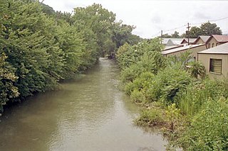
Tuscarora Creek in Berkeley County, West Virginia, is an 11.4-mile-long (18.3 km) tributary of Opequon Creek, which drains into the Potomac River in the Chesapeake Bay watershed.
Lost Creek can refer to several places:
Dans Run is a 2.3-mile-long (3.7 km) non-navigable tributary stream of the North Branch Potomac River in Mineral County, West Virginia. Dans Run rises to the east of Patterson Creek Mountain and empties into the North Branch at the community of Dans Run on the old Baltimore and Ohio Railroad. Dans Run Island in the North Branch Potomac, at its confluence with Dans Run, is also named for the small stream.

The Dry Fork is a 47.7-mile-long (76.8 km) tributary of the Tug Fork, belonging to the Ohio River watershed. The river is located in McDowell County, West Virginia, and Tazewell County, Virginia, in the United States. The mouth of the Dry Fork into the Tug Fork is located at Iaeger.
Fourpole Creek is a 4.8-mile-long (7.7 km) tributary of the Tug Fork, belonging to the Ohio River and Mississippi River watersheds. It is located in McDowell and Mingo counties in the U.S. state of West Virginia. Fourpole Creek forms the boundary between McDowell and Mingo counties.
Buffalo Creek is a 4.1-mile-long (6.6 km) free-flowing tributary stream of the South Branch Potomac River, itself a tributary of the Potomac River, making it a part of the Chesapeake Bay watershed. Buffalo Creek is located in west-central Hampshire County in the U.S. state of West Virginia. Because the stream flows through several small farms, Buffalo Creek primarily serves agriculture purposes with segments used for livestock watering.
Patterson Creek is a 51.2-mile-long (82.4 km) tributary of the North Branch Potomac River in West Virginia's Eastern Panhandle, in the United States. It enters the North Branch east of Cumberland, Maryland, with its headwaters located in Grant County, West Virginia. Patterson Creek is the watershed for two-thirds of Mineral County, West Virginia. The creek passes through Lahmansville, Forman, Medley, Williamsport, Burlington, Headsville, Reeses Mill, Champwood, and Fort Ashby.
Indian Creek is a stream located entirely within Ritchie County, West Virginia. It is a tributary of Hughes River.
First Creek is a stream in the U.S. state of West Virginia. It is a tributary of the Pocatalico River.
Second Creek is a stream in Kanawha County, West Virginia. It is a tributary of the Pocatalico River.
Pinch Creek is a stream in the U.S. state of West Virginia. It is a tributary of the Elk River.
Rich Creek is a stream in the U.S. state of West Virginia. It is a tributary of the Bluestone River.
Sharps Run is a stream in the U.S. state of West Virginia. It is a tributary of Cow Creek.
Brazil Creek is a stream in Crawford and Washington counties in the U.S. state of Missouri. It is a tributary to the Meramec River.
References
- ↑ U.S. Geological Survey Geographic Names Information System: Lee Creek (Ohio River tributary)
- ↑ Kenny, Hamill (1945). West Virginia Place Names: Their Origin and Meaning, Including the Nomenclature of the Streams and Mountains. Piedmont, WV: The Place Name Press. p. 366.
39°08′59″N81°44′26″W / 39.14972°N 81.74056°W