This article does not cite any sources .(June 2021) (Learn how and when to remove this template message) |
Legat is a small town in southern Mauritania near the Senegal River.
This article does not cite any sources .(June 2021) (Learn how and when to remove this template message) |
Legat is a small town in southern Mauritania near the Senegal River.
It is a station on a proposed railway to carry phosphate from mines near Kaedi.

Mahanoy Township is a township in Schuylkill County, Pennsylvania, United States. The population was 1,112 at the 2000 census.
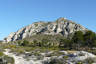
The Chaîne des Alpilles is a small range of low mountains in Provence, southern France, located about 20 km (12 mi) south of Avignon.
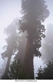
Sequoia National Forest is located in the southern Sierra Nevada mountains of California. The U.S. National Forest is named for the majestic Giant Sequoia trees which populate 38 distinct groves within the boundaries of the forest.

San José del Potrero is a municipality in the Honduran department of Comayagua.
Cabañas is a municipality in the Honduran department of Copán.
Dulce Nombre is a municipality in the Honduran department of Copán.
El Porvenir is a municipality in the Honduran department of Francisco Morazán.

Egüés is a municipality of Navarre, Spain, in the metropolitan area of Pamplona. Its population is 19,014.
Villafranca is a town and municipality located in the province and the autonomous community of Navarre, northern Spain.

Néma is a town in southeastern Mauritania, close to the border with Mali. It is located at around 16°37′0″N7°15′0″W at the eastern end of the Aoukar. It is the capital of Hodh Ech Chargui Region and of the Néma Department.
The Lower Similkameen Indian Band or Lower Smelqmix, is a First Nations band government in the Canadian province of British Columbia. Their office is located in the village of Keremeos in the Similkameen region. They are a member of the Okanagan Nation Alliance.
Strand Fiord Pass is a mountain pass on southern Axel Heiberg Island, Nunavut, Canada.

Stróże is a village in the administrative district of Gmina Zakliczyn, within Tarnów County, Lesser Poland Voivodeship, in southern Poland. It lies approximately 6 kilometres (4 mi) west of Zakliczyn, 29 km (18 mi) south-west of Tarnów, and 64 km (40 mi) south-east of the regional capital Kraków.
Aere Mbar is a town and commune in the Brakna Region of south-western Mauritania. It is located near the border with Senegal.

Fimbulheimen is a mountain range in Queen Maud Land, Antarctica. It stretches from Jutulstraumen by 1° west of Carsten Borchgrevink Ice at 18° east, about 200 km from the ice edge. Fimbulheimen is thus between Maudheim Plateau and Sør-Rondane.

The Henderson molybdenum mine is a large underground molybdenum mine west of the town of Empire in Clear Creek County, Colorado, USA. The Henderson mine, which has produced molybdenum since 1976, is owned by Freeport-McMoRan.
Kitselas First Nation is the band government of the Kitselas subgroup of the Tsimshian. The band government is based at Gitaus in the Skeena Valley in the Skeena River valley to the northeast of the city of Terrace, British Columbia, Canada. Though there is no Tsimshian tribal council, they are a participant in the Tsimshian First Nations treaty council.
The Liard Plain is a landform in far northern British Columbia, Canada. It is located between the Smith River and the Dease Plateau.

HMS Viscount was a V-class destroyer of the British Royal Navy that saw service in the final months of World War I and in World War II.
Pilot Knob Station, a former stage station of the Butterfeild Overland Mail, located near Andrade, California. It was placed 10 miles west of the Fort Yuma stage station on the road along the Colorado River, in California, and 18 miles east of the Cooke's Wells Station in Baja California. It was subsequently used by the Union Army as station for its troops and supply wagons during the American Civil War and was a stage station again after the Civil War until the Southern Pacific Railroad, arrived in Yuma, Arizona ending the need for the stage line from California.
Coordinates: 16°45′0″N14°50′0″W / 16.75000°N 14.83333°W
| | This Mauritania location article is a stub. You can help Wikipedia by expanding it. |