The High German languages or High German dialects comprise the varieties of German spoken south of the Benrath and Uerdingen isoglosses in central and southern Germany, Austria, Liechtenstein, Switzerland, and Luxembourg, as well as in neighboring portions of France, Italy, the Czech Republic (Bohemia), and Poland. They are also spoken in diaspora in Romania, Russia, the United States, Brazil, Argentina, Mexico, Chile, and Namibia.

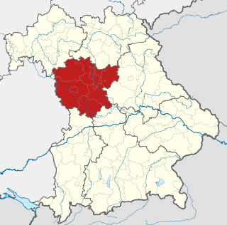
Upper Franconia is a Regierungsbezirk of the state of Bavaria, southern Germany. It forms part of the historically significant region of Franconia, all now part of the German Federal State of Bayern (Bavaria).
Middle Franconia is one of the three administrative regions of Franconia in Bavaria, Germany. It is located in the west of Bavaria and borders the state of Baden-Württemberg. The administrative seat is Ansbach, however the most populous city is Nuremberg.

The Duchy of Bavaria was a frontier region in the southeastern part of the Merovingian kingdom from the sixth through the eighth century. It was settled by Bavarian tribes and ruled by dukes (duces) under Frankish overlordship. A new duchy was created from this area during the decline of the Carolingian Empire in the late ninth century. It became one of the stem duchies of the East Frankish realm which evolved as the Kingdom of Germany and the Holy Roman Empire.

East Franconian, usually referred to as Franconian in German, is a dialect which is spoken in Franconia, the northern part of the federal state of Bavaria and other areas in Germany around Nuremberg, Bamberg, Coburg, Würzburg, Hof, Bayreuth, Meiningen, Bad Mergentheim, and Crailsheim. The major subgroups are Unterostfränkisch, Oberostfränkisch and Südostfränkisch.

The Franconian Forest, is a mid-altitude mountain range in Northern Bavaria, Germany. It is located in the district of Upper Franconia (Oberfranken) and forms the geological connection between the Fichtelgebirge and the Thuringian Forest. It is a broad well-wooded plateau, running for about 45 kilometres (28 mi) in a northwesterly direction, descending gently on the north and eastern sides towards the Saale river, but more precipitously to the Bavarian plain in the west, and attaining its highest elevation in the Döbraberg near Schwarzenbach am Wald. Along the centre lies the watershed between the basins of the Main and the Saale, belonging to the systems of the Rhine and Elbe respectively.
Southern Germany as a region has no exact boundary but is generally taken to include the areas in which Upper German dialects are spoken. That corresponds roughly to the historical stem duchies of Bavaria and Swabia or, in a modern context, to Bavaria and Baden-Württemberg within the Federal Republic of Germany, to the exclusion of the areas of the modern states of Austria and Switzerland. The Saarland and the southern parts of Hesse and Rhineland-Palatinate are sometimes included as well and correspond to the historical Franconia.

Altbayern is the territory and people of the three oldest parts of the Free State of Bavaria, which were earlier known as Kurbayern after the former Electorate of Bavaria.
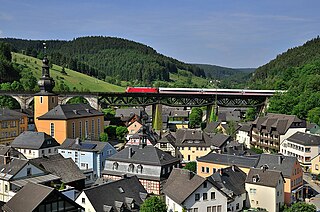
Ludwigsstadt is a town in the district of Kronach, in the Upper Franconian region of Bavaria, Germany.

The Dampfbahn Fränkische Schweiz e. V. or DFS is a German museum railway based in Ebermannstadt in Franconian Switzerland, part of northern Bavaria, Germany.

The Swabian Rezat is a 33.3-kilometre-long river in southern Germany (Bavaria). It is the southern, right source river of the Rednitz. It rises in the Franconian Jura hills, near Weißenburg in Bayern. It flows generally north through the towns Weißenburg in Bayern, Ellingen and Pleinfeld. Together with the Franconian Rezat, it forms the Rednitz in Georgensgmünd.

Bavarian cuisine is a style of cooking from Bavaria, Germany.
Upper German is a family of High German languages spoken primarily in the southern German-speaking area.
Lauer is a river of Bavaria, Germany. It flows into the Franconian Saale in Niederlauer.

Schmale Sinn is a river of Bavaria and Hesse, Germany. It is a right tributary of the Sinn near Zeitlofs. Via the Franconian Saale it discharges into the Main.

The Franconian Rake is the name given to the coat of arms of the region of Franconia in Germany. It is described heraldically as per fess dancetty of three points argent and gules. The points represent a stylised heraldic rake.


