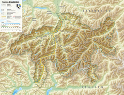
The Engadin or Engadine is a long high Alpine valley region in the eastern Swiss Alps in the canton of Graubünden in southeasternmost Switzerland with about 25,000 inhabitants. It follows the route of the Inn from its headwaters at Maloja Pass in the southwest running roughly northeast until the Inn flows into Austria, little less than one hundred kilometers downstream. The En/Inn subsequently flows at Passau into the Danube, making it the only Swiss river to drain into the Black Sea. The Engadine is protected by high mountain ranges on all sides and is famous for its sunny climate, beautiful landscapes and outdoor activities.

The Julier Pass is a mountain pass in Switzerland, in the Albula Alps. It connects the Engadin valley with central Graubünden, the nearest inhabited localities on its approaches being Silvaplana and Bivio. At its summit, the pass crosses the watershed / drainage divide between the basins of the rivers Rhine and Danube. The Julier Pass lies between Piz Lagrev and Piz Julier. A few metres south of the summit is the small lake Lej da las Culuonnas.

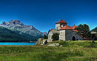
Lake Sils is a lake in the Upper Engadine valley, Grisons, Switzerland. It takes its name from the village of Sils im Engadin.
Lake Silvaplana is a lake in the Upper-Engadine valley of Grisons, Switzerland. It takes its name from the village of Silvaplana. The lake is also connected to the nearby Lej da Champfèr. Together with its larger neighbour, Lake Sils, it is among the largest lakes of the Grisons. Lake Silvaplana is overlooked by several mountains over 3,000 metres, notably Piz Corvatsch, Piz Julier and Piz Surlej. The lake's drainage basin culminates at Piz Corvatsch and comprises several glaciers, the largest being the Vadret dal Tremoggia.

Lake St. Moritz is a lake at St. Moritz, Switzerland. With a surface of 0.78 km2, it is smaller than the main lakes of the Upper Engadin valley.
Lej da la Tscheppa is a lake above Sils Maria, in the Engadine valley of the Grisons, Switzerland. Its surface area is 7.96 ha at an elevation of 2616 m. It used to be fed by water from the Crasta-Tscheppa Glacier.

Lej da Vadret is a lake below Roseg Glacier in the Grisons, Switzerland.
Hahnensee is a lake above St. Moritz in the Grisons, Switzerland at 2153 m above sealevel.

Muottas Muragl is a location on the southern slopes of the Blais da Muottas, a summit at the western end of the range descending from Piz Vadret, in the Swiss canton of Graubünden. It overlooks the Engadin, between the towns of Samedan, St. Moritz and Pontresina. The mountain is within the municipality of Samedan.
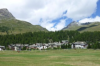
Champfèr is a village in the Upper Engadin valley of the canton of Graubünden, Switzerland. The Western part of the village belongs to the municipality of Silvaplana and part of the village belongs to the municipality of St. Moritz. The two halves of the town are separated by the creek Ova da Suvretta.

Lej Nair is a small lake on Bernina Pass in the canton of Grisons, Switzerland. It is located near the summit of the pass, between Lago Bianco and Lej Pitschen. While Lago Bianco drains to the Adriatic Sea, Lej Nair and Lej Pitschen are part of the basin of the Inn River draining into the Black Sea.

Lej Nair is a lake above Silvaplana in the Engadin valley, Grisons, Switzerland.

Lej da Gravatscha is an artificial lake next to the Inn River near Bever in the Upper Engadin, Grisons, Switzerland.

The Bernina railway line is a single-track 1,000 mmmetre gauge railway line forming part of the Rhaetian Railway (RhB). It links the spa resort of St. Moritz, in the canton of Graubünden, Switzerland, with the town of Tirano, in the Province of Sondrio, Italy, via the Bernina Pass. Reaching a height of 2,253 metres (7,392 ft) above sea level, it is the highest railway crossing in Europe and the third-highest railway in Switzerland. It also ranks as the highest adhesion railway of the continent, and—with inclines of up to 7%—as one of the steepest adhesion railways in the world. The elevation difference on the section between the Bernina Pass and Tirano is 1,824 m (5,984 ft), allowing passengers to view glaciers along the line.
The Nair are a group of Indian Hindu castes.

Punt Muragl Staz railway station is a railway station in the municipality of Celerina/Schlarigna, in the Swiss canton of Graubünden. It is located on the Bernina line of the Rhaetian Railway.
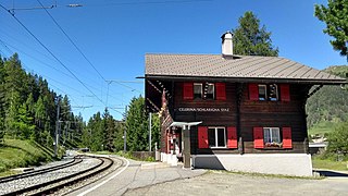
Celerina Staz railway station is a railway station in the municipality of Celerina, in the Swiss canton of Graubünden. It is located on the Bernina line of the Rhaetian Railway.

The Val Roseg is a valley of the Swiss Alps, located on the north side of the Bernina Range in the canton of Graubünden (Engadin). The valley is drained by the Ova da Roseg, a tributary of the Flaz, at Pontresina. Most of the valley is part of an exclave of the municipality of Samedan. Only the bottom of Val Roseg lies in the municipality of Pontresina.