Related Research Articles

Dangriga, formerly known as Stann Creek Town, is a town in southern Belize, located on the Caribbean coast at the mouth of the North Stann Creek River. It is the capital of Belize's Stann Creek District. Dangriga is served by the Dangriga Airport. Commonly known as the "culture capital of Belize" due to its influence on punta music and other forms of Garifuna culture, Dangriga is the largest settlement in southern Belize.

Stann Creek District is a district in the south east region of Belize. According to the 2010 census, the district had a population of 32,166 people. Its capital is the town of Dangriga, formerly known as "Stann Creek Town." Stann comes from "stanns," or safe havens used by colonialists coming from the "old world" to the "new world."

Toledo District is the southernmost and least populated district in Belize. Punta Gorda is the District capital. According to the Human Development Index (HDI), it is the second most developed region in the country. The district has a diverse topography which features rainforests, extensive cave networks, coastal lowland plains, and offshore cays. Toledo is home to a wide range of cultures such as Mopan, Kekchi Maya, Creole, Garifuna, East Indians, Mennonites, Mestizos, and descendants of US Confederate settlers.

Orange Walk District is a district in the northwest of the nation of Belize, with its district capital in Orange Walk Town.
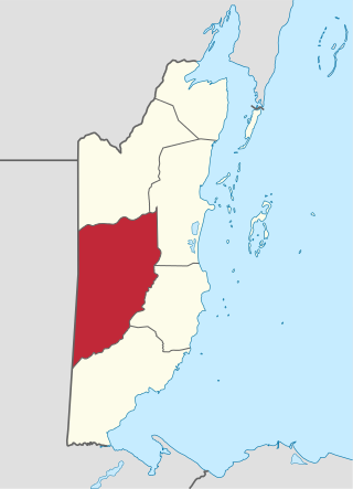
Cayo District is a district located in the west part of Belize. It is the most extensive, second-most populous and third-most densely populated of the six districts of Belize. The district's capital is the town of San Ignacio.

Hattieville is a village in the Belize District of the nation of Belize. It is located at 17N 88W, at an elevation of 196 feet above mean sea level, and has a population of about 1,300 people. Hattieville was established as a refugee camp after Hurricane Hattie made many people homeless in Belize City when it hit in 1961, but it became a permanent town.
Roaring Creek is a small village in the Cayo District of Belize, just north-west of Belmopan. Its name is derived from the creek waterfalls which flow into the Belize River next to the Guanacaste Park area.

Indian Church is a small remote village in the Orange Walk District of Belize. It is located on the west bank of New River, neighbouring the town of San Carlos to its south, and the Maya ruins of Lamanai to its north. According to the 2010 census, Indian Church has a population of 267 people in 66 households. The village is named for the historic Spanish churches recovered among the ancient Maya ruins. The residents lived among the ruins until 1991 when the Government of Belize established the 2-square-mile (5.2 km2) Lamanai Archaeological Reserve maintained by Belize's Institute of Archaeology.

Millbrook is a village in Kendall County, Illinois, United States. It was incorporated on November 5, 2002, and had a population of 335 at the 2010 census.
Gardenia is a village in Belize District, Belize located about 20 miles (32 km) north of Belize City.
Crooked Tree is a settlement located in the nation of Belize. It is a mainland village located in the Belize District.
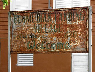
Bermudian Landing is a village in the nation of Belize, located near Scotland Halfmoon in Belize District. The name comes from the Bermuda grass planted by the early loggers to feed their oxen, who were used to drag the mahogany to the landing.
Double Head Cabbage is a village in Belize located in Belize District.
La Democracia is a populated settlement located in the nation of Belize. It is a mainland village that is located in Belize District.

Mahogany Heights is a village in the Belize District of the central-east coastal region of Belize. Though the area was originally inhabited by Mayans this village was established in the region of Belize that was first settled by Europeans. It is one of 192 municipalities administered at the village level in the country for census taking purposes. The village had several stores and a population of 1,063 in 2010. This represents roughly 1.2 % of the district's total population. No census record was taken for the village in 2000. Mahogany Heights was named for the Honduras Mahogany tree which was cut down as a chief export of Belize during the colonial period.
St. Ann's is a village in the Belize District of the central-east coastal region of Belize. Though the area was originally inhabited by Mayans this village was established in the region of Belize that was first settled by Europeans. It is one of 192 municipalities administrated at the village level in the country for census taking purposes. The village had a population of 97 in 2010. This represents roughly 0.1% of the district's total population. No census record was taken for the village in 2020.
Buena Vista is a village in the Cayo District of central interior Belize. It is situated along the Mopan River near the border with Guatemala. The village is in an agricultural region with the most frequent crops being citrus and banana. It is one of 192 municipalities administered at the village level in the country for census taking purposes. The village had a population of 599 in 2010. This represents roughly 0.9% of the district's total population. This was a 95.8% increase from 306 people recorded in the 2000 census.
Georgeville is a village in the Cayo District of central interior Belize. The village is in an agricultural region with the most frequent crops being citrus and banana. It is one of 192 municipalities administered at the village level in the country for census taking purposes. The village had a population of 922 in 2010. This represents roughly 1.4 % of the district's total population. This was a 60.9% increase from 573 people recorded in the 2000 census.

Unitedville is a village in the Cayo District of central interior Belize. The village is in an agricultural region with the most frequent crops being citrus and banana. It is one of 192 municipalities administered at the village level in the country for census taking purposes.
Yalbac is a village in the Cayo District of central interior Belize. The village is in an agricultural region with the most frequent crops being citrus and banana. It is one of 192 municipalities administered at the village level in the country for census taking purposes. The village had a population of 131 in 2010. This represents roughly 0.2 % of the district's total population. This was a 133.9% increase from 56 people recorded in the 2000 census. Yalbac is known to harbor significant examples of Maya architecture, and temple structures in the vicinity have been studied in the past.
References
17°36′36″N88°35′54″W / 17.61000°N 88.59833°W
| | This article about the geography of Belize is a stub. You can help Wikipedia by expanding it. |