Clay County is a county in the U.S. state of Nebraska. As of the 2010 United States Census, the population was 6,542. Its county seat is Clay Center. The county was formed in 1855, and was organized in 1871. It was named for Henry Clay, a member of the United States Senate from Kentucky, and later United States Secretary of State.

The Arctic Archipelago, also known as the Canadian Arctic Archipelago, groups together all islands lying to the north of the Canadian continental mainland excluding Greenland.
Square kilometre or square kilometer, symbol km2, is a multiple of the square metre, the SI unit of area or surface area.

Sanborn County is a county in the U.S. state of South Dakota. As of the 2010 United States Census, the population was 2,355. Its county seat and largest city is Woonsocket. The county was created by the Dakota Territorial legislature on May 1, 1883 with land partitioned from Miner County. It was fully organized by July 18, 1883.

Brown County is a county in the U.S. state of South Dakota. As of the 2010 United States Census, the population was 36,531, making it the fourth-most populous county in South Dakota. Its county seat is Aberdeen. The county is named for Alfred Brown, of Hutchinson County, South Dakota, a Dakota Territory legislator in 1879.

Nelson County is a county in the U.S. state of North Dakota. As of the 2010 United States Census, the population was 3,126. Its county seat is Lakota.

Foster County is a county in the U.S. state of North Dakota. As of the 2010 United States Census, the population was 3,343. Its county seat is Carrington.

Eddy County is a county in the U.S. state of North Dakota. As of the 2010 United States Census, the population was 2,385. Its county seat is New Rockford.

Yellowstone County is the most populous county in the U.S. state of Montana. As of the 2010 United States Census, the population was 147,972, and a 2018 estimate put the population at 160,137. Its county seat is Billings. Yellowstone County is named for the Yellowstone River which roughly bisects the county, flowing southwest to northeast. The river in turn was named after the yellow Sandstone cliffs in what is now Yellowstone County.

Teton County is a county in the U.S. state of Montana. As of the 2010 United States Census, the population was 6,073. Its county seat is Choteau. The county was founded in 1893.

Mineral County is a county located in the U.S. state of Montana. As of the 2010 United States Census, the population was 4,223. Its county seat is Superior.

Judith Basin County is a county in the U.S. state of Montana. As of the 2010 United States Census, the population was 2,072. Its county seat is the town of Stanford.

Fergus County is a county in the U.S. state of Montana. As of the 2010 United States Census, the population was 11,586. Its county seat is Lewistown. The county was founded in 1885 and named for James Fergus, a Montana politician who was instrumental in creating the county..

Beech Bottom is a village in Brooke County, West Virginia, along the Ohio River. It is part of the Weirton–Steubenville, WV-OH Metropolitan Statistical Area. The population was 523 at the 2010 census.

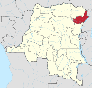
Bunia is a city in the Ituri Province of the Democratic Republic of the Congo (DRC) and the headquarters of Ituri Interim Administration. It was part of the Orientale Province until that province's dissolution.

The 2015 North Indian Ocean cyclone season was a below-average tropical cyclone season which featured the highest number of deaths since the 2010 season. Despite inactivity in the Bay of Bengal caused by the ongoing El Niño, the season produced an above-average number of tropical cyclones in the Arabian Sea. The first storm of the season, Ashobaa, formed on 7 June, while the final storm of the season, Megh, ultimately dissipated on 10 November.
The Koda River, locally called Khor Koda, is a seasonal tributary of the White Nile in the state of Jubek, South Sudan.
The Koda is a river in the Djugu Territory, Ituri province, Democratic Republic of the Congo. The name is also spelled Kodda or Kodha.
Kpandroma, also spelled Kpandruma or Kwandruma, is a town in the Ituri Province, Democratic Republic of the Congo. It is located at about 2050 m above sea level, on the Lendu Plateau, 17 km northwest of Lake Albert and 30 km southwest of the frontier with Uganda. Kpandroma is crossed by the RS436 road; it is about 3300 km from Kinshasa by road, 123 from the province's capital Bunia, 70 km from Drodro, and 40 km from Mahagi, the two nearest larger towns in the province.