Leonrodplatz

Last updated
Leonrodplatz (seen from the corner of Dachauer Strasse and Schwere-Reiter-Strasse) Leonrodplatz Muenchen Apr 2017.jpg
Leonrodplatz (seen from the corner of Dachauer Straße and Schwere-Reiter-Straße)

Leonrodplatz is a square in the Munich district of Neuhausen. It was named in 1927 after the former Bavarian Minister of Justice Leopold von Leonrod. [1]

Contents

Description

Leonrodplatz is located at the intersection of Dachauer Straße with Leonrodstraße and Schwere-Reiter-Straße or Dom-Pedro-Straße. The Olympiapark adjoins to the north-east.

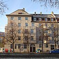
To the west, Leonrodplatz is closed around the beginning of Dom-Pedro-Straße and is lined by historically listed buildings from the beginning of the 20th century. To the north, Leonrodplatz will border on the 39,000 square metre, seven-storey building of the Strafjustizzentrum München (Criminal Justice Centre), which has been under construction there since 2016 on a major construction site in which the Free State of Bavaria is investing 300 million EUR [2] and is scheduled to be occupied by 2021. [3] 
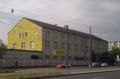
To the east, the Pathos Transport Theater has been located since 1982, as well as the Schwere-Reiter-Theater since 1993 and the Theater Werk München on Leonrodplatz since 2011, with the Munich Center of Community Arts (MUCCA) next door. [4] In the future, the Kreativquartier Schwabing will be created here, according to the Süddeutsche Zeitung "the liveliest and most versatile artist biotope" of Munich. [5] In the south are post-war buildings with retail shops, which were the location for the filming of the Tatort Die Wahrheit in May 2016. [6]

The tram lines from Hohenzollernplatz to Rotkreuzplatz and from Stiglmaierplatz to Westfriedhof and on to Moosach cross at Leonrodplatz.

In March 2017, the Neuhausen-Nymphenburg district committee decided to use a design competition to convert Leonrodplatz into a district centre. [7] The planned construction of a mosque for 800 praying people with a 20-metre high dome and 30-metre high minaret on Leonrodplatz, will not be realized, Imam Benjamin Idriz and the Munich Forum for Islam (MFI) had stood behind it. [8]

History

Map section from 1922 with the Maximilian-II-Kaserne and todays Leonrodplatz at the upper edge of the picture. Maximilian II-Kaserne (Grundriss um 1922).jpg
Map section from 1922 with the Maximilian-II-Kaserne and todays Leonrodplatz at the upper edge of the picture.

The area around todays Leonrodplatz was completely undeveloped until the middle of the 19th century. Later, the barracks quarter of Munich developed around Leonrodplatz. As of 1877, South of Leonrodplatz was the Maximilian-II-Kaserne as the largest barracks ever built in Munich, [9] which was destroyed in the Second World War. In 1890 the Eisenbahnkaserne were built north of todays Leonrodplatz, on whose territory the new Criminal Justice Center is now being built. During the construction of the justice centre, a 1,200 square meter underground structure was discovered, which stretched over a length of 80 meters and a width of 15 meters at a depth of up to five meters and was filled with scrap iron after 1945 when the Americans took up quarters. [2] East of Leonrodplatz, since the end of the 19th century, was the artillery workshops, further east the airship barracks (Luitpoldkaserne) were built in 1896 south of todays Schwere-Reiter-Straße and in 1935 the barracks kasern Oberwiesenfeld were added. In 1926, the barrel and Jutierhalle (Jute processing) were built at this corner, the area at the corner of Schwere-Reiter-Straße, Leonrodplatz and Dachauer Straße was used by the Stadtwerke München (public utilities), among others. As the successor of the police driving school, the volunteer fire brigade used a considerable part of the premises from 1995 to May 2016. From 2000 to 2003, the Munich Kammerspiele played in the Jutierhalle on Leonrodplatz. [10]

In 1883, the first Munich steam tram ran from todays Stiglmaierplatz to Nymphenburg, which at the time was located on the outskirts of the city. [11] However, since the trains frightened the horses on Nymphenburger Straße due to the noise, the line was moved to less busy parallel streets. [12] On 25 July 1909, the new tram connection from Stiglmaierplatz to Leonrodplatz was used for the first time. In 1928 the tram lines from Hohenzollernplatz to Rotkreuzplatz followed, and in 1930 the line from Stiglmaierplatz to Moosach station was extended.

For the 1972 Summer Olympics, a car bridge had been built over Leonrodplatz along Dachauer Straße, which was demolished again in the early 1990s. [13]

Related Research Articles

Maillingerstraße

The Maillingerstraße is a street in the Munich districts Maxvorstadt and Neuhausen. In the north–south direction, it connects Nymphenburger Straße with Marsstraße. It has been named after the Bavarian general and Minister of War Joseph Maximilian von Maillinger since 1886. Today Maillingerstraße is a minimal traffic secondary road.

Trams in Munich Tram system in the city of Munich, Germany

The Munich tramway is the tramway network for the city of Munich in Germany. Today it is operated by the municipally owned Münchner Verkehrsgesellschaft and is known officially and colloquially as the Tram. Previous operators have included Société Anonyme des Tramways de Munich, the Münchner Trambahn-Aktiengesellschaft, the Städtische Straßenbahnen and the Straßenbahn München.

Neuhausen-Nymphenburg

Neuhausen and Nymphenburg are boroughs of Munich, the capital of the German state of Bavaria. They had been merged into the borough 09 - Neuhausen-Nymphenburg in 1992. For further information on the Munich boroughs, see: Boroughs of Munich.

Maxvorstadt Borough of Munich

Maxvorstadt is a central borough of Munich, Bavaria, Germany and forms the Stadtbezirk (borough) 3 Maxvorstadt. Since 1992, this borough comprises the former boroughs 5, 6 and 7.

Dachauer Straße

The Dachauer Straße is the longest street in Munich with a length of 11.2 km and it received its name since it is the connecting road to Dachau Palace. In the north of Munich, it is part of the Bundesstraße 304.

Schleißheimer Straße (Munich)

Schleißheimer Straße is the second longest street in Munich after Dachauer Straße with a length of 8.14 km. It starts in the city centre at Stiglmaierplatz, leads through five districts and ends at Goldschmiedplatz. It takes its name from the northern suburb of Oberschleißheim, where it originally ended.

Moosach (Munich)

Moosach[ˈmoːsax] is the 10th northwestern district of Munich, Bavaria, Germany. It is sectioned in the urban districts Hartmannshofen, Pressestadt and Borstei

Stiglmaierplatz Public square in Munich, Germany

Stiglmaierplatz is a square in the Munich district of Maxvorstadt. It was named in 1845 after the artist Johann Baptist Stiglmaier and was previously the Kronprinzenplatz and since 1826 it was known as the Ludwigplatz.

Am Riesenfeld

Am Riesenfeld is the westernmost of the three subdistricts of the Munich city district 11 Milbertshofen-Am Hart.

Hohenzollernstraße is a two-kilometer-long street in Munich's Schwabing district.

Donnersbergerstraße

The Donnersbergerstraße is a street in the Munich district Neuhausen, in the city district of Neuhausen-Nymphenburg. It connects the Rotkreuzplatz with the Arnulfstraße in the north-south direction. It is named after the Privy Councilor and Supreme Chancellor of the Bavarian elector Maximilian I, Joachim Freiherr von Donnersberg (1561–1650), who came from the Munich patrician family, Donnersberger.

Lothstraße is a roughly 1.3 kilometer long street in Munich. It runs through the St. Benno district and forms the boundary between the municipality of Maxvorstadt, which lies southeast of the street, and the districts of Neuhausen and Schwabing-West, which are located northwest.

Schwere-Reiter-Straße

The Schwere-Reiter-Straße is a 1.2 km long street in Munich's Schwabing-West district in the Oberwiesenfeld area. It leads from Leonrodplatz to the Hohenzollernstraße on the corner of Winzererstraße, where it branches off to the north of the Ackermannstraße.

Hanauer Straße

Hanauer Straße in Munich is an arterial road about one and a half kilometers long extending from south to north in the Moosach district. It was named after the Hesse city of Hanau.

Arnulfstraße

The Arnulfstraße is a 3.8 km long urban street in Munich. It leads from the Bahnhofplatz in the Ludwigsvorstadt through the Maxvorstadt west to Romanplatz in Neuhausen. Over the Hackerbrücke, there is a connection to the Landsberger Straße, which runs parallel to the south of the railway tracks. Until 1983, the tram line 3 drove through the Arnulfstraße. It was initially diverted in the course of the Munich S-Bahn construction and then shut down. In 1996, the tram service was reopened on the Arnulfstraße with the line number 17.

Martiusstraße

The Martiusstraße in Munich Schwabing leads from Leopoldstraße to Kißkaltplatz. It was named after naturalist Carl Friedrich Philipp von Martius. He was director of the Alter Botanischer Garten in Munich and member of the Bavarian Academy of Sciences and Humanities.

Landshuter Allee

The Landshuter Allee is an avenue in Munich and through most of its course it is part of the Mittlerer Ring, the Bundesstraße 2 R. It joins Donnersbergerbrücke at Arnulfstraße in the Neuhausen district and runs from Dachauer Straße west of the Olympiapark to Moosacher Straße west of the Olympic village in the Moosach district. The B 2R leaves the intersection-free avenue at the Landshuter Allee and continues on the Georg-Brauchle-Ring. The Landshuter Allee now functions as the B 304 and connects the Mittlerer Ring with the northern tangent of the Outer Ring, which is only partially complete. The large width of the Landshuter Allee of 54 metres between the houses is striking. It crosses the Nymphenburg-Biedersteiner Kanal.

Petuelring

The Petuelring is an approximately 2.2 km long road in the north of Munich and part of the Mittlerer Ring. It runs between Georg-Brauchle-Ring and Schenkendorfstraße.

Kurfürstenplatz Square in Munich, Germany

Kurfürstenplatz is a square in the Munich district of Schwabing and is located about two and a half kilometres north of the city centre. It is the intersection of several streets and tram lines and was built in 1915 and named after the Elector Maximilian II. Emanuel, born in Munich in 1662.

References

  1. Dollinger, Hans (1997). Die Münchner Straßennamen. 3. Auflage (in German). Munich: Ludwig Verlag. p. 175. ISBN   3-517-01986-0.
  2. 1 2 "Gift-Funde verzögern Justiz-Neubau am Leonrodplatz" (in German). Tageszeitung. 23 May 2016. Retrieved 23 April 2020.
  3. Christian Rost (25 November 2015). "Wo in München künftig Recht gesprochen wird" (in German). Süddeutsche Zeitung. Retrieved 28 April 2020.
  4. "Kreativquartier" (in German). Institut für Angewandte Kulturelle Bildung. Retrieved 28 April 2020.
  5. "Ein Biotop für Künstler" (in German). Süddeutsche Zeitung. 11 January 2016. Retrieved 28 April 2020.
  6. Jonas Erlenkämper (23 October 2016). "Münchner "Tatort" ist ein Höhepunkt von Batic und Leitmayr" (in German). WAZ Funke Medien. Retrieved 28 April 2020.
  7. "Leonrodplatz: Aus der Kreuzung soll ein Platz werden" (in German). Tageszeitung. 7 March 2017. Retrieved 5 May 2020.
  8. Nina Bovensiepen (28 June 2016). "Pläne für Islamzentrum in München gescheitert" (in German). Süddeutsche Zeitung. Retrieved 5 May 2020.
  9. "KulturGeschichtsPfad Neuhausen-Nymphenburg" (PDF) (in German). Landeshauptstadt München. Retrieved 7 May 2020.
  10. "Kreativquartier" (in German). münchen.de. Retrieved 7 May 2020.
  11. "Die Geschichte Münchens". tschilli.ch (in German). Archived from the original on 4 November 2004. Retrieved 11 May 2020.
  12. Schattenhofer, Michael. 100 Jahre Münchner Straßenbahn (in German). Munich: Münchner Stadtarchiv. p. 28.
  13. "Schönheitskur für den Leonrodplatz" (in German). Süddeutsche Zeitung. 17 March 2017. Retrieved 11 May 2020.

Coordinates: 48°09′34″N11°32′48″E / 48.1595°N 11.5468°E / 48.1595; 11.5468