
The City Circle is a mostly-underground railway line located in the Sydney central business district and Haymarket, in New South Wales, Australia, that forms the core of Sydney's passenger rail network. The lines are owned by the Transport Asset Holding Entity, a State government agency, and operated under Transport for NSW's Sydney Trains brand. Despite its name, the City Circle is of a horseshoe shape, with trains operating in a U-shaped pattern. The constituent stations of the Circle are (clockwise): Central, Town Hall, Wynyard, Circular Quay, St James, Museum and back to Central.

The Australian state of New South Wales has an extensive network of railways, which were integral to the growth and development of the state. The vast majority of railway lines were government built and operated, but there were also several private railways, some of which operate to this day.
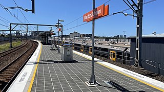
Macdonaldtown railway station is a partially heritage-listed railway station located on the Main Suburban line, serving the Sydney suburb of Eveleigh. It is served by Sydney Trains' T2 Leppington & Inner West Line and occasional T3 Liverpool & Inner West Line services.

Oak Flats railway station is a railway station located in Oak Flats, New South Wales, Australia, on the South Coast railway line. The station serves NSW TrainLink trains travelling south to Kiama and north to Wollongong and Sydney. Together with the Dunmore and later Shellharbour Junction stations, Oak Flats has long served as the rail connection for the coastal suburbs of the City of Shellharbour.

Dungog railway station is located on the North Coast line in New South Wales, Australia. It serves the town of Dungog opening on 14 August 1911. Originally built with only one face, in 1944 the platform was converted to an island platform and the present station building constructed.

Yerrinbool is one of the Northern Villages of the Southern Highlands of New South Wales, Australia, in the Wingecarribee Shire, and is accessible from the Hume Highway and is about a 12 km (7.5 mi) drive from nearby Mittagong. It is 7 km (4.3 mi) to Hill Top as the crow flies, accessible by foot via a fire trail. It is on the western edge of the Upper Nepean Nature Reserve, a vast area of forest, lakes and dams between Yerrinbool and the coastal communities around Wollongong. Yerrinbool was previously officially known as the Town of Yerrinbool. It is located on the historic Old Hume Highway.

Billinudgel is a town in the Northern Rivers region of New South Wales, Australia, and is part of Byron Shire. The Murwillumbah railway line once passed through the town and a railway station was opened there in 1894.

The Main Southern Railway is a major railway in New South Wales, Australia. It runs from Sydney to Albury, near the Victorian border. The line passes through the Southern Highlands, Southern Tablelands, South West Slopes and Riverina regions.

Tumblong is a village community in the central east part of the Riverina and situated about 18 kilometres (11 mi) south east from Mundarlo and 25 kilometres (16 mi) northwest of Adelong. It was known as Adelong Crossing or Adelong Crossing Place until 1913. At the 2011 census, Tumblong and the surrounding area had a population of 338.

Wongarbon is a village approximately 18 kilometres east of Dubbo on the Mitchell Highway between Dubbo and Wellington, New South Wales, Australia. The name is also applied to the surrounding area for postal and statistical purposes. At the 2016 census, Wongarbon had a population of 766.
The Mungindi railway line is a railway line in northern New South Wales, Australia. It branches from the Main North line at Werris Creek station and heads north-west through the towns of Gunnedah and Narrabri before reaching Moree which for many years was the railhead before the extension to Mungindi was constructed. The line is currently truncated to Weemelah between Moree and Mungindi. Passenger trains still operate to Moree, and goods trains operate to Camurra. As of 1 September 2009, services have been suspended between Camurra and Weemelah. The line between Werris Creek and Moree is also known as the North-West line.

Albert is a town in the Central West region of New South Wales, Australia. The town is in the Lachlan Shire local government area, 481 kilometres (299 mi) west north west of the state capital, Sydney.

Leadville is a town in New South Wales, Australia. The town is located in the Warrumbungle Shire local government area, 376 kilometres (234 mi) north west of the state capital, Sydney. At the 2016 census, Leadville and the surrounding area had a population of 169.
Environa is a suburb and locality of Queanbeyan, located in the Queanbeyan–Palerang Regional Council, in New South Wales, Australia, west of Jerrabomberra Creek and nearby the New South Wales and Australian Capital Territory border. The development was described as a planned community, but it did not come to fruition. However, Environa has since been allocated as part of the South Jerrabomerra development of Queanbeyan for proposed development, including the proposed developments of Tralee and Poplars.
Goondah railway station was a railway station in Goondah, New South Wales, Australia on the Main South Line 340 kilometres (210 mi) from Sydney.
Trewilga is a bounded rural locality in Parkes Shire, within the Central West region of New South Wales, Australia. There was once a village and railway station of the same name. Prior to 1913, the village was known as Mingelo.

Jerrawa is a locality in the Upper Lachlan Shire, New South Wales, Australia. It lies on the north side of the Hume Highway about 30 km to the east of Yass and was served by Jerrawa railway station on the Main Southern line between Sydney and Melbourne between 1876 and 1975. At the 2016 census, it had a population of 73.

Colinton is a locality in the Snowy Monaro Region, New South Wales, Australia. At the 2021 census, it had a population of 115. There was once a village and railway station of the same name.

The Cadia Mine railway line is a closed and dismantled railway line in New South Wales, Australia. The 18.5 km long branch line started where it branched from the Main Western Railway line at Spring Hill and ended at Cadia. Its main role was to carry iron ore from the quarry at Cadia and for much of its life was privately operated.