
Rhineland-Palatinate is a western state of Germany. It covers 19,846 km2 (7,663 sq mi) and has about 4.05 million residents. It is the ninth largest and sixth most populous of the sixteen states. Mainz is the capital and largest city. Other cities are Ludwigshafen am Rhein, Koblenz, Trier, Kaiserslautern and Worms. It is bordered by North Rhine-Westphalia, Saarland, Baden-Württemberg and Hesse and by the countries France, Luxembourg and Belgium.

The Palatinate is a historical region of Germany (Deutschland). In the Middle Ages it was known as the Rhenish Palatinate (Rheinpfalz) and Lower Palatinate (Unterpfalz), which strictly speaking designated only the western part of the Electorate of the Palatinate, as opposed to the Upper Palatinate (Oberpfalz). It occupies roughly the southernmost quarter of the German federal state of Rhineland-Palatinate (Rheinland-Pfalz), covering an area of 2,105 square miles (5,450 km2) with about 1.4 million inhabitants. Its residents are known as Palatines (Pfälzer).
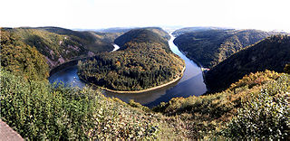
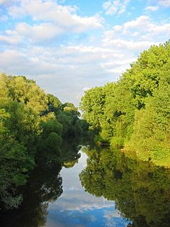
The Saar is a river in northeastern France and western Germany, and a right tributary of the Moselle. It rises in the Vosges mountains on the border of Alsace and Lorraine and flows northwards into the Moselle near Trier. It has two headstreams, that both start near Mont Donon, the highest peak of the northern Vosges. After 246 kilometres (153 mi) the Saar flows into the Moselle at Konz (Rhineland-Palatinate) between Trier and the Luxembourg border. It has a catchment area of 7,431 square kilometres (2,869 sq mi).

The Nahe is a river in Rhineland-Palatinate and Saarland, Germany, a left tributary to the Rhine. It has also given name to the wine region Nahe situated around it.

The Rhine Province, also known as Rhenish Prussia (Rheinpreußen) or synonymous with the Rhineland (Rheinland), was the westernmost province of the Kingdom of Prussia and the Free State of Prussia, within the German Reich, from 1822 to 1946. It was created from the provinces of the Lower Rhine and Jülich-Cleves-Berg. Its capital was Koblenz and in 1939 it had 8 million inhabitants. The Province of Hohenzollern was militarily associated with the Oberpräsident of the Rhine Province.

Moselle Franconian is a West Central German language, part of the Central Franconian language area, that includes Luxembourgish. It is spoken in the southern Rhineland and along the course of the Moselle, in the Siegerland of North Rhine-Westphalia, throughout western Rhineland-Palatinate and Saarland, Luxembourg, the south of the German-speaking Community of Belgium and in the neighboring French département of Moselle. The Transylvanian Saxon dialect spoken in the Transylvania region of Romania is derived from this dialect as a result of the emigration of numerous "Transylvanian Saxons" between 1100 and 1300, primarily from areas in which the Moselle Franconian dialect was then spoken.
The Wied is a river in Rhineland-Palatinate, Germany, and a right tributary of the Rhine.

The Glan is a river in southwestern Germany, right tributary of the Nahe. It is approximately 68 km long. It rises in the Saarland, northwest of Homburg. It flows generally north, through Rhineland-Palatinate, and empties into the Nahe near Odernheim am Glan, at Staudernheim, across the Nahe from Bad Sobernheim. Other towns along the Glan are Altenglan, Glan-Münchweiler, Lauterecken and Meisenheim.

Kirrberg is a district of Homburg, situated in the eastern part of the Saarpfalz (Saar-Palatinate) district and the Saarland bordering state Rhineland-Palatinate. Until End 1973 was Kirrberg an independent municipality in the former Homburg district. Homburg (5 km), Zweibrücken (7 km), Saarbrücken and Kaiserslautern are the closest towns. As of 1 August 2021, 2,607 inhabitants live in Kirrberg.

The Prüm is a river in Rhineland-Palatinate, Germany, left tributary of the Sauer.
The Schwarzbach is a river in southwestern Germany, left tributary of the Blies. Its source is in the Palatinate Forest, near Trippstadt. It flows through the states Rhineland-Palatinate and Saarland. Towns along its course are Waldfischbach-Burgalben, Contwig and Zweibrücken. After 50 km (31 mi), it flows into the Blies in Homburg-Einöd.
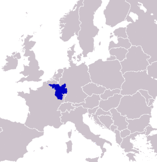
SaarLorLux or Saar-Lor-Lux, a portmanteau of Saarland, Lorraine and Luxembourg, is a euroregion of five regional authorities located in four European states. The term has also been applied to cooperations of several of these authorities or of their subdivisions, administrations, organisations, clubs and people. Member regions represent different political structures: the sovereign state of Luxembourg; Belgium's Walloon region, comprising the French and German speaking parts of Belgium; Lorraine, a region of France; the French départements Moselle and Meurthe-et-Moselle; and the German federated states of Saarland and Rhineland-Palatinate.
The Prims is a 91 km long river in western Germany, right tributary of the Saar. It rises in the Hunsrück mountains, near the village Malborn. It flows generally south through the towns Nonnweiler, Wadern and Schmelz. It flows into the Saar in Dillingen.
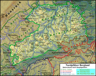
The North Palatine Uplands, sometimes shortened to Palatine Uplands, is a low mountain range and landscape unit in the German state of Rhineland-Palatinate and belongs mainly to the Palatinate region. It is part of the Saar-Nahe Uplands.

The Principality of Lichtenberg on the Nahe River was an exclave of the Duchy of Saxe-Coburg-Saalfeld from 1816 to 1826 and the Duchy of Saxe-Coburg and Gotha from 1826 to 1834, when it was sold to the Kingdom of Prussia. Today its territories lie in two States of Germany – the District of St. Wendel in Saarland and the District of Birkenfeld in Rhineland-Palatinate.

The Greater Region of Luxembourg, or simply Greater Region, is a geopolitical region within Europe, created to promote economic, cultural, touristic and social development and cooperation. It occupies an area of 65,401 square kilometres (25,251 sq mi) with Luxembourg at its center and including adjacent regions of Belgium, Germany and France.

The Wadrill is a river of Saarland and Rhineland-Palatinate, Germany. It is a right tributary of the Prims, which it joins south of Wadern.
The Saar-Nahe Hills or Saar-Nahe Uplands is a major natural region in the German states of Rhineland-Palatinate and the Saarland. The region of hills and mountains covers an area of 4,185 km² running from Saarbrücken, Kaiserslautern and the Palatine Forest in the south to the Hunsrück in the northeast. It contains the catchment area of the Nahe as far as Bad Kreuznach as well as small sections of the Middle Saar in the west.
The Dollberge are a small mountain range in the northern Saarland and the adjoining part of the state of Rhineland-Palatinate in Germany. They form a southeastern element of the Schwarzwälder Hochwald, a region in the Hunsrück mountains, and are up to 707.4 m above sea level (NN).
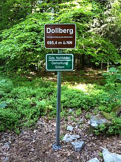
The Dollberg is a mountain in the Dollberge range in central Germany and the highest point in the state of Saarland. It is 695.4 m above sea level (NHN) and lies within the Schwarzwälder Hochwald on the boundary between the counties of Trier-Saarburg (Rhineland-Palatinate) and St. Wendel (Saarland).
